FortressWeissenburg

Fortress Wülzburg

Fortress Wülzburg

The Fortress can be visited
School


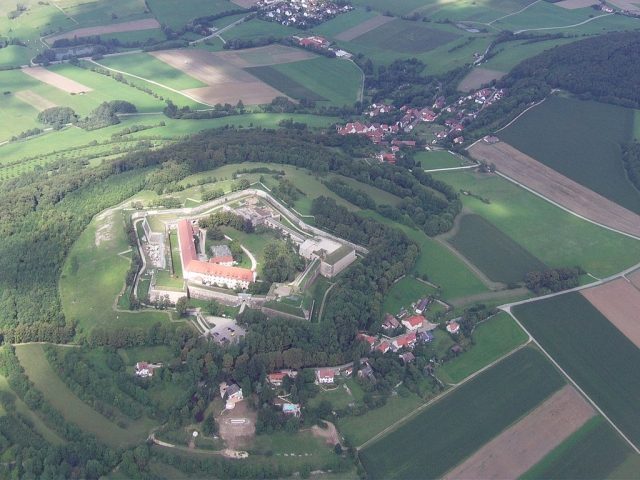
The Wülzburg – in the area of the large district town of Weißenburg in Bavaria (district of Weißenburg-Gunzenhausen) in the Franconian Jura – is a historic fortress built between 1588 and approximately 1610. It was originally a Benedictine monastery, converted into a fortress in 1588. Today, the Wülzburg and the residential houses south of the fortress form a district of Weißenburg.

The Wülzburg is located in the Altmühltal Nature Park, about 2.5 km east-southeast of the center of Weißenburg's core town. It stands on the Wülzburger Berg, which belongs to the Weißenburger Alb and, at 620 m above sea level, is the highest peak of the southern Franconian Jura after the Laubbichel (635.7 m) to the east-northeast. The platform of its northeast bastion (called Roßmühle) lies at an altitude of 643.8 m.

Monastery+

Legends

In Alfred Kriegelstein's book "Sagen Legenden Geschichten aus Mittelfranken" from 1983 (ISBN 3-7689-0203-X), on page 233 f., the following legend about the founding of the monastery on the Wülzburg can be found:

Pippin the Short and the Wülzburg

The Roman Empire had long since collapsed, the Roman buildings, houses, and castella had fallen into disrepair or completely disappeared. The Franks inhabited the land, over which their princes now ruled. One of the most powerful was King Pippin the Short. He once came hunting in the wooded heights near the Roman fort at Weißenburg. Hunting fever had seized him. He was chasing fleeting game, separated from his retinue, and could not find his way back. Pippin wandered in the wilderness. Night fell. He sought a resting place and finally settled at the foot of an old oak tree. But he found no sleep. He thought back to the times when Germans and Romans had fought here in these forests and suddenly saw a white figure: a young, beautiful Germanic girl. It floated like a misty image. The king followed it like a sleepwalker. And the figure led him to a height. From here, he could survey the entire surrounding land in the light of the full moon. There he met his retinue, to whom the white figure had shown him the way. Out of joy and gratitude for this rescue, he ordered a church to be built on this height. The church was followed by a monastery, and the monastery later became a fortress that can still be seen today: the Wülzburg near Weißenburg.

The original Wülzburg monastery was visited several times by Charlemagne, at least according to the legend of the Karlsgraben.

Nothing more is known about the church and monastery before the 11th century. As a Benedictine monastery with the patronage of Peter and Paul, it is said to have been founded in the first half of the 11th century as a Salian foundation and belonged to the Diocese of Eichstätt.

The Wülzburg monastery is mentioned in the Vita of Saint Otto, Bishop of Bamberg: Around 1060/62, Otto was born of Swabian nobility and probably received his education in the Benedictine monastery on the Wülzburg in Weißenburg, Middle Franconia.

Eichstätt Bishop Konrad (1153–1171) was previously abbot of the Wülzburg monastery. In 1254, Pope Innocent IV allowed the abbot of Wülzburg to grant absolution to monks who had violated the vows of poverty and obedience and had even been excommunicated for attacks on the two preceding abbots. In 1395, two murders occurred in the monastery, which shook the surrounding area.

Towards the end of the 14th century, the monastery came into the hands of the Burgraves of Nuremberg (since 1415 Margraves of Brandenburg). This had devastating consequences in the 15th and 16th centuries, as it was repeatedly drawn into armed conflicts.

In the second great War of the Cities, Weißenburg citizens plundered and set fire to the Wülzburg monastery in 1451. At the beginning of the 16th century, the monastery was dissolved and thereafter served as a farm. From 1523 to 1536, there was still a collegiate chapter, which counted eight canons and four vicars. The dissolution then took place in 1537. In 1588, the monastery buildings were razed.

Abbots of the Monastery

  • around 1090 Heinrich
  • before 1146 Johannes
  • 1146–1152 Eberhard
  • 1152–1153 Konrad von Morsbach
  • 1153–1160 Berthold
  • 1160–1163 Effridus
  • 1163–1180 Isembertus
  • 1180–1187 Konrad
  • 1187–1194 Heinrich
  • 1194–1209 Rigenhardus
  • 1209–1219 Konrad
  • 1219–1238 Peregrinus
  • 1238–1247 Burhard
  • 1247–1256 Otto von Schwabsberg
  • 1256–1269 Ulrich von Muhr
  • 1274–1301 Berthold von Münster
  • 1302–1318 Werner
  • 1323–1333 Konrad Lenzenauer
  • 1335–1348 Ulrich von Hausen
  • 1349–1357 Heinrich der Feiste
  • 1357–1378 Konrad von Morsbach
  • ????–1381 Ulrich
  • 1381–1391 Wilhelm (der) Putz
  • 1391–1395 Heinrich der Sachs
  • 1395–1419 Ulrich (Widenmann)
  • 1419–1449 Wilhelm (his tombstone is still found today in the castle chapel)
  • 1449–1475 Johannes Castner
  • 1475–1495 Wilhelm Warnhofer
  • 1495–1510 Michel Helmbauer
  • 1510–1524 Veit von Gebsattel

1523 Conversion of the monastery into a collegiate chapter

  • 1524–1528 Gumbrecht von Brandenburg
  • 1529–1531 Christoph Beck
  • 1531–1536 Friedrich von Brandenburg

1536 Secularization

Fortress+

Alongside the Citadel of Jülich (1549ff) and the Citadel of Spandau (1560ff), the Wülzburg is one of the three closely related fortresses that have been preserved in the German-speaking world. They uniquely illustrate the typical Renaissance military architecture of the era.

In place of the Benedictine Abbey of St. Peter and Paul at Wülzburg, the Wülzburg fortress was begun in 1588. The patron was Margrave Georg Friedrich the Elder of Brandenburg-Ansbach and -Kulmbach (1539–1603). Construction was initially led by court architect Blasius Berwart, then the Brandenburg court architect Rochus Graf zu Lynar drew up new plans, the realization of which until around 1605 was in the hands of the architects Caspar Schwabe, Blasius Berwart the Younger, Albrecht von Haberland, Thomas Martinatus, and Gideon Bacher. Completion took place around 1610.

During the Thirty Years' War, the fortress was surrendered without a fight to the imperial troops under Tilly in 1631 and only returned to Brandenburg-Ansbach in 1649. Despite long Swedish blockades, the fortress remained unconquered. In 1639, a fire destroyed parts of the complex. From the 17th to the 19th century, the fortress also served as a state prison (see also the report on the Great Franconian Thieves' and Robbers' Gang). In 1791, the Margraviate of Ansbach and with it the Wülzburg fell to Prussia; in 1806, the Wülzburg came to the Kingdom of Bavaria. The Bavarian Ministry of War then carried out extensive renovations to make the fortress usable for the army again. In 1867, after the stay of the Infantry Regiment, the fortress status of the Wülzburg was lifted, and the building, with the exception of the southern castle wing, was sold to the city of Weißenburg in 1882, in whose possession the fortress remains to this day.

During the First World War, the Wülzburg was used as a prisoner-of-war camp. In 1918, the later French President Charles de Gaulle was imprisoned here until the end of the war in November 1918 (though interrupted by an escape attempt). A commemorative plaque to him is located inside the gatehouse. On June 20, 1929, the first school country home in Bavaria was opened at the Wülzburg.

During the Second World War, the Wülzburg was an internment camp, which is why the so-called Russian Cemetery is located at the Fallgarten, where, in addition to the graves of 40 Russian merchant sailors, the grave of the Prague composer Erwin Schulhoff can also be found.

After the Second World War, the Wülzburg was a mass refugee camp, and from 1952 to 1968, the state-owned south wing housed a district old people's home.

In 1968, the Wülzburg was designated a nationally significant monument as an excellently preserved Renaissance fortress. Since 1969, the fortress has been undergoing renovation. Today, the castle building houses, among other things, a vocational school for special educational support, with a focus on learning, which is run by the Rummelsberger Anstalten.

Architectural Description+

The 73,000 square meter fortress is an almost regular pentagonal bastion system in the Neo-Italian style. Its pentagonal shape allows for the defense of the fortress without blind spots. The five bastions are named, counter-clockwise from the entrance in the south: Jungfrau (Maiden), Krebs (Crab), Roßmühle (Horse Mill), Kaltes Eck (Cold Corner), and Hauptwache (Main Guard). The entire complex is built from the local limestone, and the dry moat, up to 10 m deep and 23 m wide, is partly carved out of the rock and partly created by embanking the slope. Construction of the moat began on June 25, 1588. Of the extensive courtyard buildings from the 17th–19th centuries, only the two-winged castle in the south and west remains, as well as an economic building from 1814 south of the center of the courtyard. A relay station of the Deutsche Bundesbahn is also located in the inner courtyard. An approximately 50 m high radio mast at the relay station was dismantled in 2007.

Remarkable are the large casemates in the bastions, some of which reach over 6 m in height. The highlight is the domed hall of the former Roßmühle with a diameter of more than 14 m.

The Deep Well in the west wing originally served as the water supply. At 143.2 m (after excavation), it is one of the deepest fortress wells in Germany. It was built around 1600 and has a diameter of 2.5 m. Between 1823 and 1831, the Kingdom of Bavaria built six rainwater cisterns (according to plans by the Bavarian engineer captain Franz von Hörmann); five of them in the rampart walls, the largest cistern centrally in the inner courtyard. This, called Ludwigszisterne (after King Ludwig I of Bavaria), was the largest of its kind in the entire kingdom and remains a top product of engineering to this day. The Ludwigszisterne holds 1.3 million liters, which can be drawn from four pump and draw wells each.

The Covered Way around the fortress with its weapon emplacements from the 18th century is very well preserved at the Wülzburg, an exceptional case among German fortresses, where these outermost defensive structures were often the first to be razed. At the Wülzburg, the Covered Way consists of a dry stone wall, partly taller than a man, which was formerly reinforced with palisades. In recent years, the city of Weißenburg has begun to renovate this Covered Way and repair collapses. In addition, some of the trees on the glacis have been felled, so that the mountain fortress can once again be seen from afar – and the structure is also better experienced and understood on the 1 km long circular walk.

After the portal, built as an ornamental gate with the coat of arms of Margrave Georg Friedrich and his wife Sophie depicted on it, follows a representative riding ramp from the 16th century, which leads up around a large angular pillar to the attic.

On the gun platform of the Jungfrau Bastion, there is a water tower (around 1900) for the water supply of the fortress and neighboring hamlets. Three of the five bastions have square watchtowers, which allow a view of the glacis. At the Hauptwache Bastion, there is the hexagonal main guardhouse with an onion dome.

Castle Chapel St. Nicholas+

The small Protestant church in the southern castle wing was built around 1605. The church's furnishings date from 1738 and 1864. With just under 20 members, the church has the smallest parish in Bavaria.

Future Prospects+

Until approximately the year 2000, costs for maintenance and restoration work on the fortress, which is almost entirely owned by the city of Weißenburg, were borne by the Free State of Bavaria, the district of Middle Franconia, and from the current budget of the city of Weißenburg. Several million Deutschmarks or Euros were invested annually in securing the existing structure. After the Free State and the district reduced or ceased their subsidies, the city of Weißenburg no longer considers itself able to maintain the building fabric in its previous form. It can only raise around 350,000 Euros per year. At the city's New Year's reception in 2006, the then Lord Mayor Reinhard Schwirzer quoted the opinion of an engineering firm that, due to a lack of funds, it would be necessary in the future to consider deliberately not preserving parts of the fortress and allowing them to collapse. This caused considerable sensation and led to the initiation of an extensive renovation campaign for several million Euros in the coming years.

Houses on Wülzburger Berg+

South of the fortress, just before its entrance, lies the hamlet of Wülzburg with some residential houses and its own cemetery. West below the fortress lies the Weißenburg district of Häuser am Wülzburger Berg, also known as Siedlung Wülzburg. The settlement is located at altitudes between 445 and 500 m in the wedge between Federal Highway 13 and the eastern bypass. Near the settlement are the Aumühle, the Birkhof, the Glaserhaus, and the Sommerkeller. South of these are the ponds Erlweiher, the Alte Badeweiher, and the Schafweiher. From Weißenburg, the houses on the Wülzburger Hang are only separated by the bypass road (a shared section of Federal Highways 2 and 13).

Take Mobile History with you

You are reading this text for free. Premium adds what matters on the road: descriptions read aloud, sites found through your camera, whole regions taken offline.

  • Every description, including the ~17,700 Premium sites
  • Audio guide: have descriptions read to you on location
  • AR finder: see sites through your camera, with distance and bearing
  • Unlimited saved sites

14 days free, then from €2.99 a month. Cancel anytime.

Source: Wikipedia · Licence: CC BY-SA 4.0 · Image: http://commons.wikimedia.org/wiki/File:Luftbild_Wuelzburg.JPG?uselang=de

This description draws on the facts documented in the linked Wikipedia article; Wikipedia content is licensed under CC BY-SA 4.0. Wording and editing: Mobile History.

Location: 49.0255, 11.0048