FortressBuoux

Fort Buoux

Fort Buoux

The remains of the fortress can be visited

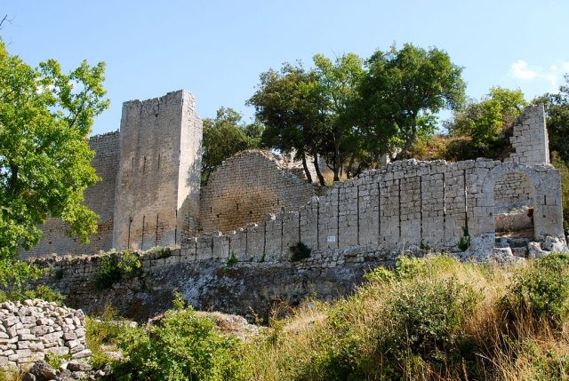
Fort Buoux is a ruined fortress in the territory of the southern French commune of Buoux. It is located on the northern flank of the Grand Luberon mountain range, occupying a molasses base surrounded by rocky peaks.

Since 1986, the Fort has been classified as a protected historical monument (Monument historique).

A fortification already existed at the site of the Fort in prehistoric times. Later, a Celto-Ligurian oppidum and a Roman castrum were built, from which the only passable route over the Luberon was controlled. The medieval castle was built in the 13th century and was long considered impregnable. The Huguenots used the castle as a retreat in the 16th century until Louis XIV had it demolished around 1660.

Description+

Access

The Fort is located on a difficult-to-access rock formation, approximately 500 m long and 30 to 100 m wide. The rock consists of sedimentary layers, deposited over 20 million years by marine sediments.

The path leading to the Fort follows an old ancient road that passes under a huge rock overhang (Abri). The rocks were provided with various hollows in the Neolithic period, which served as storage pits and burial sites. The path carved into the rock leads to a first bastion and a round-arched entrance gate guarded by it.

Fortress grounds and medieval village

The fortress grounds were protected by a fortification wall, which formed the first line of defense of the castrum. On the grounds are a former vaulted water reservoir with a capacity of 60,000 liters and a defensive ditch, which was intended to deter potential attackers.

Parallel to the terrain stand the protective walls of a medieval village, consisting of storehouses, scattered wall sections, and cave dwellings. A remarkable 13th-century house features a round-arched portal made of wedge stones. In front of the fortress, on a rocky, formerly covered square, one finds thirteen silos carved into the stone and traces of a wine press.

The Fortress

The fortress was built in the 13th century as a spur castle. It is particularly well adapted to the topographical conditions and was provided with three fortification walls, each protected by ditches. The first wall, equipped with a raised gate, has closely spaced arrow slits. The second protective wall is very high and was reinforced with a square tower. The third wall finally occupies the space on the two vertical cliffs.

The keep, originally built on three levels, overlooks an abyss up to 80 m deep. The sally port is located at the bottom of the grain silos and leads to a secret staircase, whose role is still unclear. It could have been an important part of the defense system or had a cultural function in early history.

Take Mobile History with you

You are reading this text for free. Premium adds what matters on the road: descriptions read aloud, sites found through your camera, whole regions taken offline.

  • Every description, including the ~17,700 Premium sites
  • Audio guide: have descriptions read to you on location
  • AR finder: see sites through your camera, with distance and bearing
  • Unlimited saved sites

14 days free, then from €2.99 a month. Cancel anytime.

Source: Wikipedia · Licence: CC BY-SA 4.0 · Image: http://de.wikipedia.org/wiki/Datei:Vue_g%C3%A9n%C3%A9rale_du_fort_de_Buoux.jpg

This description draws on the facts documented in the linked Wikipedia article; Wikipedia content is licensed under CC BY-SA 4.0. Wording and editing: Mobile History.

Location: 43.8181, 5.3799