FortressReutte

Fort Claudia

Fort Claudia

The remains of the fortress can be visited


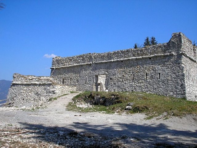
Fort Claudia ("Hochschanz") in the municipality of Reutte was built in the 17th century as part of the barrier fortress system around Ehrenberg Castle in Tyrol's Außerfern region. The remains of the small fortress were secured and partially reconstructed after the turn of the millennium.

The Falkenberg, opposite Ehrenberg Castle, had already proven to be a weak point in the Ehrenberg fortification system in the 16th century. The princely fortress builder Elias Gumpp therefore began planning a fort around 1639, which was intended to make bypassing the castle more difficult. The new building was named after the sovereign Claudia von Medici - the widow of Archduke Leopold V.

During the War of the Spanish Succession, the Bavarian Elector was nevertheless able to capture the castle (1703). However, the Tyroleans recaptured it shortly afterwards. To do this, cannons were pulled up to the still unfortified Schlosskopf behind the fortress and the castle was shelled until it was ready for assault. These events proved the necessity of another fortification on the Schlosskopf, which towers about 150 meters above the medieval core castle. From 1726 to 1741, a huge fortress was therefore built on the mountain (Schlosskopf Fortress).

Already in 1782, the Tyrolean state fortresses, with the exception of Kufstein, were abandoned and partially demolished. However, the fort remained inhabited until the 19th century. Subsequently, the decay of the complex began, which, together with the fortress, remained almost unnoticed by research until the turn of the millennium. Many locals were also largely unaware of the fortifications around the castle.

As part of the development of the Ostallgäu-Außerfern castle region, initial preservation measures began around the year 2000, which have largely been completed in the area of the fort. To restore the historical sightlines, larger areas of mountain forest had to be cleared.

Description+

The fort is located on an almost flat plateau on the mountainside east of the federal highway. Opposite, the castle thrones at almost the same height on its mountain saddle, which the Schlosskopf with the fortress overtops. In the mountain forest, the outworks and redoubts around the core work can still be partially well traced. Some of these fortifications seem to have been built before the 17th century. In addition, ramparts run to the hermitage on the mountain saddle. The cannons were certainly here in front of the fort, whose embrasures only allowed the use of muskets.

The heavily ruined remains of the core work were conserved and partially rebuilt after 2000. The base area is square, with side lengths of about 20 m. To the east, two acute-angled bastions project. Another small bastion protected the entrance gate on the west side. The bastions are only about half as high as the rest of the masonry and are accessible from the interior. The masonry is broken at regular intervals by narrow musket loopholes, which were trapezoidally widened on the inside and finished with round arches. On the outside, a bulging cordon cornice runs around the upper part of the complex. The local limestone of the area served as building material.

Take Mobile History with you

You are reading this text for free. Premium adds what matters on the road: descriptions read aloud, sites found through your camera, whole regions taken offline.

  • Every description, including the ~17,700 Premium sites
  • Audio guide: have descriptions read to you on location
  • AR finder: see sites through your camera, with distance and bearing
  • Unlimited saved sites

14 days free, then from €2.99 a month. Cancel anytime.

Source: Wikipedia · Licence: CC BY-SA 4.0 · Image: http://commons.wikimedia.org/wiki/File:Fort_Claudia_5.jpg

This description draws on the facts documented in the linked Wikipedia article; Wikipedia content is licensed under CC BY-SA 4.0. Wording and editing: Mobile History.

Location: 47.4619, 10.7228