FortressSaint Peter

Fort Saumarez

Fort Saumarez

The Fort can be visited

Fort Saumarez is a Martello tower in Saint Peter, Guernsey, on a headland that forms the northern tip of L'Erée and extends to the Lihou causeway. It was constructed in 1804 on the site of an existing battery after the onset of the Napoleonic Wars, and during the tenure (1803-1813) of Lieutenant Governor General Sir John Doyle. Doyle named the tower for the Guernsey native and renowned Royal Navy Captain, Sir James Saumarez, who at the time was commander of British naval forces in the Channel Islands. To simplify matters, Doyle had a local builder named Gray construct the tower, and two others, see below, under the rubric of "fieldworks", thereby bypassing the Ordnance Corps.

The Fort Saumarez tower, like the other two Guernsey Martello towers, Fort Grey and Fort Hommet, was intended as a keep for the battery in which it was placed. The Guernsey Martellos are smaller than the British towers, with the Fort Saumarez and Fort Hommet towers being smaller than the Fort Grey tower. Each mounted a 24-pounder carronade on the roof to protect the battery. Fort Saumarez and Fort Hommet also have exterior staircases up to the second floor.

Doyle was responsible for substantial fortification efforts elsewhere in Guernsey, including the construction of the two other Martello towers. Because of its location, Fort Saumarez also served as one of six to ten optical telegraph stations that ringed the coast to give warning of approaching vessels.

In 1852, the battery at Fort Saumarez received 32-pounder guns and 8" shell guns in place of some of its 24-pounder guns.

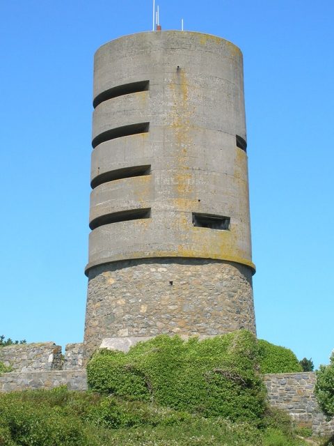
During World War II and the German occupation of the Channel Islands, the Germans recognized the enduring utility of the site and built a four-storey concrete observation tower on top of the fort. At some point the battery around the Fort Saumarez tower was demolished. Fort Saumarez is now privately owned and not publicly accessible.

Take Mobile History with you

You are reading this text for free. Premium adds what matters on the road: descriptions read aloud, sites found through your camera, whole regions taken offline.

  • Every description, including the ~17,700 Premium sites
  • Audio guide: have descriptions read to you on location
  • AR finder: see sites through your camera, with distance and bearing
  • Unlimited saved sites

14 days free, then from €2.99 a month. Cancel anytime.

Source: Wikipedia · Licence: CC BY-SA 4.0 · Image: http://en.wikipedia.org/wiki/File:Fort_Saumarez_close_2.JPG

This description draws on the facts documented in the linked Wikipedia article; Wikipedia content is licensed under CC BY-SA 4.0. Wording and editing: Mobile History.

Location: 49.4576, -2.6558