The Castle can be visited
Frankenburg Castle

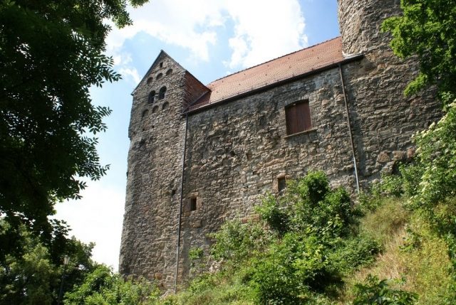
The Frankenburg is a high medieval fortification on a tiny mountain spur above the town of Bad Frankenhausen on the southern edge of the Kyffhäuser in the Thuringian Kyffhäuser district. The castle site is a protected monument, whose grounds are used for tourism.
The castle site is located at the northeastern corner of the medieval town fortifications and only about 400 meters from the center of the former salt extraction facilities (Nappenplatz). Above the castle, on the adjacent Schlachtberg, the decisive battle of the German Peasants' War between the united Thuringian peasant armies and the princely army took place in 1525.
Long before the town was granted city rights, which can be dated from 1219 with the first mention of Frankenhausen as an oppidum, an initial castle complex of the Counts of Rothenburg was built at this strategically important location in the immediate vicinity of the salt extraction site. It was referred to as Frankenhaus in 998 and must have been significant, as the current place name seems to be derived from it. The fortification was then referred to as the property of the Counts of Schwarzburg Haus in 1340, as Oberburg in 1381, and as Alte Burg in 1592. It only received its current name Hausmannsturm after 1550, when a kind of residence for the fire and town watchmen could be established in the militarily insignificant complex. Such accommodations were called Hausmannsturm in contemporary sources. As owners of the castle, the Counts of Schwarzburg often pledged this complex, which had become possible due to the second castle complex built in the lower town around 1380 at the site of the present castle.
Description+
The castle consists of a massive round tower with a diameter of nine meters and a wall thickness of up to three meters, as well as the tower-like residential building attached to the south, which offered little space with a base area of 12 by 17 meters. The existing complex was still surrounded by a ring wall and seamlessly connected to the town wall. It thus dates to its construction period after 1210. Documented evidence of a predecessor building has not yet been proven by structural findings. The castle site is located on a small hill, which was secured on three sides by a moat dug into the soft gypsum rock. The only access was via a ladder to an elevated gate. A later secret escape passage allowed the castle garrison to escape unnoticed. The part of the town immediately below the castle was called Alte Burg. The residence of the castle men and the location of the necessary economic buildings are to be assumed there.
Oldest depiction by Merian
The town view by Matthäus Merian from 1650 suggests that the old castle had been renovated. Its palas was provided with a stepped gable and a steep roof facing south, into which several dormers or bay windows were inserted. The depicted keep was a cylindrical building with an octagonal spire and six outer turrets. Six supports rising from these carry the upper spire with the tip and the crowning finial. The hour bell was placed between the two spires.
Depiction by Bleichrodt
Around 1800, a folder with town views of Frankenhausen was created by the artist family Bleichrodt. Among them are several detailed views of the Hausmannsturm, which allow further conclusions about the building's history. It is known from the town chronicle that the town, economically weakened by town fires, most recently in 1759, had to neglect maintenance work on the Hausmannsturm, which was also affected by storm and weather damage.
Miscellaneous+
As a landmark of the city, the Hausmannsturm was depicted in its current appearance on a special stamp in 1998 for the city's 1000th anniversary of Bad Frankenhausen.
Take Mobile History with you
You are reading this text for free. Premium adds what matters on the road: descriptions read aloud, sites found through your camera, whole regions taken offline.
- Every description, including the ~17,700 Premium sites
- Audio guide: have descriptions read to you on location
- AR finder: see sites through your camera, with distance and bearing
- Unlimited saved sites
14 days free, then from €2.99 a month. Cancel anytime.
Source: Wikipedia · Licence: CC BY-SA 4.0 · Image: Roland Neubert, Halle (Saale)
This description draws on the facts documented in the linked Wikipedia article; Wikipedia content is licensed under CC BY-SA 4.0. Wording and editing: Mobile History.
Location: 51.3608, 11.1043