Municipal offices
CastleWürzburg
Grafeneckart Castle
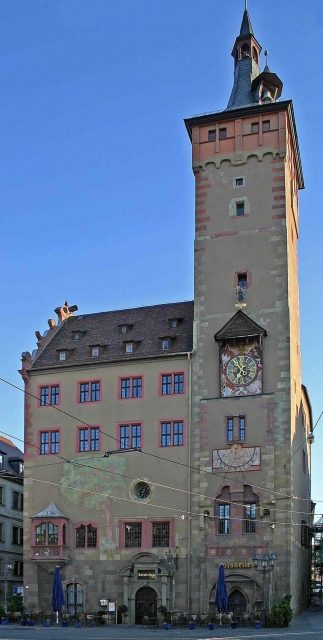
The Grafeneckart is the oldest part of Würzburg's City Hall. It is located in the old town near the Vierröhrenbrunnen (Four-Tube Fountain). The 55-meter-high Romanesque tower makes this historically significant monument, situated between Domstraße and the Old Main Bridge, recognizable from afar.
The building was first mentioned in 1180 as a medieval noble tower. The tower was named after the episcopal Schultheiß and Vice-Burgrave "Eggehardus," who resided here.
The originally Romanesque building complex was acquired by the city in 1316 and continuously expanded and heightened in the following centuries. Council meetings were moved from the "Hof zur Glocke" (later Haus zum Hirschen) to the Grafeneckart. In 1453, the tower was extended and equipped with the fire and storm bell. In 1508, another bell was added. The attached side wing is named "Grünbaum." Here is the old council hall (Wenzelsaal). Towering high above the old town's bourgeois houses, the building embodied the liberal self-understanding of the Würzburgers striving for autonomy and is a symbol of civic freedom.
During the bombing raids on March 16, 1945, the medieval core of the Grafeneckart was partially hit. While the vaults and facade remained intact, the extensions above the Wenzelsaal, carried out in the 16th century, were completely destroyed. As a result, the Wenzelsaal was also affected and renovated in 1950.
In 2003, there was an extensive interior restoration of the Wenzelsaal.
Building+
- The square in front of the building is named Beim Grafeneckart; the building has the designation "Beim Grafeneckart 1" and is part of the City Hall complex, therefore connected to Rückermainstraße 2.
- The two-story Wenzelsaal, a medieval secular hall, has a floor area of 9.50 by 12.30 meters and is divided into two naves of 6.70 meters (above a basement) and 4.70 meters width. It is one of the very few and well-preserved Romanesque rooms in Germany from this period that did not belong to a church. Around 1336, the hall was decorated with murals.
- The tower height is 55 meters.
- A remarkably beautiful sundial adorns the south facade of the tower, easily admired from the Vierröhrenbrunnen. The inscription admonishes modesty: "No human spirit can stop the course / Of sun, moon, and stars." However, it is also remarkable for its inaccuracy. Even after precise conversion of all accurately calculable seasonal and longitude deviations, it deviates, especially in the afternoon, by up to 40 minutes. Fortunately, this does not diminish its beauty in any way. Those who still value catching it displaying the true local time should visit it on a sunny morning in May.
- On the ground floor of the Grafeneckart, there is a memorial room commemorating the destruction of Würzburg. This was modernized in 2010/2011. However, the use of the term "terrorist attack" on the new information boards sparked controversial discussions.
Guided Tours+
From May 6 to October 26, 2013, free City Hall tours, lasting approximately one and a half hours, will again take place every Saturday. The meeting point is at 11 AM at the City Hall courtyard at Grafeneckart, opposite the Vierröhrenbrunnen. Among other things, the historic Grafeneckart Tower and the Council Hall with its monumental mural by Wolfgang Lenz will be visited. The Wenzelsaal, the oldest part of the City Hall, and the Coat of Arms Hall will also be on the program.
Take Mobile History with you
You are reading this text for free. Premium adds what matters on the road: descriptions read aloud, sites found through your camera, whole regions taken offline.
- Every description, including the ~17,700 Premium sites
- Audio guide: have descriptions read to you on location
- AR finder: see sites through your camera, with distance and bearing
- Unlimited saved sites
14 days free, then from €2.99 a month. Cancel anytime.
Source: Wikipedia · Licence: CC BY-SA 4.0 · Image: http://wuerzburgwiki.de/wiki/Datei:Wuerzburg_grafeneckart.jpg
This description draws on the facts documented in the linked Wikipedia article; Wikipedia content is licensed under CC BY-SA 4.0. Wording and editing: Mobile History.
Location: 49.7933, 9.9285