Educational Institution
ManorSchwedt (Oder) - Criewen
Criewen Manor
More pictures
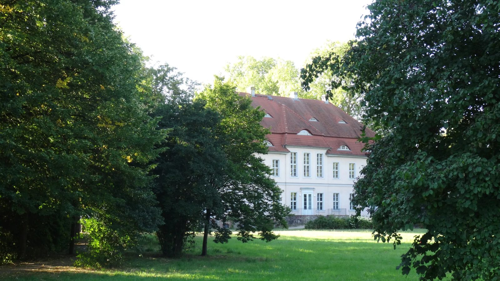
The Criewen estate is located in Criewen, a district of Schwedt/Oder in Brandenburg. The estate, consisting of a manor house, the farmyard, the estate park or Lenné Park with a gardener's house and tool shed, is a listed building.
History+
Already in the Middle Ages, four knight's seats existed here, but their exact locations are not known. Therefore, the history of the present estate can only be traced from the beginning of the 18th century. After the von Stegelitz family was dispossessed of the estate in 1707, it was given by King Frederick I to the ennobled valet, subsequently privy councillor and treasurer Daniel von Luck (1674–1739). His family combined the four estate shares and built a manor house in 1746. Since there were no descendants of the von Luck family beyond another generation, the estate was given to the Royal War Councillor Crüger in 1761. He passed the estate on to his daughter as a wedding gift. This was followed by the equally ennobled von Rebeur family, to whom a sandstone monument from 1792 once commemorated. In 1816, Otto von Arnim-Gerswalde acquired the estate, which became the ancestral seat of the new von Arnim-Criewen family branch. He transformed the estate with the entire village. Thus, the village, despite protests from the inhabitants, was relocated about 500 meters to the northeast, and the manor house was completely rebuilt from 1818 to 1823. The side wings were probably also added around this time. Furthermore, the farmyard, the nursery, and the park were created around this time. In 1877, Bernd von Arnim-Criewen became the lord of the manor. He redesigned the manor house around 1900. From 1910, the manor house was further rebuilt, among other things, the hip roof was replaced by a mansard roof. The property belonging to the entire complex included, before the Great Depression of 1929/1930, the Criewen manor (507 ha) and the Densen manor (392 ha), including 160 ha of forests. There was a medium-sized agricultural enterprise. Notable owners at that time were the politician Bernd von Arnim, then his son, Major Achim von Arnim, married to Annabel von Stoesser, both of whom took their own lives in Criewen after the end of the war in 1945. From 1945, the youngest scion of the von Arnim-Criewen family occupied two rooms in the castle, the rest was occupied by refugees. From 1954, a vocational school for agriculture with a boarding school was located here. After the reunification, the manor house was used as a rural school home. After the renovation from 1997 to 2002, the Brandenburgische Akademie Schloss Criewen used the manor house. Furthermore, nature conservation institutions are located in the house.
The Manor House+
The manor house is a three-wing complex. The central building consists of a two-story structure with a mansard roof, the single-story side wings were added later. The current main view towards the Old Oder is characterized by the three-axis entrance risalit with a portico with four columns. Above the columns is an altana with three balcony doors. In the triangular gable of the risalit is the coat of arms of the von Arnim-Criewen family. There are dormer windows in the mansard roof. The side facing the Oder has eleven axes, the side facing the park nine axes. The park side is also characterized by a central risalit. The interior furnishings essentially date from the last quarter of the 19th century and the beginning of the 20th century.
The Farmyard+
The farmyard is located east of the manor house. At the corner of Am Speicher / Bernd-von-Arnim-Straße is a granary, which was built after 1816 in the style of Prussian rural architecture. It is a two-story building on a square floor plan with a tent roof. The corners and central axes are emphasized by pilasters. Southwest of it is the former horse stable, a brick building with a high gabled roof. Today, the Haus Natura 2000 is located here. Immediately southwest of it is the coach house with a coachman's apartment. On the gabled roof is a roof turret for a possible servant's bell. Northwest of the granary stands the former cattle stable. The visitor center of the Lower Oder Valley National Park is located in this building. South of the corner Grüner Weg / Am Speicher and thus north of the manor house is the estate nursery with its buildings. The complex is now used as an ecological show and teaching garden. The nursery essentially consists of a tool shed, gardener's house, seed house, an ice cellar, and a water tower. The tool shed is designed like a chapel, it was built around 1822. Like the tool shed, the gardener's house was built of fieldstone. The water tower has an octagonal floor plan and was built of brick. The ice cellar is used to store ice blocks from the Oder to cool food in summer. It is a fieldstone building with walls about one meter thick. The seed house was only built in 1884. The nursery includes a pump house on the canal, which supplied the water tower with water. Inside is a still functional pump from 1920.
The Estate Park+
Around 1816, the village was relocated, which also marked the beginning of the planning of the estate park. However, a park probably already existed northwest of the manor house from 1770. From 1822, the estate park was designed. The plans came from Peter Joseph Lenné. The village church, an old village lime tree, and the remains of the baroque park were included in the park. Around 1850, the park was changed, and Lenné also provided the plans for that. From 1894, the Old Oder was dammed and the Hohensaaten-Friedrichsthal waterway was built, which changed the bank area. After 1945, the park was used by agricultural enterprises and allotments. A district heating pipeline was laid through the park. From 1965, the park was protected according to the Landeskulturgesetz of the GDR. Thus, from 1970, the park was maintained again, and from 1990, these maintenance works were intensified. The park encloses the manor house on three sides, the farmyard is in the northeast. In the west, the park is visually connected by orchards, in the east there are sightlines to the Hohensaaten-Friedrichsthal waterway. In the south are foothills of the forests towards the Oder valley, southwest a pond. Furthermore, there are some meadows in the park.
Take Mobile History with you
You are reading this text for free. Premium adds what matters on the road: descriptions read aloud, sites found through your camera, whole regions taken offline.
- Every description, including the ~17,700 Premium sites
- Audio guide: have descriptions read to you on location
- AR finder: see sites through your camera, with distance and bearing
- Unlimited saved sites
14 days free, then from €2.99 a month. Cancel anytime.
Source: Wikipedia · Licence: CC BY-SA 4.0 · Image: Foto: Jörg Heldt (Community)
This description is a machine translation of an excerpt from the linked Wikipedia article. The source text was written by its authors, the translation is by Mobile History; like the original it is licensed under CC BY-SA 4.0.
Location: 53.0103, 14.2210