ManorAachen - Laurensberg

Hochbrücker Mühle Manor
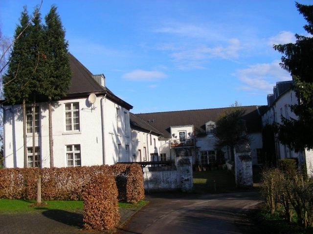
Hochbrücker Mühle Manor

To be privately owned

The Hochbrücker Mills were a double mill complex on the right and left banks of the Wurm stream. They consisted of the mill "Der Roßkamp" and the actual "Hochbrücker Mill". In 1923, the Wurm, which separated the two mills, was relocated and the old streambed filled in, so that now a path runs between the two buildings. During Aachen's great copper master era, they served for a time as copper mills. On November 9, 1771, according to an entry in the feudal register, the mill is mentioned as a hide and oil mill, and on February 9, 1778, as a grinding and oil mill. As a grinding mill, the mill was still operated even after the Wurm regulation, but now electrically. On March 31, 1519, Clais Rulant is found as the owner of the Hochbrücker Mills, which, at least after their division by Clais' sons, were both copper mills. In the 18th century, the Tilmann family appears as owners. On October 5, 1758, Privy Councillor von Collenbach acquired the mill at an auction from Leonard Savelsberg. The three-winged courtyard complex was built in its present form in the 18th and 19th centuries. The brick courtyard complex consists of the two-story east wing, the north wing, the former barn, and the two-story west wing with an attached stable section.

Changed ownership after Privy Councillor Collenbach probably led, through division, to the wall that longitudinally divides the entire complex, cutting the courtyard quite arbitrarily.
On the other side of the path are the buildings of a courtyard complex from the 18th to 19th centuries. The three-winged brick courtyard complex is whitewashed and has steep gabled roofs. The east wing consists of a two-story, L-shaped residential building with two by two axes and a gate passage. West of the gate passage stands a two-story utility building. The west wing consists of the former mill with outer walls of quarry stone. To the north, the former barn with a basket-arch gate passage bricked up on the courtyard side adjoins. The field side is enclosed by a wall with a gate entrance. Both courtyard complexes have been converted since 1980 due to the cessation of agricultural use.

Take Mobile History with you

You are reading this text for free. Premium adds what matters on the road: descriptions read aloud, sites found through your camera, whole regions taken offline.

  • Every description, including the ~17,700 Premium sites
  • Audio guide: have descriptions read to you on location
  • AR finder: see sites through your camera, with distance and bearing
  • Unlimited saved sites

14 days free, then from €2.99 a month. Cancel anytime.

Source: Wikipedia · Licence: CC BY-SA 4.0 · Image: http://www.wehrbauten.de/thread.php?threadid=845

This description draws on the facts documented in the linked Wikipedia article; Wikipedia content is licensed under CC BY-SA 4.0. Wording and editing: Mobile History.

Location: 50.8015, 6.1065