Uninhabited
Neparmitz Manor

The Neparmitz estate is a former large agricultural enterprise in Neparmitz, municipality of Poseritz, Vorpommern-Rügen district. The manor house, park, and the lord's burial site are listed as historical monuments.
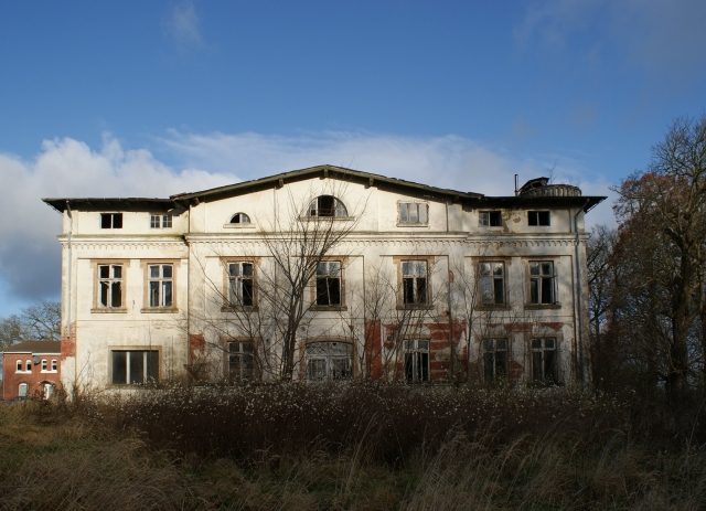
In 1856, Ehrenfried Gustav Holz (1807–1885) acquired the estate, which originated in the 17th century, and developed it into a large agricultural enterprise. By 1885, the complex with the manor house, four large stables, carriage house, park, and farmworker houses was completed. Around 1900, ownership passed into the hands of the Wahnschaffe family. They managed Neparmitz until their expropriation in 1945. With the land reform, the Neparmitz estate was transferred to the LPG "Freie Scholle". This later merged into the LPG "Völkerfreundschaft" in Poseritz. After the political change, agricultural operations in Neparmitz ceased. The former estate was taken over by TLG Treuhand Liegenschaftsgesellschaft mbH and sold to a private investor in 1998. The entire complex has been in decay ever since. The manor house, the park, and the burial site have been listed as historical monuments since 1993.
Buildings+
For the manor house, the Historicism style was chosen, in keeping with the taste of the time, with elements from Gothic and Roman-Byzantine architecture. It has a show facade facing south towards the park, with three window axes on each side of the garden portal. The main entrance is on the western narrow side, leading to a curved driveway and staircase. The low walls of the driveway are covered with granite slabs, and the endpoints are adorned with spheres. Above the entrance, a large rectangular area stands out, within which the surrounding ornamental frieze is missing, and modern windows from GDR-era production, unrelated to the architecture, have been installed. Until the 1960s, a representative altan was located here. The northern front of the manor house is partially obstructed by a connecting corridor to utility and ancillary buildings. An Art Nouveau window located in the stairwell area is severely restricted in its effect by the extensions. On the eastern narrow side of the building is a narrow stair tower. Inside the building, a shocking picture of decay and vandalism is evident, behind which the original furnishings are no longer recognizable. The floor ceilings have collapsed, the roof is open, and the stairwell was destroyed by arson. The masonry consists of red bricks, structured by horizontal stripes of yellow bricks. Due to the joints, originally colored red, and the carefully executed jointing, the appearance resembles the neighboring manor house of Grabow and some railway buildings from the same period on the island of Rügen.
Park and Burial Site+
South and east of the manor house lies a small, rural park whose horticultural design and structure are very difficult to discern due to severe overgrowth. The design featured well-placed, solitary park trees, including chestnut, oak, ash, plane tree, maple, and holly. On the eastern edge is a pond system and a ditch system that delineates the area from the surrounding arable land. In the southeastern corner of the park lies the burial site of the Holz and Wahnschaffe families, enclosed by a fieldstone wall. The last burial recorded is that of Ada Wahnschaffe, née von Schleussner († 1944). The graves are destroyed. Among the park trees, the plane tree, common ash, and holly are additionally designated as natural monuments due to their distinctive characteristics.
Farm Buildings+
Of the large cattle stables that were grouped around a courtyard 150 m long and 100 m wide to the west of the manor house, only one remains. At the western end of the courtyard, a gate system with brick pillars opens. On the eastern edge of the courtyard are the small animal stable and a carriage house with a clock and bell tower. All buildings are in decay.
Take Mobile History with you
You are reading this text for free. Premium adds what matters on the road: descriptions read aloud, sites found through your camera, whole regions taken offline.
- Every description, including the ~17,700 Premium sites
- Audio guide: have descriptions read to you on location
- AR finder: see sites through your camera, with distance and bearing
- Unlimited saved sites
14 days free, then from €2.99 a month. Cancel anytime.
Source: Wikipedia · Licence: CC BY-SA 4.0
This description draws on the facts documented in the linked Wikipedia article; Wikipedia content is licensed under CC BY-SA 4.0. Wording and editing: Mobile History.
Location: 54.2874, 13.3120