To be privately owned
Traar Manor

Haus Traar is a former knight's estate in Krefeld-Traar, An der Elfrather Mühle 241. It was the namesake for the formerly independent town, which is now a district of the North Rhine-Westphalian city of Krefeld. Built by nobles in the mid-13th century as a knight's estate, it soon came into the possession of the Teutonic Order for about 500 years. After secularization, the property was continuously used as an agricultural estate by all subsequent owners. After the cessation of agricultural use, all farm buildings were converted into residential units starting in 1992.
After the clearing and settlement of the area and the construction of the first farms in the 10th century, a moated castle Are and the Knights of Are (te Are = Traar) were first mentioned in a document dated June 11, 1255. The coat of arms of Are showed three eagles between a green horizontal bar on a silver shield. Shortly after its construction, the castle was gifted in 1274 by its builders Albert von Are (ter Are = Traar) and his wife Aleidis von Rode (Rode = Rath) to the Teutonic Order due to childlessness. Despite multiple challenges to the donation by relatives, they failed to regain possession. Only a final settlement documented in 1293 resolved the dispute. The property remained in the ownership of the Teutonic Order until secularization in 1802. Haus Traar was incorporated into the Bailiwick of Koblenz. Later, together with the Order house in Rheinberg, it formed the Commandery of Traar and Rheinberg. The coats of arms with the cross of the Teutonic Order at the entrance gate still commemorate its past as a knight's estate.
Due to two fires, in 1584 during the Truchsessian War and in 1641/42 by Hessian-Weimar troops, all buildings were destroyed. Reconstruction and further leasing to Johann Halfmann auf Arrh began in 1647. The manor house was rebuilt in 1664 and the chapel in 1669. In 1715, it temporarily served as the official residence of the Commanders in the manor house. The property had parliamentary rights but not jurisdiction or hunting rights.
After the left bank of the Rhine became French in 1801 with the Peace of Lunéville, the knight's estate passed into the possession of the French domain administration as part of the secularization; the tenant of Haus Traar redeemed the annual rent of one malter of rye payable to the Marienhospital in Bockum by a one-time payment of 450.75 Francs to the French state. After the final expropriation of the Teutonic Order by the French, in 1812 Carl Joseph Henoumont (born 1750 in Bissen/Luxembourg and from 1773 Professor of Law at the University of Düsseldorf) and his wife Maria Anna von Daniels bought the property for 20,000 Francs. A few years after the acquisition, the new lord of the manor was "treacherously" shot from outside through the window pane in the manor house and died of his wounds on June 12, 1816. His nephew of the same name became his heir († 1869). The so-called Gut Traar was leased to the Libbertz/Heggels family from 1816. The Henoumont family built the farm buildings in 1817, laid out the lime avenue including the bridge over the Kendel, and rebuilt the manor house to its current state in 1830. They donated the plot of land for the construction of the Traar parish church of St. Josef in 1834. From 1844, they also acquired possession of Haus Rath, which was within sight. Haus Traar then passed by purchase to Karl Anton Schmitz in 1857 and by inheritance in 1874 to his son-in-law Max Winkelmann, the then mayor of Lobberich, whose son Karl Winkelmann took it over in 1895. In 1928, the Krefeld manufacturer Oskar von Beckerath, a descendant of the banker and politician Hermann von Beckerath, acquired it from his widow Agnes, née Baumann. Oskar von Beckerath appointed the farmer Ludwig von Holtum as administrator, who achieved considerable breeding successes at Haus Traar. The owner von Beckerath regularly claimed high losses from the Haus Traar estate to the tax office, so that in 1939 he was accused of hobbyism rather than profit-making intent. In 1949, in an application for a reduction in the standard value, he stated as a reason for the poor agricultural yields that due to the Lower Rhine coal mining since 1928, the groundwater level had dropped by several meters. In 1950, Oskar von Beckerath offered the now listed property for sale and had it described in an exposé as an excellent operation with 200 acres of the best land and first-class buildings.
Peter Weber, a farmer in Bad Godesberg, bought the Haus Traar estate by purchase agreement dated March 6, 1951, with buildings and 49.8 hectares of land at a price of 290,000 DM plus living and dead inventory. The Weber family had previously been forced to vacate the "Plittersdorfer Aue" estate, leased from the majorat owner Robert von Carstanjen, at short notice due to the impending construction of the American HICOG new settlement, after Bonn became the federal capital in 1949. With the controversial compensation payments from the USA, Peter Weber was able to buy Haus Traar. The brothers Friedrich Peter and Helmut Weber took over the farm from their father in 1959. Significant changes arose in 1969 from the construction of today's federal highway 57 right through the fields belonging to Haus Traar. The Weber brothers pursued a lawsuit through several instances up to the Federal Court of Justice for a fair compensation arrangement, because formerly large fields were divided into small, only restrictively usable parcels by the highway construction. Due to the changed requirements of modern agriculture and the needs of the nearby big city (residential areas, highway construction, water protection zones, recreation areas), agricultural use was abandoned in 1990 after more than 750 years by the last active farmers, the brothers Friedrich Peter and Helmut Weber. Except for the manor house and the chapel, they sold all buildings and properties to the city of Krefeld in 1990. Subsequently, the farm buildings were converted into condominiums, and large parts of the former arable land were leased for golf course use. After two generations in the hands of the Weber family, the owners of the manor house, which is considered one of the oldest continuously inhabited houses in Krefeld, changed for the last time in 2009.
Description+
Entrance Gate
A portal designed in baroque forms from the second half of the 17th century leads into the inner courtyard. It consists of two brick, diagonally supported pilaster posts, each crowned by a lion as a shield-bearer with the coats of arms of the Teutonic Order on sandstone capitals. The pillars and walls are made of brick, the ornaments of sandstone. The heavily weathered sculptures were replaced by replicas in the late 1990s.
Manor House
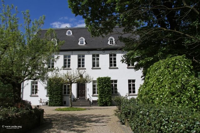
The manor house is a two-story building constructed of plastered brick, with seven axes (length 19.80, width 10.60 meters), a gabled roof over a wooden cornice, and a central door. The new building from 1664 had lateral curved stepped gables, a central gable over the west facade, and a slender octagonal turret at the northwest corner. The year of construction is evidenced by the inscription "ANNO 1664" formed by iron anchors on the main facade. The current appearance dates back to a renovation around 1830 (changes to the door, roof, dormers, removal of the turret, new interior staircase). During these construction measures, the wooden front door with transom and a stone frame with a keystone bearing a coat of arms was also installed. In 1993, the manor house was renovated by the Weber family in accordance with monument preservation standards, preserving the historical building fabric and furnishings, and converted for contemporary use. In particular, the installation of a second staircase made it possible to divide the approximately 450 m² of usable space into individual units. During the renovation, the oak windows could no longer be used after 160 years of life and were replaced by profiled wooden windows of the same dimensions. Noteworthy are the preserved hand-hewn 17th-century oak roof truss, the up to 50 cm wide oak floorboards, the interior staircase, and the doors from the early 19th-century renovation.
Halfmannshaus
On the site of a thatched half-timbered building, a two-story brick residential house was erected in 1760 (anchor pins), with four by three axes and a half-hipped roof. It was renovated in 1860 (keystone above the entrance) and served as the administrator's house, also called Halfmann. The name Halfmann derives from the condition that in earlier times, half of the harvest had to be given to the lord as rent. In addition, manual labor and services with draft animals also had to be provided.
Farm Buildings
The farm buildings with stables, forge, and barn were built of brick in 1817 and later. After the cessation of agricultural use in 1991, the property, including the arable land, was sold to the city of Krefeld. An investor converted the farm buildings into condominiums supported by monument protection. Due to the necessary installation of many windows, the construction of an underground car park, and the conversion of the paved courtyard area into small-scale garden use, the agricultural character has been lost. The wooden barn with a formerly impressive roof truss was also bricked up, fitted with windows, and converted into a multi-family residential building. In the mid-1990s, the Elfrather Mühle golf course was built on the arable land belonging to the estate, and a hotel complex, now operated by the Novotel chain, was built on the former orchards. The hotel is the successor building to an equestrian facility that was built and operated by the then estate owner von Beckerath in the late 1970s. Another building was constructed in 1965 on the property in the western part, in place of the former greenhouses, as a detached single-family house in the style of the time.
Chapel
The chapel is a single-nave brick building from 1669 with a longitudinally rectangular hall measuring 6.40 x 4.75 meters and a polygonal, half-height, and subsequently added sacristy extension. The roof consists of a curved, slate-covered hip roof with a hexagonal roof turret topped by a curved spire. The interior has a flat ceiling. The long sides are pierced by two by two segmental arch windows with old glazing. A wide round arch opening in the west leads into the narrow vestibule, which extends across the entire width of the chapel. This was evidently installed later, as the floor tiles pass under the narrow inner wall, the inner beam is not freely suspended in the room, and the door opening is of an unusual shape. A wooden ceiling beam spanning the entire width of the building bears an inscription that has misled some historians:
ANNO 1256 HAT CONRAD ERTZBISCHOF ZU COLLEN CONFIRMIRT CUM OMNI IURE DEN TRANSPORT DER CAPPELLEN ZU ARE AN DEN RITTERLICHEN DEUTSCHEN ORDEN VON DEN ADELLICHEN BESITZEREN CASTRI IN ARE UND FAMILIEN DE ARE, WELCHE ANNO 1584 IST ABGEBRAND UND ANNO 1669 VON DEM RITTER HERREN UND COMMENTHEUREN FRANSZT GOTTFRIEDEN VON BUDLENBERCH GENANT SCHIRP ZU LUNTENBECK WIEDER AUF VORIGE PLATZ ERBAUET ZU GOTTES UND ALLER HEILIGEN EHREN.
At the time of the reconstruction in the 17th century, a document from 1256 was in possession, which certified the transfer of the patronage of the chapel in Are to the Teutonic Order. Believing it to be the Lower Rhenish Traar, this was mentioned in the inscription. However, the document referred to Burg Are near Altenahr, so the first part of the inscription is incorrect.
The stained-glass windows consist of painted panes or pane sequences set in lead, featuring coats of arms and sayings of the respective owners. One inscription reads, for example:
JOHANN CASPAR VON GOTTES GNADEN ADMINISTRATOR DES HOCHMEISTERTHUMBS IN PREUSSEN, MEISTER TEUTSCHEN ORDENS IN TEUTSCH UND WELSCHEN LANDEN, HERR ZUE FREUDENTHAL UND EULENBERG. ANNO 1670.
In the course of the new roof covering and the removal of ivy on the south facade, the historical windows were fully protected and stabilized with safety glass in the 1980s.
The altarpiece is an 18th-century painting on wood (height 2.25, width 1.90 meters) depicting a Madonna medallion carried by putti in front of a baldachin-like fabric drapery. The brass oil lamp (height 46 cm) is signed BAERLO 1716.
Moat, Garden and Park Area
After the Ice Age, the waters of the melting glaciers found their own way and flowed through the eroded valleys. Then the Rhine, oscillating during flood times, did its part and created new depressions typical of the Lower Rhine ("Kendel"). In the Traar area, these are the Niepkuhlen, the Traarer Kendel (formerly also called Traarbach), and the Löhken. Utilizing the course of the now dried-up Traarbach, protective moats with a drawbridge were built around the property. The map from 1760, a picture of the Henoumont family from about 1835, and the surveyor's plan from 1876 show the changes to the property in the 18th and 19th centuries. Around 1717, in addition to utility gardens, the first pleasure and ornamental gardens were laid out, commemorated by a preserved cast-iron rotunda already shown on the 1876 plan. In the 19th century, the complex was expanded into an elaborate landscape park, incorporating the moats surrounding the two areas of the property. This extended south and north of the buildings as a forest park, interspersed with ditches and clearings. With avenues and tree groups, the park included fruit and vegetable gardens as well as the surrounding agricultural landscape. Today, the lime avenue planted in 1834 and some individual trees are protected as registered natural monuments. Only two garden gate posts remain to commemorate the former flower garden. The moats are protected as an archaeological monument, but they have dried up in recent decades due to groundwater lowering.
Take Mobile History with you
You are reading this text for free. Premium adds what matters on the road: descriptions read aloud, sites found through your camera, whole regions taken offline.
- Every description, including the ~17,700 Premium sites
- Audio guide: have descriptions read to you on location
- AR finder: see sites through your camera, with distance and bearing
- Unlimited saved sites
14 days free, then from €2.99 a month. Cancel anytime.
Source: Wikipedia · Licence: CC BY-SA 4.0 · Image: http://www.zeche.org/
This description draws on the facts documented in the linked Wikipedia article; Wikipedia content is licensed under CC BY-SA 4.0. Wording and editing: Mobile History.
Location: 51.3828, 6.6040