ManorLübbecke

Obernfelde Manor (Lübbecke)
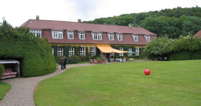
Obernfelde Manor (Lübbecke)

To be privately owned

The Obernfelde Estate is a former manor and stately home in the city of Lübbecke in the Minden-Lübbecke district.

The estate is located on the northern slope of the Wiehen Hills, 1.5 kilometers southwest of the center of Lübbecke, in the immediate vicinity of the Lübbecke Hospital.

The manor is first mentioned around 1540. In 1730, it came into the possession of the von Korff family, who provided several Minden district administrators in the 18th century. In 1818, Eberhard Freiherr von der Reck acquired the estate. It has remained in the ownership of his descendants to this day.

In autumn 2007, the estate provided the setting for the founding of the association "Manor Houses and Parks in the Mühlenkreis". Members of the association include the owners of historic properties and municipalities in the region. Elisabeth Freifrau von der Recke is a member of the association's board.

Buildings and Park+

The manor house and farm buildings are parallel to each other and form an elongated narrow courtyard. To the east of this and south of the hospital is the Ministerhaus, built according to plans by Karl Friedrich Schinkel.

The orangery, built between 1828 and 1829, served as a prisoner-of-war camp during World War II. It was converted into a residential building in 1980.

The parts of the park north of the orangery are no longer present, with the exception of individual old trees. Some lime trees in the area of the driveways to the manor house and the orangery are noteworthy. The remaining park essentially consists of a central lawn with individual flowerbeds. The well-maintained park is used only privately.

Current Use+

The estate is still managed. Some former buildings (for example, the mill and the orangery) are used for residential purposes. The estate is not publicly accessible.

Take Mobile History with you

You are reading this text for free. Premium adds what matters on the road: descriptions read aloud, sites found through your camera, whole regions taken offline.

  • Every description, including the ~17,700 Premium sites
  • Audio guide: have descriptions read to you on location
  • AR finder: see sites through your camera, with distance and bearing
  • Unlimited saved sites

14 days free, then from €2.99 a month. Cancel anytime.

Source: Wikipedia · Licence: CC BY-SA 4.0

This description draws on the facts documented in the linked Wikipedia article; Wikipedia content is licensed under CC BY-SA 4.0. Wording and editing: Mobile History.

Location: 52.2940, 8.6038