To be privately owned
ManorRerik-Roggow
Roggow Manor
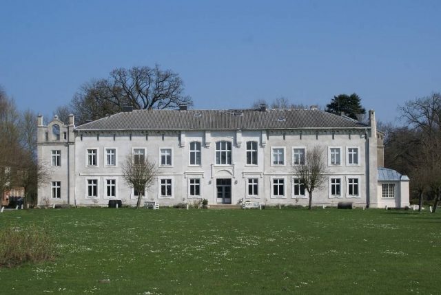
The Roggow Manor House in the municipality of Rerik in the district of Rostock in Mecklenburg-Vorpommern is a manor house built in the Tudor Gothic style from the mid-19th century.
About 60 meters east of the country road between Rerik and Neubukow, the Roggow Manor House is located in the middle of the village. 400 meters to the west lies the Salzhaff and 3.5 kilometers to the north is the seaside resort of Rerik.
The former Slavic castle complex was subsequently first mentioned as "Gut Roggow" in a document on June 28, 1345, with Hermann von Oertze van Rogghowe. However, it is assumed that the Oertzen family was already settled here much earlier. For centuries, the small, self-contained place was then a knight's estate of the von Oertzen family.
After severe destruction and devastation in the Thirty Years' War, the manor house was rebuilt around 1666 in the Baroque style. A plan of the courtyard complex from 1745 states that in addition to the residential house built in 1666 and the barn, the estate also included a stable, an outbuilding, two cattle sheds, and an arched bridge from 1736 onwards. The entire estate complex was surrounded by a water-filled moat. It could be crossed via a drawbridge, which was still in operation until 1835. A gatehouse adjoined the courtyard side. Of the former courtyard, today, besides the manor house, only the old pigsty located to the east - now a residential house - and a building located to the south still exist. The moat that surrounded the former moated castle has also disappeared, except for small remnants, making the original character of the entire complex difficult to recognize.
The manor house is of medium size. After several alterations and extensions, it was redesigned in 1850 in the Tudor Gothic style. In 1921, it was last rebuilt and brought into its current form, although its core is much older. The two-story plastered building with the shallow gable roof was rebuilt in Neo-Gothic style. Since the gables were removed after 1945, the facade appears somewhat asymmetrically structured. Of the twelve axes, the left one is pulled forward like a risalit and gabled with pinnacles. In the middle of the facade, there used to be a stepped dwarf gable.
Source: Wikipedia · Licence: CC BY-SA 4.0 · Image: Roland Neubert, Halle (Saale)
This description draws on the facts documented in the linked Wikipedia article; Wikipedia content is licensed under CC BY-SA 4.0. Wording and editing: Mobile History.
Location: 54.0755, 11.6346