CastleOrlamünde

Orlamünde Castle

Orlamünde Castle

Museum

The Kemenate Orlamünde is a remnant of a castle complex from the 11th and 12th centuries in Orlamünde, above the Saale valley between Jena and Rudolstadt. Orlamünde is the only Thuringian castle recorded on the Ebstorf World Map, created around 1300.

The first mention is found in a parish document from 1194, which refers to older sources before 1067. The castle was then in the possession of Count Otto I of Weimar.

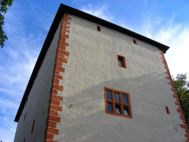
The Kemenate was the core building of the Orlamünde castle complex and is the last preserved building of the defensive complex, of which otherwise only parts of the ring wall and the gate system remain. It was one of the most powerful broad residential towers in Thuringia and blocked the entire ridge and thus the main attack side. The massive tower block has small and narrow loopholes and an entrance at a height of 9.5 meters. This strict castellated architectural style probably originated in Southern Italy and was adopted here. Later, further Kemenates were built in Thuringia.

The protracted inheritance dispute over the County of Weimar-Orlamünde was won by Hermann, the great-grandson of Count Otto of Weimar's daughter, who now called himself Count of Orlamünde. After the destruction of Weimar Castle, Orlamünde Castle became the main residence. Subsequently, the Counts of Orlamünde-Weimar rose to become temporarily the strongest ruling dynasty in Thuringia, which later, however, split into several lines. After a sale due to over-indebtedness in 1344, there were countless changes of ownership. The castle fell into disrepair and became a quarry for the population, so that only the Kemenate remained as the sole usable building.

With the end of the Middle Ages and the rise of the bourgeoisie, the remaining Kemenate was renovated by the city of Orlamünde. It was then used as a granary and warehouse. In the 20th century, it began to be used for advertising and leisure activities. As an event venue and club building for the local castle association, the Kemenate is once again extensively used, and a small local history museum has been established. Access is possible at certain times.

Take Mobile History with you

You are reading this text for free. Premium adds what matters on the road: descriptions read aloud, sites found through your camera, whole regions taken offline.

  • Every description, including the ~17,700 Premium sites
  • Audio guide: have descriptions read to you on location
  • AR finder: see sites through your camera, with distance and bearing
  • Unlimited saved sites

14 days free, then from €2.99 a month. Cancel anytime.

Source: Wikipedia · Licence: CC BY-SA 4.0 · Image: http://www.wehrbauten.de/thread.php?threadid=599

This description draws on the facts documented in the linked Wikipedia article; Wikipedia content is licensed under CC BY-SA 4.0. Wording and editing: Mobile History.

Location: 50.7771, 11.5282