ChurchEußenheim-Aschfeld

Aschfeld Church Castle

Aschfeld Church Castle

The church castle can be visited

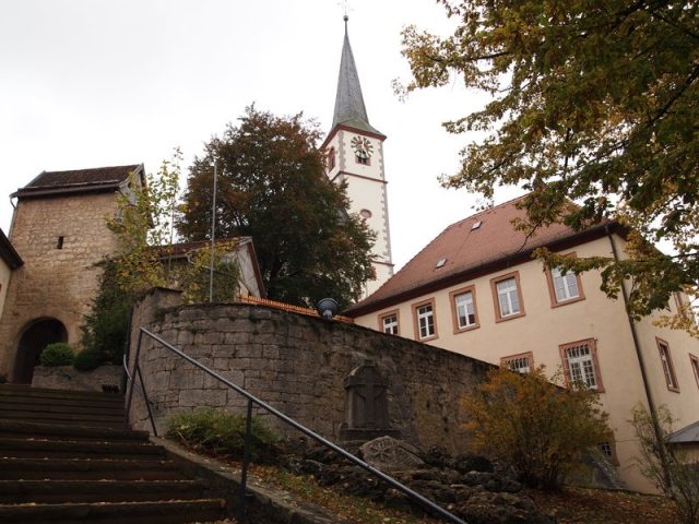
The historic fortified church in Aschfeld is situated on a rocky outcrop that drops steeply on three sides. The almost flat western side, the weak point of the fortress, was protected against attacks by a strong wall with loopholes. A square, squat tower guards the entrance. The fortified church served the citizens of Aschfeld as a refuge to protect themselves from wandering hordes of warriors. The last siege was during the Thirty Years' War. It has never been known that the Aschfeld fortified church was ever captured during a siege.

The fortified church, with St. Boniface Church and the cemetery in the middle, represented the so-called sacred district, which was particularly protected by unwritten law. If one asks why such a magnificent defensive structure was built in the small village of Aschfeld, the answer is quickly found: According to old records, it was probably the favorable traffic location, because Aschfeld was at that time at the intersection of two important traffic routes. A north-south connection, from Fulda-Hammelburg to Würzburg (today's Heerstraße), crossed in Aschfeld the equally old west-east connection, which probably led as a continuation of the "Birkenhainer Weg" via Büchold to Geldersheim. If you pass through the large gate under the defensive tower, you will see a pair of scissors carved into a stone on the left gaden wall. An old deed of gift states that in 1296 a small Beguine convent was established here. The Beguine convent had until then stood in the "Ispenkammer" field. The "Nonnenpfädchen" (Nun's Path) still leads to this field today.

After the fortified church was no longer used as a refuge, it served as a storage facility for the inhabitants of Aschfeld. Due to the steep staircase, it was very difficult to store potatoes and turnips, must and food in the 19 gaden and cellars. A driveway into the fortified church was only created by opening the western wall during the construction of the elementary school in 1922.

Take Mobile History with you

You are reading this text for free. Premium adds what matters on the road: descriptions read aloud, sites found through your camera, whole regions taken offline.

  • Every description, including the ~17,700 Premium sites
  • Audio guide: have descriptions read to you on location
  • AR finder: see sites through your camera, with distance and bearing
  • Unlimited saved sites

14 days free, then from €2.99 a month. Cancel anytime.

Source: Wikipedia · Licence: CC BY-SA 4.0 · Image: http://www.wehrbauten.de/thread.php?threadid=1240

This description draws on the facts documented in the linked Wikipedia article; Wikipedia content is licensed under CC BY-SA 4.0. Wording and editing: Mobile History.

Location: 50.0053, 9.8248