Municipal offices
CastleMarkt Einersheim
Kirchenburg Einersheim (Fortified Church)
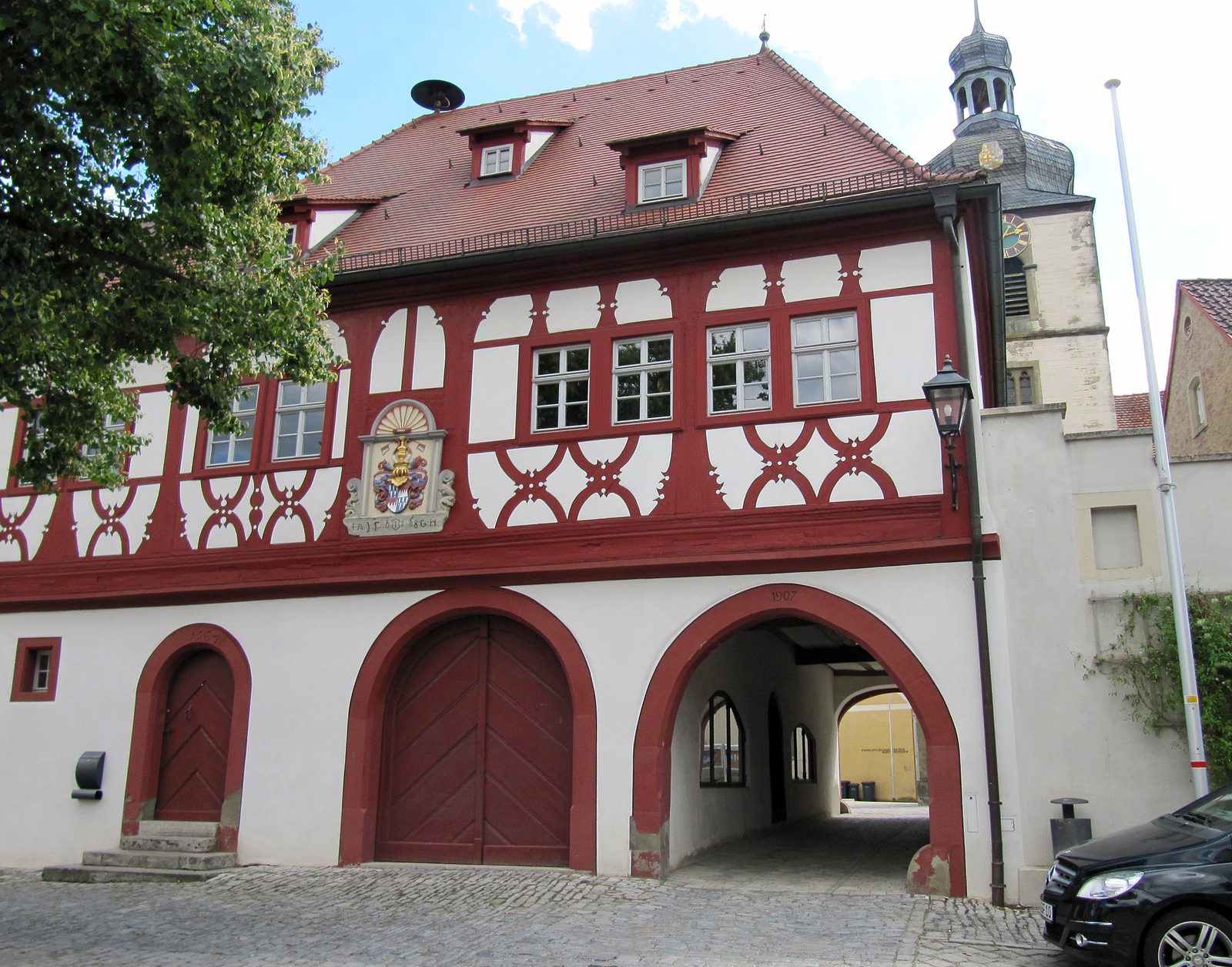
The fortified church of Einersheim (also fortified church of Markt Einersheim) comprises the fortified areas of the churchyard around the Protestant parish church of St. Matthew in Markt Einersheim, Lower Franconia.
The fortified church is centrally located in the old town of Einersheim, forming its focal point. It is surrounded by the streets Marktplatz, Schockengasse, Frankenbergstraße, and Am See. The complex was built on a hill spur that slopes steeply to the southeast. This hillside location caused a kink in the surrounding wall on this side. The fortified church of Einersheim is part of the architectural ensemble of the village center of Markt Einersheim.
History+
The fortified church of Einersheim was first mentioned in 1414. At that time, one had to pass through a gate tower to enter the churchyard. There was already the predecessor building of the parish church. In general, fortified churches date back to the military threats of the Middle Ages. While cities and wealthier villages surrounded themselves with a ring wall, poorer communities only fortified the churchyard, which also served as a cemetery in earlier times. The complex in its current form was built no later than the 16th century. The gatehouse was replaced between 1567 and 1568 by a representative half-timbered house with a gate passage, which still forms the access to the fortified church from the market square today. The coat of arms of the Schenken von Limpurg on this building refers to their lordship over Einersheim. The oldest gaden (storage houses) in the inner courtyard of the complex are marked with the year "1596". There, the inhabitants of Einersheim stored their provisions in times of peace. In the years 1734 and 1735, the surrounding wall of the fortified church was renewed, although this defensive structure had long since lost its defensive function with the advent of large cannons in the 17th century. In the following centuries, large parts of the complex were rebuilt, so that only a few remnants still recall the former fortified church. In 1945, American tank shelling in the last days of World War II destroyed further buildings of the fortification. The subterranean remains of the fortified church are classified as an archaeological monument.
Description+
St. Matthew's Church+
Einersheim's St. Matthew's Church is located in the middle of the fortified church. It is considered one of the oldest churches in the area and served a huge parish in the Middle Ages. The lords of Einersheim, the Schenken von Limpurg-Speckfeld, introduced the Reformation in the 16th century and rebuilt the church in the 17th century. In 1700, the distinctive tower was raised, which also served as a viewpoint for the fortified church and had a battlement. St. Matthew is an east-facing choir tower church. The oldest parts of the building date back to the Romanesque period, a time when the fortified church probably did not yet exist. The nave has five bays, making it longer than many other churches in the area. Inside the church is a walled-up crypt where members of the Schenken family were buried. Most of the gravestones are displayed in the inner courtyard of the fortified church.
Town Hall, Charnel House, Defensive Wall and Epitaphs+
Due to the destructions since the 18th century, only a few remnants of the former fortified church have been preserved. Particularly impressive is the current town hall of the municipality, which also serves as a gatehouse and entrance to the churchyard fortification. It is a two-story hip-roofed building with ornamental half-timbering on the upper floor. The coat of arms of the Schenken von Limpurg-Speckfeld proudly adorns the market square side. The former soul mass chapel, which also served as a charnel house or ossuary for the community, has been heavily altered and is used as a garage. Only a few gaden houses have survived. Originally, they probably extended around the churchyard; the cellars of these houses still partially exist. On the west side, remnants of the defensive wall, about 2 m high, still stand. In the inner courtyard, five gravestones from the church crypt are displayed. They are largely weathered and mostly bear the coats of arms of the Schenken. Originally, the fortified church had two entrances: the town hall passage and the so-called Klein-Kirchtörlein (small church gate) in the south.
Take Mobile History with you
You are reading this text for free. Premium adds what matters on the road: descriptions read aloud, sites found through your camera, whole regions taken offline.
- Every description, including the ~17,700 Premium sites
- Audio guide: have descriptions read to you on location
- AR finder: see sites through your camera, with distance and bearing
- Unlimited saved sites
14 days free, then from €2.99 a month. Cancel anytime.
Source: Wikipedia · Licence: CC BY-SA 4.0 · Image: Irmgard (Sucomo) ( Diskussion ) · Wikimedia Commons · CC BY-SA 3.0
This description is a machine translation of an excerpt from the linked Wikipedia article. The source text was written by its authors, the translation is by Mobile History; like the original it is licensed under CC BY-SA 4.0.
Location: 49.6869, 10.2926