CastleOstheim v. d. Rhön

Church Castle Ostheim
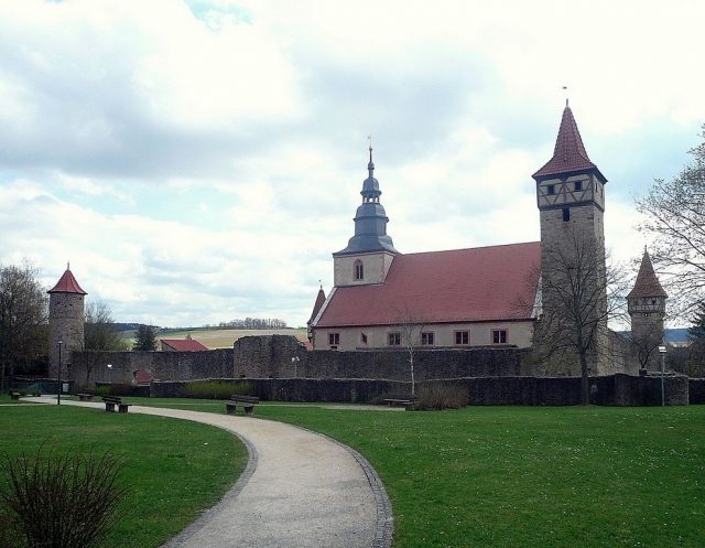
Church Castle Ostheim

Museum

The fortified church of Ostheim is a Kirchenburg (fortified church) in the Lower Franconian town of Ostheim vor der Rhön in the district of Rhön-Grabfeld. The local town church of St. Michael is located within a double ring wall, built between 1400 and 1450, with an intermediate bailey. The double ring wall features five defensive towers and is reinforced with six bastions at half its length. The Protestant church, built in Renaissance style on the foundations of a predecessor church, dates from 1615 to 1619. Within the fortification are 66 vaulted cellars with 72 Gaden (storage houses), which served as shelters during armed conflicts and where local residents stored their belongings safely in times of crisis. With a footprint of 75 by 75 meters, it is considered the largest and best-preserved fortified church in Germany. Some of the vaulted cellars are still used by the local population as storage cellars.

The fortified church is located on the northern edge of Ostheim. It stands on a plain that slopes gently southwards towards the Streu, a right tributary of the Franconian Saale. Situated at an altitude of 310 meters above sea level, it towers over the town by about 10 to 15 meters. It stands in the border region between the former dominions of the Bishops of Würzburg in the south, the Abbots of Fulda in the west, and the Counts of Henneberg in the north. During armed conflicts, the population found safe refuge in the fortified church. It stands directly on the trade route, the Ortesweg, which was already in use during Celtic times, as well as on the Hohe Straße, the historic long-distance road from Fulda to Bamberg.

Significance+

With an area of approximately 0.6 hectares, the fortified church is one of the largest fortified churches in Germany. Comparable complexes, such as the fortified churches in Walldorf and Rohr in Thuringia, cover about 0.3 to 0.4 hectares. Like no other fortified church in Germany, it is surrounded by a double ring wall with an intermediate bailey and several towers and bastions. The fortified church is preserved except for the southwest side; all vaulted cellars and Gaden are still accessible. In 2003, the fortified church was declared a monument of national importance.

Ostheim, with its fortified church, and the surrounding region were located in a territorially fragmented area with frequent changes of ownership. From 1409, they belonged to the Archbishopric of Mainz, and from 1423 to 1433, to the Prince-Bishopric of Würzburg. In 1433, the Counts of Henneberg-Römhild took over the Ostheim area, and from 1548, the Counts of Mansfeld. From 1555, the Dukes of Saxony ruled there, and from 1741, the Dukes of Saxe-Weimar-Eisenach. In 1920, Ostheim became part of the state of Thuringia, and in 1945, of Bavaria. Since 1410, it has been ecclesiastically independent and received town rights in 1596. The nobility could retreat to Lichtenburg, located two kilometers north, during armed conflicts. The urban population in other places found protection behind a city wall, while the residents of Ostheim were exposed to the dangers of war without protection. The people of Ostheim therefore protected themselves by reinforcing and expanding the church. The construction of the fortified church took place without the support of spiritual and secular lords, and its later maintenance was also exclusively undertaken by the citizens and farmers of Ostheim.

The first church, Beatae Mariae Virginis, was completed in 1419. From a defensive perspective, it was located in an unfavorable position, as it was surrounded by flat terrain. To protect it, a first wall was built around the churchyard starting in 1417/1418. By 1450, a defensive wall with tall, slender defensive towers at the corners was erected. During the Hussite invasions in the 1430s, an additional bailey and another outer wall were built. In 1579 and 1580, the complex was further expanded due to the Turkish threat. A complete tower-fortified outer wall with the intermediate bailey was created. Loop-holes for arquebuses were installed in the towers of the inner wall. The north side was reinforced by another, centrally located round tower.

Between 1589 and 1620, a new church was built on the same site, as the previous one had become too small for the town's population. In 1634, during the Croatian invasion in the Thirty Years' War, armed conflicts occurred. Ten citizens defended the fortified church with arquebuses but had to surrender the castle to prevent the town from being burned down. The fortified church was plundered but not destroyed.

Within the fortification walls are storage houses (Gaden) with underlying vaulted cellars, mostly with arched doors, some of which are marked with years. This allows individual Gaden to be dated to 1547, 1575, 1576, 1855, and 1864. The connection of the Gaden to the outside of the inner wall created an additional continuous protective wall. Most Gaden consist of brick cellars with barrel vaults and hut-like superstructures above them. The ground floors are mostly built of rubble stone, while the upper floors are half-timbered. In the Gaden, turnips, fruit, must, from about 1780 potatoes, and sometimes valuables were stored. As the Gaden underwent numerous alterations and extensions over time, the ridges have uneven heights and the roofs are covered differently. As part of building renovations and preservation, the Gaden were partially standardized.

Since the fortified church had lost its military significance in the course of the 19th century, it was no longer expanded but only renovated. In the 19th century, a breakthrough was made in both northern wall sections of the church as an additional access point. During the great town fire in 1878, the fortified church was also damaged. In 1935 and 1936, the wooden tower rooms of the corner towers were renewed. Church renovations were carried out in 1960 and 1961. During this time, the ceiling painting was colorfully reconstructed; the wall frescoes on the south and west sides were uncovered. On the east side, two small, superimposed galleries were removed, and the paint on the balustrades of the other galleries was renewed.

After the acquisition of the Gaden by the town of Ostheim, the fortified church was extensively renovated in 1982. Further thorough renovations of the fortified church and the church were carried out in 2002 and 2003. In the summer of 2008, the "Lebendige Kirchenburg" (Living Fortified Church) Museum was opened opposite the entrance gate. It displays the history of the Ostheim fortified church and other fortified churches in the Franconian and Thuringian regions on three floors.

Description+

The fortified church is surrounded by two rings of walls and has a rectangular floor plan. The inner area measures 60 by 60 meters and is enclosed by a six to eight-meter-high wall. At each corner of the wall ring, there is an approximately 25-meter-high corner tower. The two eastern towers are round, while the two western towers have a rectangular floor plan. The towers are each 66 meters apart. In the middle of the northern boundary wall, there is a round bastion for reinforcement. A 7.5-meter-wide bailey runs around the inner wall. The outer wall is five meters high, has tower-like corner bastions, and another bastion on each of the long sides. A round bastion on the east side of the outer wall is no longer preserved. At the southwestern corner, there is a fifth defensive tower. A sixth defensive tower at the southeastern corner of the outer wall has also not been preserved. Foundations of this tower were found during construction work in 1911. The part of the eastern wall connected to the tower was also demolished.

Within the bailey were battlements, which are only preserved on the south side. The defensive walls made of rubble stone are plastered in places. During the construction of the fortified church, bows and crossbows were used for combat, so vertical slit embrasures were installed for crossbowmen. Horizontal loop-holes were later used for firearms. However, the military utility of the complex increasingly receded into the background.

The partially preserved city fortification walls adjoin the outer walls. The fortified church was accessible at the southeast corner through a round-arched entrance gate with a portcullis. In front of it was a fortification ditch that enclosed the entire complex. In later years, the ditch was filled in, and another access from outside was broken through the northern wall sections.

The Gaden of the fortified church are predominantly located close to the inside of the inner wall belt; in the northern and eastern parts, they also stand freely. They have one to two stories and are accessible through partly narrow alleys and over several stairs. South of the fortified church are cellars, partly vaulted, partly hewn into the rock, which extend under the southern bailey. In the event of impending attacks, the residents of Ostheim retreated with their most important belongings, provisions, and some livestock into the fortified church, where they found temporary protection. The cellars and Gaden accommodated people, livestock, and provisions. In times of peace, they served for storage, with usually one Gaden with a cellar owned by a family. Sometimes several families shared a Gaden complex. In the cellars, temperatures remained almost constant in summer and winter. This kept stored goods fresh for a long time. After the harvest, grain, hay, must, turnips, or wine were stored. Wine and fruits went into the dark, evenly tempered cellars, hay and grain into the upper floors.

In the middle of the fortified church complex stands the town parish church. Next to the gatehouse is the former churchyard school, which today houses a natural history museum. The entrance gate of the fortified church is located near the southeastern corner on the eastern wall within the Ostheim city wall. The round-arched gate is still preserved in its original state. On an iron-clad gate wing, which also has a small door opening for pedestrian traffic, it bears the year 1622. Hook stones served a retractable portcullis. In the 16th century, the churchyard school was a Latin school, later a girls' school. The teacher's apartment was on the half-timbered floor. It is documented that the building was used as the Ostheim school since the mid-16th century. In the 19th century, the building was rebuilt several times. Around 1980, the building was last rebuilt and thoroughly renovated. Today, changing exhibitions are shown there. The Steingaden was added to the defensive wall in 1466 and 1467 and is part of the extensive Gaden and cellar complexes within the fortification. The building, constructed of rubble stone, has two round-arched portals and several slit windows and was rebuilt in 1560 and 1664.

Church

The old church from the 15th century, which had been walled in on the east, west, and north in 1589, was demolished in 1615, except for the tower. The current church was built on the same site from 1615 to 1620. It is one of the earliest Protestant town churches in Central Germany. The tower on the east side, which sits on the nave, was built in 1579 and 1580 and replaced a predecessor with a wooden superstructure on the same site. The tower bears one of the earliest Welsche Hauben (Baroque domes) in the region, has pointed arched windows, and overtops the fortification towers. Two ashlar stones on the southeast corner of the tower floor bear the year 1579 and the names of the pastor Johann Schultheiß, who served from 1575 to 1591, and the mayor Conrad Zinn. Both are depicted facing each other in profile on the south facade of the church.

The rectangular building has a gable roof over three naves. The exterior walls of the church were initially regularly plastered with ashlar blocks. Inside, the western gallery was rebuilt several times and renewed in 1975 according to historical models. In 1695, major restoration work was carried out. In 1738, the church received new windows; the galleries were painted white. After the city fire of 1878, the church was extensively renovated in 1881 and last extensively restored in 2002 and 2003.

The large wooden barrel vault was adorned in 1619 by Nicolaus Storant from Meiningen with a ceiling painting, painted directly onto the wood. It depicts the heavenly throne of God, as described in Revelation, chapters 4 and 5. Also from 1619 is a stone alms box by Hans Markert. On the northern long side and on the back side are two superimposed, seated galleries aligned with the pulpit featuring the four Evangelists. The church interior, including the galleries, has over 1000 seats. The main entrance of the church on the south side, from 1616, is sumptuously designed in Renaissance style. The east portal, also in Renaissance style with an obelisk, dates from 1615. On the south wall, Christian scenes in grisaille are arranged around the windows, depicting God's love, faithfulness, and care, Cain and Abel, David, and Goliath. Gravestones are affixed to the walls, which were rearranged between 1961 and 1975. A Baron von Stein is buried in the crypt under the choir.

During the Thirty Years' War, the older church bells were melted down. Traveling Lorraine bell founders cast two bells for the town church in 1645, one bearing the town's coat of arms and the other the names of Ostheim's two clerics and the donor. In 1714, the large bell cracked and was recast by Mattheus Ulrich. He incorporated the names of the reigning Duke of Saxony as well as officials and clerics.

The organ in the choir area is by Johann Ernst Döring from 1738. From 1894 to 1975, it stood on the extended western gallery. When it was moved back to the choir area in 1975, two laterally attached tower superstructures from 1894 were removed from the casing. The organ has two manuals and a total of 37 stops. The casing was repainted and gilded with its former colors. The organ mechanism was renovated as part of the relocation by organ builder Otto Hoffmann and Sons. In the center is the ducal Saxon coat of arms with two gilded lions as supporters and above it the cymbal star. Below it stands a trombone angel with movable arms, which was newly gilded during the renovation. The two large leaf-scroll frames were also newly carved. A special feature is that when the Trompete 8' stop in the main work is activated, a mechanism is set in motion, causing the angel figure below the escutcheon to raise the trumpet to its mouth. The choir organ can also be played from the main organ.

Towers

There are four towers on the inner encircling wall. The round school bell tower at the southeast corner, with a high entrance on the second floor, comprises five stories. Due to its location at what was formerly the only access, it held greater importance. It was built in two construction phases. The tower shaft dates from 1417 and 1418. The upper tower room and the attic were built after 1426. The tower formerly housed the school bell, from which it gets its name. It is 26 meters high and, at over five meters, has the largest diameter of all the castle's towers.

The Eight-Hole Tower at the northwest corner gets its name from the eight windows in the half-timbered upper floor. It is 22 meters high and has six stories, of which the lower five are solidly built of rubble stone. Each floor, accessible by a ladder, contains a single room. The lower floors, with an almost square footprint, were built in 1417 and 1418. The tower room was completed in 1666, according to an inscription. In 1935, the half-timbered walls were renewed.

The Waagglockenturm (Weighing Bell Tower) with a rectangular floor plan and bossed ashlar at the corners stands at the southwest corner. The outer dimensions of the tower are approximately 4.5 by 4.8 meters. The lower five stories are built of rubble stone, while the upper third consists of half-timbering. The half-timbered upper floor has a bell bay, and the roof is octagonal. The construction year of the tower is unknown. The spire and the tower room date from after 1436. The tower formerly housed the town scales, from which its name is derived. It is known from 1618 that the tower had a clock. By means of an iron clockwork, the bell struck hourly, and the time was displayed on a large dial. The bell, which hangs in a renewed hatch from 1739, also served as a fire bell and as a signal that the town scales could be used. Therefore, the tower was formerly also called Schlagturm (Striking Tower). The Waagglockenturm, at 26.5 meters and six stories, is the highest of the fortified church. It can be climbed as an observation tower.

The round Pulverturm (Powder Tower) at the northeast corner has a height of 16.5 meters and a diameter of approximately 4.5 meters. The massive tower is integrated into the inner eastern and northern bailey walls and is accessible via a battlement. The varying wall structure of rubble stone over three stories is striking. It was already referred to as a powder tower in a town account in 1642. However, there is no evidence that it served as a storage place for gunpowder. The construction year is unknown. The tower is said to have been rebuilt in 1664 after the damage in the Thirty Years' War.

The round Wächterturm (Watchman's Tower), also called Zwingerturm (Bailey Tower), stands near the Waagglockenturm at the southwestern corner of the outer wall. It is the only preserved tower on the outer encircling wall and has a subsequently added half-timbered upper floor and an octagonal tent roof. The tower has three stories and a basement. Its height is 11.75 meters. Access is via a wooden staircase on the upper floor. Inside, another staircase leads to the second upper floor with two small rooms and a larger one, which served as sleeping and living quarters. From the 17th to the 19th century, the fire and night watchman lived there. In the 20th century, the tower was temporarily named Kißlingsturm after a man named Kißling who lived there.

Take Mobile History with you

You are reading this text for free. Premium adds what matters on the road: descriptions read aloud, sites found through your camera, whole regions taken offline.

  • Every description, including the ~17,700 Premium sites
  • Audio guide: have descriptions read to you on location
  • AR finder: see sites through your camera, with distance and bearing
  • Unlimited saved sites

14 days free, then from €2.99 a month. Cancel anytime.

Source: Wikipedia · Licence: CC BY-SA 4.0

This description draws on the facts documented in the linked Wikipedia article; Wikipedia content is licensed under CC BY-SA 4.0. Wording and editing: Mobile History.

Location: 50.4596, 10.2317