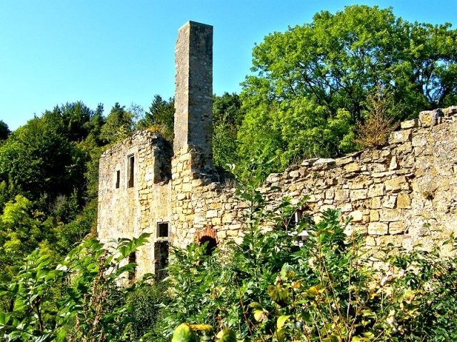
The Ruin can be visited
Ober-Werbe Abbey (Ruin)

The monastery ruin of Ober-Werbe is located above the village of Ober-Werbe, a district of the town of Waldeck. The remains of the Romanesque building stand on a limestone cliff where peregrine falcons breed and which offers a wide view over the village and its surroundings. The monastery ruin is considered one of the most charming in the Waldecker Land.
The Werbe monastery is said to have existed as early as 1038. However, the first documented mentions are only found in the years 1124/1125, when Pope Honorius II took the monastery, dedicated to Saint Mary and Peter, under his protection. Initially, the monastery was a Benedictine monks' convent. In 1155, Pope Hadrian IV handed Ober-Werbe over to Corvey Abbey. By 1207 at the latest, it was a Benedictine nuns' monastery. In 1494, nuns from Vinnenberg Abbey near Warendorf were sent to Werbe to enforce the monastic reform according to the rules of the Bursfelde Congregation.
After the introduction of the Reformation in the County of Waldeck in 1525/1526, Count Philipp IV of Waldeck-Wildungen dissolved the monastery in 1537, and the inhabitants were compensated. The last abbess married the first Protestant pastor in Ober-Werbe, the preacher Kaspar Jäger, in 1535. Count Philipp sold the entire complex, the so-called "Haus Werbe", with all its appurtenances, tithes, revenues, and mills on May 5, 1553, for 3800 gold guilders and 1200 Joachimsthaler to Wilhelm Wolff von Gudenberg, who also took on the obligation to provide for the four remaining monastic persons and to fill the parish. However, when he died only a few months later, his widow Margarete pledged Haus Werbe to Samuel von Waldeck, son of Count Philipp IV, on September 29, 1553. In 1564, the Landgrave-Hessian councilor Simon Bing acquired Haus Werbe with all its appurtenances by pledge. Five years later, on May 1, 1569, he ceded it back to Count Philipp IV of Waldeck-Wildungen after the pledge was redeemed. From 1578 onwards, the former monastery was a count's dairy farm, which was moved to the valley in 1640.
After the Thirty Years' War, a gradual decay began, and most of the monastery buildings were eventually demolished or used as building material for new constructions in the village.
The Church+
The church in the valley represents the origin of the monastery on the rock above the village. Only at a later point did the monastery move to the rock, the Langen Stein. Presumably not entirely, which caused a spatial separation of the institution; the church in the valley remained the monastery church. This relocation of the monastery is unique in the Waldecker Land. Why this happened is unclear. Reasons for the monastery's move could have been the unstable ground of the church in the valley or the fact that the location on the hill was better suited for defense.
Take Mobile History with you
You are reading this text for free. Premium adds what matters on the road: descriptions read aloud, sites found through your camera, whole regions taken offline.
- Every description, including the ~17,700 Premium sites
- Audio guide: have descriptions read to you on location
- AR finder: see sites through your camera, with distance and bearing
- Unlimited saved sites
14 days free, then from €2.99 a month. Cancel anytime.
Source: Wikipedia · Licence: CC BY-SA 4.0
This description draws on the facts documented in the linked Wikipedia article; Wikipedia content is licensed under CC BY-SA 4.0. Wording and editing: Mobile History.
Location: 51.2272, 8.9818