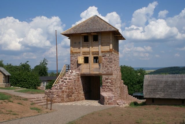
The remains of the Castle can be visited
Tilleda Castle

The Royal Palace of Tilleda was a medieval royal palace below the Kyffhäuser on the southern edge of the Harz mountains. Today, the complex is an open-air museum in the village of Tilleda. It is the only fully excavated palace in Germany and is a stop on the Romanesque Road.
The area on the Pfingstberg was settled at various times in prehistoric and early historical periods, particularly intensively in the late Bronze Age. The oldest evidence of early medieval settlement dates back to around 700, with finds indicating that wealthy individuals lived here.
At the beginning of the 9th century, the place was first mentioned in a document in the "Breviarium Lulli". A possible derivation of the place name from "Palisade" would suggest that the oldest fortification dates back to this period. In the marriage certificate of Empress Theophanu, Tilleda is referred to as an "imperial court", i.e. a palace, in 972 and transferred to her as a widow's estate. Between 974 and 1042, "Tullide" appears as the place of issue for documents by Emperors Otto II, Otto III, Conrad II, and Henry III. During the Salian period, the main castle, in particular, underwent significant changes.
In the 11th century, the palace lost its military significance and was replaced by the new castles on the Kyffhäuser. However, the royal demesne, which was still operated here, was expanded even in the 12th century. Among other things, a manufactory-like cloth production was established. For a short time, the main castle was fortified again, but rather provisionally.
In 1174, Emperor Frederick I Barbarossa gathered an army here, which he needed for his intended campaign to Upper Italy against the city of Alessandria. In 1194, King Henry VI reconciled with Duke Henry the Lion in the palace, thereby settling the long-standing dispute between the Staufer and Welfs.
After 1194, the Palace of Tilleda is no longer mentioned in written sources. However, various finds, including those from the knightly milieu, prove that the complex was still in use. The palace was completely abandoned before the end of the 12th century.
From the 14th to the 20th century, the Pfingstberg was used for agriculture. The ruins, which were in the way, were gradually removed over time. Only minor indications of the ramparts and ditches, as well as two small wall remnants, remained. In 1871, these topographical features were first interpreted again as remnants of the palace.
Between 1935 and 1939, the first archaeological excavations were carried out on the palace grounds under the direction of Paul Grimm. The investigations were resumed in 1958, and the palace was completely excavated by 1979, with the exception of a few control areas.
Open-Air Museum+
In 2001, the municipality of Tilleda transformed the palace area into an open-air museum. In addition to guided tours for groups, it offers the following museum educational programs:
- History Rally as a more entertaining tour of the Royal Palace
- Archaeology live
- Medieval games
- Nutrition in the Middle Ages with the preparation of smaller dishes
- Medieval textile crafts
- Pottery of medieval toy figures
- Surveying on the High Medieval construction site
- Medieval building techniques
- The medieval scriptorium
- Medieval music
- Medieval hunting with archery
- Medieval warfare and weapon practice (tournament)
In addition, an experimental weekend for medieval groups takes place in autumn. For visitors, there are various event offerings, with the highlight being the annual "Knight's Festival" in July.
Take Mobile History with you
You are reading this text for free. Premium adds what matters on the road: descriptions read aloud, sites found through your camera, whole regions taken offline.
- Every description, including the ~17,700 Premium sites
- Audio guide: have descriptions read to you on location
- AR finder: see sites through your camera, with distance and bearing
- Unlimited saved sites
14 days free, then from €2.99 a month. Cancel anytime.
Source: Wikipedia · Licence: CC BY-SA 4.0 · Image: Roland Neubert, Halle (Saale)
This description draws on the facts documented in the linked Wikipedia article; Wikipedia content is licensed under CC BY-SA 4.0. Wording and editing: Mobile History.
Location: 51.4169, 11.1361