The remains of the Castle can be visited
FortressGadot (גָּדוֹת)
Crusader Castle Chastellet du Gué de Jacob
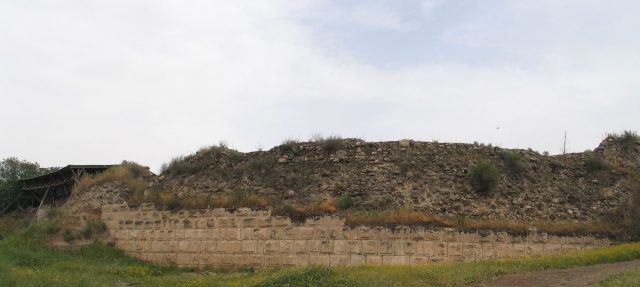
The Crusader castle Chastellet du Gué de Jacob is located in present-day Israel. It was built on the west bank of the Jordan River and served the Crusaders as a bulwark to secure their northern flank and exert pressure on Damascus.
History+
Following a victory over Sultan Saladin in November 1177, King Baldwin IV of Jerusalem began construction of the fortress at Jacob's Ford, a Jordan crossing, in October 1178. The castle was intended to protect the northern border of the Kingdom of Jerusalem. By April 1179, the first construction phase was completed, and a garrison of the Knights Templar occupied the site. Saladin tried to halt construction with monetary offers, which Baldwin rejected. By summer 1179, the castle featured a ten-meter-high curtain wall and a tower. Saladin besieged the fortress and, after a six-day siege, managed to capture it on August 30, 1179, by undermining its walls. King Baldwin arrived too late with his relief army, and Saladin subsequently had the castle destroyed.
Location+
The ruins of the Chastellet du Gué de Jacob fortress are situated in Gadot, in the northern district of Israel, at an elevation of approximately 77 meters above sea level.
On site+
The remains of the fortress, including excavated ditches and parts of the rectangular foundation wall, are now accessible as ruins. No traces of towers were found during excavations starting in 1993.
Take Mobile History with you
You are reading this text for free. Premium adds what matters on the road: descriptions read aloud, sites found through your camera, whole regions taken offline.
- Every description, including the ~17,700 Premium sites
- Audio guide: have descriptions read to you on location
- AR finder: see sites through your camera, with distance and bearing
- Unlimited saved sites
14 days free, then from €2.99 a month. Cancel anytime.
Source: Wikipedia · Licence: CC BY-SA 4.0 · Image: http://commons.wikimedia.org/wiki/File:Ateret-S-164.jpg
This description draws on the facts documented in the linked Wikipedia article; Wikipedia content is licensed under CC BY-SA 4.0. Wording and editing: Mobile History.
Location: 33.0045, 35.6279