The remains of the fortress can be visited
FortressJericho (أريحا)
Crusader Castle Maldouin
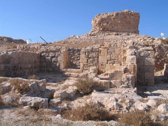
The Crusader castle Maldouin, also known as Castrum Dumi or Cisterne rouge, is a historic fortress whose ruins are located between Jericho and Jerusalem in the Palestinian Territories.
History+
The fortress of Maldouin was constructed in the mid-12th century by the Knights Templar. Its purpose was to protect the road connecting Jerusalem and the Jordan River, used by Christian pilgrims traveling to the baptism site of Jesus near Jericho. It is believed that the Templars utilized remnants of an existing Roman structure during its construction. The castle, situated on a hill, provided a resting place for pilgrims in the arid region and had water reserves, including a cistern that remains to this day. Following the Battle of Hattin in 1187, the castle was abandoned by the Templars and subsequently occupied by the Ayyubids, who, however, made no structural alterations. During the Barons' Crusade, Maldouin briefly returned to Crusader possession around 1241.
Location+
The Crusader castle Maldouin is situated in the Jericho region of the West Bank in the Palestinian Territories, at an elevation of approximately 279 m above sea level.
Take Mobile History with you
You are reading this text for free. Premium adds what matters on the road: descriptions read aloud, sites found through your camera, whole regions taken offline.
- Every description, including the ~17,700 Premium sites
- Audio guide: have descriptions read to you on location
- AR finder: see sites through your camera, with distance and bearing
- Unlimited saved sites
14 days free, then from €2.99 a month. Cancel anytime.
Source: Wikipedia · Licence: CC BY-SA 4.0 · Image: http://commons.wikimedia.org/wiki/File:Maldoim-699.jpg?uselang=de
This description draws on the facts documented in the linked Wikipedia article; Wikipedia content is licensed under CC BY-SA 4.0. Wording and editing: Mobile History.
Location: 31.8176, 35.3614