The remains of the Castle can be visited
FortressMi'ilya (מִעִלְיָא, معليا)
Crusader Castle Montfort (מבצר המוֹנפוֹר)
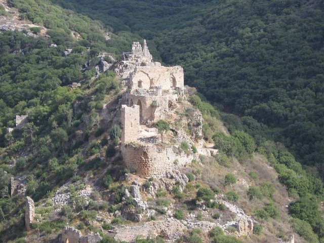
The Crusader castle of Montfort, a former fortress, is on a rocky spur in the mountains of Galilee in northern Israel. Its Arabic name “Qal'at Qurein” translates to “Castle of the Little Horn.” It was a stronghold of the Crusaders.
History+
The origins of Montfort Castle date back to the early 13th century, when the Teutonic Order acquired the inheritance of Joscelin of Courtenay. The goal was to establish a dominion that required a fortified administrative center. Since Castellum Regis in the plain was considered outdated, groundwork for a new Order headquarters began around 1226. The main expansion of the complex took place from 1228/29, supported by Grand Master Hermann von Salza, who was able to expand the castle through donations and gave it the German name “Starkenburg.” By around 1240, construction was largely complete. Montfort served as part of the defense system around Acre, then the capital of the Crusader Kingdom of Jerusalem. After an unsuccessful siege attempt in 1266, Mamluk Sultan Baibars I conquered the castle in 1271 after a 15-day siege. The Mamluks destroyed the fortifications to prevent reconquest. The chronicler Burchard of Mount Zion described Montfort as “completely destroyed” in 1283.
Location+
The Crusader castle of Montfort is in the North District of Israel, near the village of Mi'ilya. It is at an elevation of approximately 266 meters above sea level in the mountains of Galilee.
On site+
The ruins of the Crusader castle of Montfort are now accessible to visitors. Although large parts were destroyed, structures such as the front tower and the foundation walls of ancillary buildings are still preserved.
Take Mobile History with you
You are reading this text for free. Premium adds what matters on the road: descriptions read aloud, sites found through your camera, whole regions taken offline.
- Every description, including the ~17,700 Premium sites
- Audio guide: have descriptions read to you on location
- AR finder: see sites through your camera, with distance and bearing
- Unlimited saved sites
14 days free, then from €2.99 a month. Cancel anytime.
Source: Wikipedia · Licence: CC BY-SA 4.0 · Image: http://commons.wikimedia.org/wiki/File:PikiWiki_Israel_2885_Gelil_1963_%D7%AA%D7%9E%D7%95%D7%A0%D7%AA_%D7%9E%D7%97%D7%96%D7%95%D7%A8_%D7%9E%D7%90%D7%99%D7%9E%D7%95%D7%9F_%D7%92%D7%93%D7%A0%D7%A2_%D7%91%D7%92%D7%9C%D7%99%D7%9C_%28%D7%92%D7%9C%D7%99%D7%9C_%D7%99%D7%9
This description draws on the facts documented in the linked Wikipedia article; Wikipedia content is licensed under CC BY-SA 4.0. Wording and editing: Mobile History.
Location: 33.0445, 35.2262