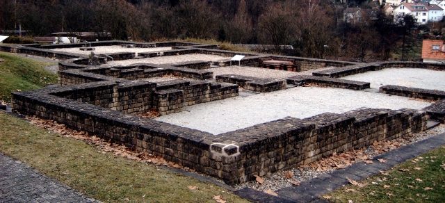
The roman Bath can be visited
Roman Bath Castle Schirenhof

The Schirenhof fort, also known as Etzelsburg, is a former Roman cohort fort located today in the urban area of Schwäbisch Gmünd, on the fields of Schirenhof in the Ostalbkreis district, Baden-Württemberg. It was built around 150 AD on a spur overlooking the Rems river towards the Raetian Limes behind it, which was declared a UNESCO World Heritage Site in 2005.
The well-chosen site of this ancient fortification, founded on the soil of the Roman province of Raetia, is located halfway up a southeast-northwest oriented mountain spur above the Rems. On the opposite side of the valley, about one kilometer away in a northwesterly direction, was the small fort of Freimühle, which was also situated on a small spur at the eastern exit of the Rotenbachtal valley. If one travels another kilometer from this small fort across the Rotenbachtal valley to the northwest up a steep slope, one reaches another ancient military site, the small fort of Kleindeinbach, already built in the territory of the Roman province of Germania superior, which was about 50 meters from the wooden palisade of the Limes. Just a few meters east of this small complex, descending into the Rotenbachtal, the province of Raetia began with the Raetian stone wall, which stretched to the Danube. Dendrochronological investigations in this valley have been able to determine an exact construction date. The timbers processed there were felled in the winter of 163/164 and built in 164. However, it is not entirely clear whether the wood recovered there actually came from the palisade and not from a bridge located shortly behind it. The border area of Germania superior and Raetia was unusually densely occupied with Roman military bases in the Limes area. The proximity of the cohort forts of Lorch on the edge of the province of Germania superior and Schirenhof in Raetia also seems to confirm this impression. Both are only about seven kilometers apart. Perhaps a certain independent action of those responsible for provincial administration becomes visible here. Especially the expansion of the imperial border in stone, carried out only in Raetia, could be evidence for this.
Research History+
Already at the end of the 14th century, the name "Etzelsburg" is attested for the fort. The walls, still standing at that time, were associated with Attila, the king of the Huns, who lived on as King Etzel, among other things, through the Nibelungenlied.
From a Baroque chronicler of the city of Schwäbisch Gmünd, the councilor Friedrich Vogt (1623–1674), it is known that the "castle" was called "Etzelburg" in old writings. But already in Vogt's time, the remains had been completely removed as a cheap quarry. Only parts of the ditch system were apparently still visible then. It was not until the court domain councilor, viticulture expert, and antiquarian Carl Christoph Friedrich Gok (1776–1849), a half-brother of the poet Friedrich Hölderlin, who in 1847 suspected that the alleged castle on the Schirenhof was once a Roman fort. The first modern excavations took place even before the founding of the Imperial Limes Commission (RLK) under the direction of the retired Chief of Staff of the Württemberg army, Eduard von Kallee, and by Major Heinrich Steimle in the years 1886 to 1888. After the Second World War, only individual emergency excavations were carried out in the almost unknown camp village (Vicus), which had now been released for overbuilding and thus destruction. Only with the entry into force of the Baden-Württemberg Monument Protection Law on January 1, 1972, did it become possible for archaeologists in Schwäbisch Gmünd to survey the subsoil on a larger scale than before, in the face of ongoing destruction, and in given cases to secure important areas as excavation protection zones for the future.
Under the direction of Professor of Provincial Roman Archaeology, Hans Ulrich Nuber, the fort bath, located in front of the western camp gate, which had already been partially excavated for the first time in 1893, was completely uncovered in 1972/73 and opened to the public in a restored state in 1975. The reason for these new excavations was an impending overbuilding. This offered the opportunity to thoroughly deepen the previous, sometimes only rudimentary, excavations of the later RLK. In 1977, the previously unknown cremation cemetery was explored. In 1999, the bath, which had been partially renovated several times in the meantime, was completely restored, with the ancient masonry exposed to wind and weather largely replaced by newly constructed wall sections. In 2005, a geomagnetic survey of almost the entire fort area was carried out. The Schirenhof fort is today an archaeological monument.
Construction History+
Research has shown, based on findings in the fort bath, that the Cohors I Flavia Raetorum, mentioned on numerous brick stamps and a fragment of a Genius statue, provided the core troops since the founding of the Schirenhof garrison and probably perished in the Alamannic invasions from 233 onwards. At the latest shortly after 244/47, the last soldiers evacuated the site. The camp was under the command of the Ala II Flavia milliaria p.f. in the Aalen fort.
Based on the finds recovered to date, as well as investigations of the building timbers from the Vicus, which establish felling dates for the years 139 (±6), 150 (±6), and 165 (±10), a fort foundation during the reign of Emperor Antoninus Pius (138–161) around 150 AD can be deduced. Nuber could not discover a wooden predecessor fort during his excavations.
Fortifications
Of the approximately 157 × 130 meter (= 2 ha) fortification, the Imperial Limes Commission primarily investigated parts of the ditch, the approximately 1.20 m wide enclosing wall, the right and rear gates, and the flag sanctuary in the Principia, the headquarters building. Based on Nuber's excavations in 1972, it was determined that the complex was surrounded by three successive pointed ditches, which were interrupted at the four entrances. The distances between these ditches varied; the outermost and middle ones were further apart than the middle one from the innermost.
The praetorial front, the side of the camp facing the enemy, was in the northwest. The Limes was located there on the other side of the valley. The western gate, the Porta principalis dextera, had a two-lane access flanked by two rectangular gate towers. The rear gate, the Porta decumana, also had two accesses. However, the gate towers here were of the rarely observed semi-circular projecting type, as also found at the Weißenburg fort. It is assumed that the semi-circular gate type originated towards the end of the 2nd century and had its model in Raetia at the legionary fortress of Regensburg. Aerial archaeology has provided a more precise picture of the remaining architecture of the fortifications. It was found that all four accesses were double-gated and that the camp had a tower at each of its four rounded corners. Further towers were located between the corners and gates. The earth rampart, located between the towers and gates and leaning against the outer wall, where the soldiers once performed their guard duty, was four meters wide. The state of preservation of this stone outer wall during Nuber's excavations was limited to the lowest foundation layer. The camp ring road (Via sagularis) behind the rampart was measured with a width of 11 meters. A small ditch ran along its boundary towards the interior of the camp. At the Porta principalis dextera, a water fissure was found, which had already been filled in Roman times. Terra sigillata, produced in the middle of the 2nd century, was recovered from the lowest fill layers. It was found that the decorated bowls Drag. 37 came from the Rheinzabern workshops of Ianu(arius) I and Reginus I. For the more precise dating of the fort, the time of the filling of this water fissure is particularly important. Its beginning is almost transversely in front of the west gate and leads downhill. Therefore, it must have been filled in when the road from the gate to the fort bath was laid out.
Interior Buildings
Of the interior buildings, only the rear part of the Principia is known in more detail, as it was part of the strategy of the Imperial Limes Commission to excavate this building segment first. Here, the excavators hoped for interesting finds, as the flag sanctuary not only housed the standard of the unit but also the troop treasury in the cellar below. The discovery of old coins in certain historical soil layers can, with the help of numismatics, allow many valuable conclusions about an excavated building complex. At Schirenhof, even administrative personnel of the Principia became known through the mention of a Liberarius Cohortis I Raetorum. This inscription was on the fragment of the Genius statue mentioned above and can be dated to no earlier than the middle of the 2nd century due to the dedication formula In Honorem Domus Divinae (in honor of the divine imperial house) also mentioned there.
[In H(onorem)
D(omus) D(ivinae) Genio
Tabularii] [Aur(elius ?) F]
idelis Lib[rar(ius) Coh(ortis
primae)] Raet [orum]
Translation:
In honor of the divine imperial house. To the guardian spirit of the archive (Tabularium). Aur(elius ?) Fidelis, archivist of the First Cohort of the Raetians.
It is also known that the Principia, which, like the entire camp, architecturally followed a standard plan, had a large, rectangular transverse multi-purpose hall in front. Furthermore, it was found that the flag sanctuary, always located in the rear part of the headquarters building, had a semi-circular apse. Since the design of the sanctuary with apses in the forts of the Germanic provinces only became common from the middle of the 2nd century, this structural finding overlaps with the dendrological classification of the building timbers from the Vicus, which also fall into this period. The similarities between the Schirenhof Principia and the commandant's office in the Unterböbingen fort are striking. It was assumed that the same planning basis was used here. Crucibles for bronze processing were also found in the fort area.
Building or Honorary Inscription
In 1888, excavators at the Porta principalis dextra came across a former building or honorary inscription. This consisted of gray sandstone, into which the text had been lightly incised. Subsequently, gilded bronze letters, about 1 mm thick, were inserted into these depressions and cemented with iron pins, located at the corners of the letters, into 20 mm deep boreholes. The plate was once so badly shattered that only one larger and one small, insignificant fragment were found. On the larger piece, the letter "N" is almost completely preserved, as well as the upper two nail holes of the line below. One of the few loose bronze letters found obviously fits exactly into this preserved "N". In total, the following letters were found in legible condition: A, I, N, T, T, X. Of another "T", only the upper crossbar remained, an "A" and an "M" were still almost half preserved. Of an "S", the distinctly curved middle part. A quarter of a letter with a curve was found. The RLK supplemented it to an "O", a "G" would also be conceivable. A last letter, whose serifs are mutilated, is to be considered an "I". The letters have different heights, which suggests that they were in different lines. I, N, T are 90–88 mm high, as are presumably the damaged letters A, O, S. A, M, T and perhaps the damaged "I" are about 86 mm. The "X" is the smallest, at 75 mm high. From the proportions, the ORL also assigns the fragmentary "T" to this line. Barbara Pferdehirt has considered connecting the Schirenhof inscription with the similarly designed bronze letter inscriptions of Emperor Caracalla (211–217) from the forts of Eining, Kösching, Faimingen, Steinkirchen, Böbingen, Saalburg, and Feldberg, although she did not mention Pförring, Oberhochstatt, and Pfüntz. Thomas Fischer also holds the same view. In the ORL, it was considered to combine the almost equally high largest letters as "ANTO[N]I[NV]S".
Fort Bath+
About 100 meters west of the fort, directly above the steep slope of a hillside, lay the bath, which belonged to almost every Roman military camp. The complex uncovered in Schirenhof measures 48 × 25 meters and is typologically classified as a row bath. The excavators under Nuber were able to identify three construction phases.
Phase I
The oldest complex, built around the middle of the 2nd century, had an assembly room, the Basilica (B), constructed in timber-frame style, which was located on the north side of the bath. From here, one entered the oldest part of the changing area, the Apodyterium (A1). Turning right, the cold bath, Frigidarium F1, followed; a further cold bath (F2) with a tub adjoined to the south. According to Nuber, this room could, however, have contained a sweat bath (Sudatorium) in the early phase. Subsequently, the visitor entered a warm bath, the Tepidarium (T2). The area of the hot baths (Caldaria) followed as the last group of rooms. Behind it was the heating system (Praefurnium) with the hot water boilers (Vasa).
Phase II
The second building period, the most splendid for the bath, was a time of enlargement. The Apodyterium (A2) was extended to the east, and a semi-circular apse (F3) was added to the west of the smaller Frigidarium. For this purpose, the large cold bath was hypocausted and converted into a Tepidarium (T1). A sweat bath (Sudatorium) possibly arose in the corner between the changing room and this Tepidarium. The second warm bath T2 received a heated apse. The adjoining area of the hot baths was, according to Nuber, "considerably extended to the south." How this extension looked in detail is not clearly secured due to the state of the finds. Apparently, the tub in room C2 was also installed during this time. Researchers expect the destruction of the thermal baths and the Vicus during the first major Alamannic invasion in 233 AD. A coin from 228 was found under a charred wooden floor in the Apodyterium. Only after that was the room rebuilt.
Phase III
The consequences of those war years must have been devastating; Roman life in the advanced Raetian border area never fully recovered from this blow. As in most modernly documented Limes sites, the Schirenhof bath complex was only rebuilt in a very reduced, primitive form after these invasions. It can often also be documented that the construction quality had now become inferior. In many cases, archaeologists found demolition material from war ruins of that time reused in newer Roman buildings. The wooden Basilica was not rebuilt; a collection ditch for slope water was now routed through its area. The Apodyterium shrank by half, its eastern part was filled in, and a toilet was created in the adjoining, abandoned Frigidarium (F1). Neither the possible Sudatorium nor the two warm baths could now be heated. Room S is also said to have been filled in. A cold water tub was installed in the Tepidarium T2. Only in the southernmost area of the complex, the old hot bath, did the hypocaust system still function. The western extensions, the apse F3 at the Frigidarium and the extension C4 at the Caldarium, were probably also no longer in operation according to building findings.
The military could now only briefly secure stability in the area north of the Danube. After the withdrawal of troops shortly after 244/47, the thermal baths finally fell into disrepair without any violent action.
Finds
Scattered finds included toilet articles, jewelry, and costume items such as needles and fibulae. But weapons and military equipment were also recovered.
Spring Nymph
The excavator Steimle reports that after the completion of excavations in the thermal baths in 1893, "the Schirenhof farmer demolished the bathhouse for its stone material." Only during these demolition works did the later well-known spring nymph emerge from the ground within the fort bath. Since the events of that time were not documented, it remains unknown in which room the farmer found the stone work. The stone sculpture, a provincial Roman work, is attributed to the 2nd/3rd century.
Later
The only inscription found was a brick (Later) with instructions for the local military brickworks. The two stamps found next to it were already known from other excavation areas at Schirenhof. One stamp named the Cohors I Raetorum, the other a Secundius. One of the recovered Later fragments showed both stamps on one piece. This indicates that Secundius was active for the military brickworks. All stamps belonged to the early phase of the bath; Nuber found them exclusively walled in as spolia.
Ceramics
Numerous eating and, above all, drinking vessels came to light. The Terra sigillata found in the bath made it possible to date the start of construction to the middle of the first century. Most pieces came from early Rheinzabern productions. These include the products of the manufacturers Comitialis, Consta, and Natalis. A single fragment Drag. 37 could be localized to the Heiligenberg officina of Ianu(arius). A fragment from Blickweiler/Eschweilerhof is questionable. The latest Terra sigillata was discovered by the excavators in the wastewater and water collection ditch. This material comes from so-called "Swabian" potteries (Waiblingen, manufactory of Tertius) and from Rheinzabern products of Iulius II–Iulianus I and Victor I.
Coins
In the rubble of the bath, over 50 coins, ranging from Republican mintings to the middle of the 3rd century, were recovered in 1972/73. Among the coins found at that time was a small hoard. Particularly valuable was a sestertius of Didia Clara (193 AD). The closing coin was a piece from the reign of Emperor Philippus Arabs, minted 244/47.
Vicus and Cremation Cemetery+
The continuous overbuilding after the Second World War, as well as slope erosion, have meant that the Vicus of the fort is only sparsely known. Individual findings show that the camp village extended to the north, west, and south of the military complex. 150 meters southeast of the fort, small rectangular rooms equipped with hypocaust heating were discovered, which probably belonged to the typical timber-framed strip houses of the village. As in the fort itself, workshops for metal processing were also found in the Vicus. 50 meters west of the fort and north of the fort bath, a very poorly preserved larger building complex was uncovered. In the two southernmost of the recorded rooms, a hypocaust heating system could be identified. In the northernmost of these rooms, the floor still rested on Stubensandstein columns. The Praefurnium could be located in the north. Hans Ulrich Nuber attempted to interpret this extensive building as the commander's villa. A dedication inscription to Silvanus, the god of shepherds and forests, was also found in the area of this building.
In the area of the southeastern fort forecourt, the remains of a road running from southwest to northeast could be identified. This route certainly once met the Porta decumana. Only one other stone building remnant could be recorded here. The recovered pottery allows a dating to the period between 190/210. The long-sought cremation cemetery was discovered even further southeast of the garrison. It lay on both sides of an ancient road leading south past the fort. On 0.35 ha, 310 burials, mostly cremations, could be secured. It is assumed that about half of the entire cemetery has thus become known. Grave goods included richly decorated Raetian ware, Terra sigillata, glass, and a striking number of oil lamps. In addition, jewelry and metal objects were recovered. The finds confirm a dating to the 2nd/3rd century. The burial site of a particularly wealthy Schirenhof resident was also uncovered. It consisted of a burial chamber (Grave 148) constructed with Stubensandstein slabs. On its north side, a small pillar-like tombstone had also been erected. On one of the pedestals (80 cm high), also carved from local Stubensandstein, there is a difficult-to-decipher inscription with a depiction of the deceased resting on his kline, to whom a slave offers a cup of wine. Such so-called "funerary meal reliefs" have been found very frequently in the Rhineland.
Location of Finds+
Many finds, especially Terra sigillata, but also coins and the spring nymph, can be viewed in the "Museum im Prediger" in Schwäbisch Gmünd.
Take Mobile History with you
You are reading this text for free. Premium adds what matters on the road: descriptions read aloud, sites found through your camera, whole regions taken offline.
- Every description, including the ~17,700 Premium sites
- Audio guide: have descriptions read to you on location
- AR finder: see sites through your camera, with distance and bearing
- Unlimited saved sites
14 days free, then from €2.99 a month. Cancel anytime.
Source: Wikipedia · Licence: CC BY-SA 4.0
This description draws on the facts documented in the linked Wikipedia article; Wikipedia content is licensed under CC BY-SA 4.0. Wording and editing: Mobile History.
Location: 48.7857, 9.7753