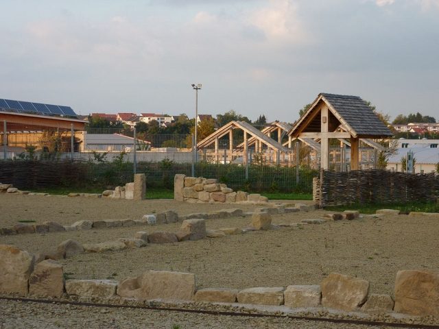
The roman village can be visited
Roman Village Güglingen

The archaeological open-air museum in Güglingen deals with the remains of Güglingen from the Roman period. As early as 1841, the then city pastor Karl Klunzinger had investigated the archaeological monuments near Güglingen based on numerous individual finds. At that time, however, it was still assumed that only a single Roman estate had existed here. From 1999 to 2005, excavations were carried out on an area of approximately 4.5 hectares in what is now an industrial area of Güglingen. It turned out that the place was significantly larger in Roman times than in later phases. During the excavation, more than 30 houses, a public bath, and two Mithraea were investigated.
The Vicus, whose Latin name is unknown, is likely to have comprised a total of about 80 houses on an area of ten hectares. It was located at a crossroads of the Zabertalstraße with a road that led into the town from Walheim. Presumably, the place, which was settled by Romans from about 120 to 250 AD, formed only an economic, but not a military center. Mainly craftsmen and traders are likely to have lived in its strip houses. The settlement was apparently systematically cleared in the middle of the 3rd century, and many buildings were set on fire at that time. After this withdrawal of the Romans, Alamanni settled in the area in the 270s, living there for about two generations.
Site+
A large part of the ancient buildings is now built over or at least not excavated. The open-air site is located in the immediate vicinity of the municipal building yard, industrial companies, and roads and can therefore only present two road or path courses that correspond to the ancient traffic routes in Güglingen. In addition, there are the above-ground indicated floor plans of two houses including their gardens or courtyards and enclosures. One of these houses had an eight-meter-deep well, which was restored. Next to it is a period-typical wattle fence.
At the edge of the former town and in the center of today's open-air site is one of two Mithraea that were found here in a small area. Mithraeum I, excavated in 1999, is now covered by earth again. This Mithraeum was the older such sanctuary on site. The massive stone building was erected in the second half of the 2nd century and later modified. It existed until the 3rd century. Its cult room was about 65 square meters.
From 2002 to 2004, the somewhat smaller Mithraeum II, a timber-framed building, was excavated. Here, three construction phases could be identified, of which the third is now partially reconstructed with timber framing. In this third form, the building, which was originally erected around the middle of the 2nd century, existed from about the beginning to the middle of the 3rd century. As with many other buildings of the Vicus, targeted arson is to be assumed for the destruction of the building. However, the furnishings of the cult room remained largely preserved. Interesting, for example, is the ceiling painting, which unusually shows geometric ornamentation instead of a starry sky. Inside the Mithraeum, numerous votive stones and cult objects were found, including drinking vessels, a cult sword, and an iron radiate crown. These original finds are located in a scale reconstruction of the Mithraeum in the Roman Museum in Güglingen. The reconstruction presented in the open-air site shows the division into an antechamber and cult room as well as the layout of the actual cult room with bricked and oak-slatted podiums on the long sides. The plastered mortar joints of these podiums show the ancient red decorative line. Several information boards on the open-air site provide information about the Mithras cult.
The site is overgrown with plants that have already been proven for the ancient settlement by paleobotanical investigations. It is freely accessible at all times but cannot be described as barrier-free.
Take Mobile History with you
You are reading this text for free. Premium adds what matters on the road: descriptions read aloud, sites found through your camera, whole regions taken offline.
- Every description, including the ~17,700 Premium sites
- Audio guide: have descriptions read to you on location
- AR finder: see sites through your camera, with distance and bearing
- Unlimited saved sites
14 days free, then from €2.99 a month. Cancel anytime.
Source: Wikipedia · Licence: CC BY-SA 4.0 · Image: https://commons.wikimedia.org/wiki/File:G%C3%BCglingen_H%C3%A4userreste.jpg
This description draws on the facts documented in the linked Wikipedia article; Wikipedia content is licensed under CC BY-SA 4.0. Wording and editing: Mobile History.
Location: 49.0617, 9.0046