The roman town can be visited
Ancient BuildingSilchester
Roman City Calleva Atrebatum
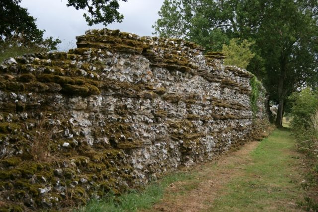
The remains of Calleva Atrebatum, a Roman city, are located near the modern village of Silchester in Hampshire, England. The archaeological site is valuable as it was never re-settled after the Roman period, thus offering a window into Roman urban planning and daily life.
History+
Settlement at the site dates back to the Neolithic period, but a permanent settlement was established only in the 4th century BC. Calleva Atrebatum became the main center of the Celtic Atrebates tribe, whose king Eppillus minted his own coins here. After the Roman conquest of Britain in 43 AD, the Celtic city continued to flourish but was likely destroyed during the Boudicca revolt. Subsequently, the city was rebuilt and received a completely new, rectilinear street grid around 100 AD. At the center of the Roman city was a forum with a basilica, the first phase of which began around 85 AD. From the mid-3rd century AD, the basilica was used for blacksmithing, indicating a change in function. The city also featured a large inn (mansio), baths, and several Gallo-Roman temples. The ruins were never built over, and the city wall is still visible in places today, giving rise to early legends about the site. Systematic excavations began in 1890 and continue to this day, making Calleva Atrebatum one of the most thoroughly researched Roman cities in England.
Location+
The ancient city of Calleva Atrebatum is situated at an elevation of approximately 98 meters above sea level in Silchester, a village in the county of Hampshire in the United Kingdom.
On site+
The Roman city of Calleva Atrebatum is now accessible as an archaeological site and can be visited. Visitors can explore the excavated foundations and partially preserved city walls.
Take Mobile History with you
You are reading this text for free. Premium adds what matters on the road: descriptions read aloud, sites found through your camera, whole regions taken offline.
- Every description, including the ~17,700 Premium sites
- Audio guide: have descriptions read to you on location
- AR finder: see sites through your camera, with distance and bearing
- Unlimited saved sites
14 days free, then from €2.99 a month. Cancel anytime.
Source: Wikipedia · Licence: CC BY-SA 4.0
This description draws on the facts documented in the linked Wikipedia article; Wikipedia content is licensed under CC BY-SA 4.0. Wording and editing: Mobile History.
Location: 51.3575, -1.0828