The villa can be visit.
Roman Villa Rustica (Roderath)

The reconstruction of the Roman farmstead at the entrance to Roderath has made significant progress. What was previously difficult to imagine has now taken shape through freshly planted hedges and newly laid paths, combined with existing wall sections. The farm complex, situated on a slope, presents itself impressively. Equally impressive is the public-private partnership, previously unknown in this diverse form, which made the implementation possible.
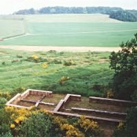
Between 1984 and 1989, a Roman estate, a so-called villa rustica, was excavated west of the village of Roderath. In addition to a main house with a stone plinth, several outbuildings in timber construction, as well as minor remains of an oven and a water pipe, were discovered. The municipality of Nettersheim and the population of Roderath always wished to make the results of this excavation visible on site. Besides the interest of the village community in keeping its own history alive, visitors and guests should also gain an impression of the Roman past of the place.
With the reconstruction of the foundation walls of the main building, a first step in this direction was taken immediately after the excavation. In the following period, various plans were made, including further reconstruction measures in solid construction, but these could not be implemented, partly due to financial reasons. With the confidence that the site would nevertheless be made visible, signage was already put in place, funded by the district of Euskirchen. In 2004, in close cooperation with the Rhenish Office for Archaeological Heritage, Nideggen-Wollersheim branch, a reconstruction concept was developed that was both professionally sound and cost-effective. The then head of the branch, Paul Wagner, created a design draft that served as the basis for the implementation: beech hedges make the size and position of the outbuildings visible, and the courtyard area is also enclosed by beech hedges.
Take Mobile History with you
You are reading this text for free. Premium adds what matters on the road: descriptions read aloud, sites found through your camera, whole regions taken offline.
- Every description, including the ~17,700 Premium sites
- Audio guide: have descriptions read to you on location
- AR finder: see sites through your camera, with distance and bearing
- Unlimited saved sites
14 days free, then from €2.99 a month. Cancel anytime.
Source: Wikipedia · Licence: CC BY-SA 4.0
This description draws on the facts documented in the linked Wikipedia article; Wikipedia content is licensed under CC BY-SA 4.0. Wording and editing: Mobile History.
Location: 50.5063, 6.7022