Ancient BuildingRossatz-Arnsdorf-Bacharnsdorf

Roman Castle Bacharnsdorf
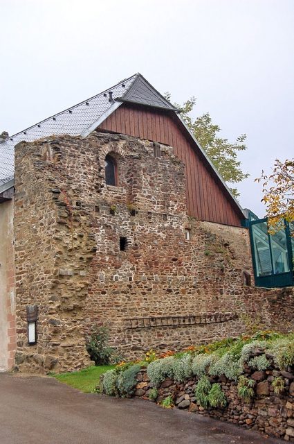
Roman Castle Bacharnsdorf

The remains of the roman Castle can be visited

The Burgus of Bacharnsdorf was part of the chain of fortifications of the Roman Danube Limes in Austria, federal state Lower Austria, district Krems-Land, municipality Rossatz-Arnsdorf.

The Valentinian defensive structure is one of the best-preserved Roman monuments in the Roman province of Noricum. In addition to the Burgus, this article also covers the watchtowers of Sankt Lorenz and Rossatz-Windstallgraben.

Location and Research History+

The district of Bacharnsdorf is located at the northeastern end of a river plain near the village of Mitterarnsdorf, shortly before the Danube flows through a narrow section here, about 13 km upstream from Mautern an der Donau, on federal highway 33. The name of the place goes back to Bishop Arno of Salzburg, to whom Emperor Charlemagne granted a fief here in the 8th century.

The ruin itself is embedded in the grown townscape near the house Bacharnsdorf No. 7. Its remains directly border a medieval farm building to the south, slightly higher terrain to the west, and a garden area to the north. An information board has been placed on the east wall.

Already in the 19th century, a former Roman watchtower was suspected here due to the existing building fabric and coin finds. Friedrich von Kenner, Eduard von Sacken, and Eduard Nowotny also expressed the assumption that opposite Spitz an der Donau, above the village of Arnsdorf, a Roman observation post must have existed due to the favorable topographical location. However, Gertrud Pascher described this in her compilation of finds from Arnsdorf as "mere conjecture" as usually only reports of coin finds from this area were available. In the summer of 1964, local historian Alois Topitz, among others, again drew attention to the presence of this Burgus. After reporting to the responsible authorities, an initial investigation was carried out in 1970 by the Austrian Archaeological Institute (Herma Stiglitz), and the Roman origin of the masonry was unequivocally confirmed by ceramic finds. In 1985, a building survey was finally carried out by the Austrian Federal Monuments Office (Gertrude Wlach, Marcelo Moreno-Huerta, Hannsjörg Ubl). In the north, west, and especially in the east, the material was removed down to below the ancient foundation layer. This was followed by a complete renovation and conservation of the wall remains. Ancient sources or inscriptions for this tower are not known to date. The discovered ceramics are kept in the Mautern an der Donau Museum.

Findings+

The appearance of this fortification can be well reconstructed from the south wall, which is preserved to a height of over 9 m. The tower had two floors and no basement. The square floor plan measures approximately 12.2 x 12.4 m. The building stands on foundations about 1.5 m wide, the rising masonry is about 1.6 m wide and tapers upwards. In the individual floors, the impressions of the beam heads for the bracing of the intermediate ceilings are clearly visible. The south-west corner is still preserved up to a height of 2 m. The entrance was in the north, presumably on the ground floor, the first floor was ventilated by two slit windows on each side. On the second floor, two large arched windows broke through the walls. The ground floor probably served as a storage room, the first as accommodation for the crew, and the second floor as a guardroom. The Burgus probably had a tent-shaped, tiled roof. Remains of a rampart surrounding the tower could not be observed.

Function and Dating+

The Burgus secured the Danube bank and the access to the Kupfertal (Dürrenbachtal), which opens to the southeast towards the Danube, through which a Roman track road ran, connecting the Wachau with the imperial road between Cetium (St. Pölten) and Namare (Melk). It was probably built around 370 AD by soldiers of the milites auxiliares Lauriacenses as part of Valentinian I's border security measures. The tower was used until the High Middle Ages.

Course of the Limes between Burgus Bacharnsdorf and Castrum Favianis+

Burgus St. Lorenz The church of St. Lorenz is located west of Rossatz, on the right bank of the Danube, directly at the landing stage of the car ferry to Weißenkirchen in der Wachau; it can be reached via federal highway 3 or the Danube Cycle Path. The church is one of the smallest places of worship in the Wachau and was built as a place of devotion for river boatmen. The remains of a late antique Burgus are built into the northern tower-like building. The northern wall of the church nave forms the older south wall of the rectory and thus also that of the Burgus. A section of it can still be seen on the west side between the house roof and the church. Its dating is unknown. Watchtower Rossatz-Windstallgraben This monument is also located in the municipality of Rossatz-Arnsdorf. The tower is located approximately 6 km upstream from Mautern an der Donau on federal highway 33, directly at the confluence of the Oberbergern-Rossatz footpath (formerly Rossitzergraben) on the right bank of the Danube. The remains of the tower are freely accessible.

The Benedictine abbot and amateur archaeologist Adalbert Dungel, during his investigation of Roman remains in the Wachau in 1906, suspected a Roman outpost here in the "Windstallgraben near Rossatzbach", municipality of Oberbergern, in the area with the field name "Zu den sieben Gräbern". However, only individual coin finds were attested. The watchtower was finally discovered in 1952 during the expansion of the B 33, excavated ten years later, and the remains restored and conserved in 1992.

Due to the strength and construction of the foundations, the building probably dates from late antiquity (4th century). The square tower measured about 9 x 9 m, covered an area of about 12.4 m², and was built over an older, smaller predecessor from the 2nd to 3rd century AD. The walls were built using cast masonry technique and measured 1.2 m. The northeast side, running parallel to the B 33, was destroyed except for the foundation walls located in the roadside ditch. The southeast side, devastated by up to 1/3, showed the same picture. On the southwest corner, up to 1.5 m of rising masonry was preserved. The further course of the SW front and also the southern section of the northwest side were completely destroyed. A 1 m high remnant of the southeast corner also remained. A possibly surrounding moated ditch could no longer be determined. Finds (heat-cracked/stamped bricks) suggest that it was also built in the late 4th century AD and later destroyed by fire. It was probably also covered by a tiled roof in the upper part. Small finds (fibula, bracelet) confirm that the tower was still occupied in the 5th century. Wall remains on the east side suggest continued use from the High Middle Ages to the early modern period.

Adalbert Dungel and Franz Kainz were of the opinion that the tower was primarily intended to prevent circumvention of Castrum Favianis (Mautern an der Donau). Furthermore, the Limes road connecting Mautern with Melk (Namare) ran in a forest hollow behind the tower and could also be secured in this way. In addition, the right bank of the Danube in the section "von den Kugeln" (below the Ferdinandswarte) to the mouth of the Windstallgraben into the Danube had no land connection until the 19th century. Only at Bacharnsdorf did a path from Schenkenbrunn in the Dunkelsteiner Wald through the Kupfertal along the Dürrenbach lead back to the Danube. In summary, the tower crew thus not only controlled the Danube border but also blocked the valley cut open to the south over the Dunkelsteiner Wald into the hinterland.

Take Mobile History with you

You are reading this text for free. Premium adds what matters on the road: descriptions read aloud, sites found through your camera, whole regions taken offline.

  • Every description, including the ~17,700 Premium sites
  • Audio guide: have descriptions read to you on location
  • AR finder: see sites through your camera, with distance and bearing
  • Unlimited saved sites

14 days free, then from €2.99 a month. Cancel anytime.

Source: Wikipedia · Licence: CC BY-SA 4.0 · Image: http://commons.wikimedia.org/wiki/File:Bacharnsdorf_Burgus1.JPG

This description draws on the facts documented in the linked Wikipedia article; Wikipedia content is licensed under CC BY-SA 4.0. Wording and editing: Mobile History.

Location: 48.3694, 15.4449