Ancient BuildingPommern

Roman Temple Martberg
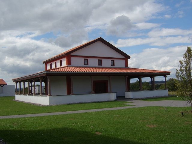
Roman Temple Martberg

The Roman Temple can be visited

The Martberg is a mountain between Pommern and Karden on the Lower Moselle, where in pre-Roman times there was an oppidum of the Treveri and in Roman times an extensive temple district where the god Mars Lenus was worshipped. The name can be traced back to the worship of this deity.

The Martberg is located approximately 40 km upstream from the mouth of the Moselle in Koblenz. It is a table mountain, whose highest point is at 273.2 m above sea level and thus approximately 190 m above the Moselle. Together with the neighboring Hüttenberg, it forms a mountain plateau with a total area of more than 70 ha, which drops into very deeply incised valleys on three sides. To the south, the plateau is bordered by the Moselle, to the northwest by the Pommerbach valley, and to the northeast by the Brohlbach valley. It is only accessible from the north via a narrow ridge.

Research History+

Since ancient times, the Martberg has been known as a rich site of Roman antiquities. The first systematic research was carried out between 1885 and 1890 by the Rheinisches Landesmuseum Bonn under the direction of Joseph Klein. Even then, a large enclosed temple district with numerous temples and ancillary buildings could be identified. In 1987, the State Office for Monument Preservation Rhineland-Palatinate in Koblenz investigated the ramparts of the Martberg through several excavation trenches. Since 1994, the systematic archaeological exploration of the Martberg has been ongoing under the direction of the State Office for Monument Preservation Koblenz and with the support of the German Research Foundation.

Settlement History+

The first traces of settlement on the Mart- and Hüttenberg can be traced back to the Neolithic period. This is evident from some excavated settlement pits and surface finds. More intensive settlement can be proven for the Early La Tène period. In the Late La Tène period, settlement activity on the Mart- and Hüttenberg reached its peak. The settlement reached its greatest extent in the 1st century BC. Recent research, through excavations and geomagnetic surveys, has shown an almost complete settlement of the Martberg plateau (approx. 50 ha) and a partial settlement of the Hüttenberg. The settlement pattern was characterized by farm groups consisting of a mostly square dwelling house with a floor area of approx. 25 to 50 m² and smaller storage houses (approx. 4 to 15 m²). Numerous metal slags and furnace remains, representing the remnants of metal workshops, were found within the settlement. Far-reaching trade relations can be seen in the import of Roman wine amphorae. The proof of the Martberg as a minting site was provided by the finds of blanks and coin molds, underlining its function as a superordinate central place. During the period of its greatest expansion, the city was fortified by a 3.2 km long Pfostenschlitzmauer (post-slot wall), which was renewed at least three times. In the course of Romanization, the settlement on the Martberg was abandoned in the 1st century AD in favor of the Vicus Cardena, the present-day Treis-Karden, which emerged on the Moselle. However, the sacred district in the center of the mountain remained and flourished in the following centuries.

Sanctuary+

At the highest point of the mountain, there was already a sacred district during the time of the Celtic city, which was rebuilt and expanded in several phases during the Roman era. The oldest evidence for religious practices dates to the middle of the 1st century BC. At this time, a rectangular ditch measuring 10 x 12 m was excavated in the area of Temple K (see fig.), in which numerous sacrificial objects were deposited. In the early Roman Imperial period, the central cult district was replaced by a representative timber-framed temple and supplemented by further temples and a rectangular enclosure. In the 3rd century AD, the expansion of the temple district reached its peak. Now, in the center, there was a mighty stone ambulatory temple in Gallo-Roman style, surrounded by three smaller temples. The district was delimited externally by a large 60 x 70 m portico. In the course of Christianization, the temple district was abandoned around 400 AD. The town of Cardena, located below the Martberg, now developed into the religious center of the new religion.

Countless offerings found during the excavations bear witness to the religious acts performed on the Martberg. In the Late La Tène period, these were mainly coins, fibulae, and weapons, which were sacrificed and sometimes ritually destroyed before being deposited. In Roman times, the Celtic custom of sacrificing coins and jewelry continued, as evidenced by thousands of coins, hundreds of fibulae, and pieces of jewelry. New was the offering of countless miniature clay vessels. Of particular importance are two inscribed stones that attest to the worship of the Treverian healing god Lenus-Mars in the sanctuary. One of these inscriptions is written in Latin and Greek and was donated by a Greek named Tychicos, who thanks Lenus-Mars for his healing. Another special feature of the finds on the Martberg is its enormous wealth of coins. Over 10,000 coins are in museum collections, countless others have been lost over the centuries. About 2000 of them are Celtic mintings, making the Martberg one of the most important sites for the study of Celtic coinage.

Reconstructions+

In 2004, the temple district was partially rebuilt and, together with other reconstructions of the Celtic settlement, is accessible to visitors in the Martberg Archaeological Park. Many archaeological finds from the research on the Martberg can be viewed in the Stiftsmuseum Treis-Karden and the Landesmuseum Koblenz.

Take Mobile History with you

You are reading this text for free. Premium adds what matters on the road: descriptions read aloud, sites found through your camera, whole regions taken offline.

  • Every description, including the ~17,700 Premium sites
  • Audio guide: have descriptions read to you on location
  • AR finder: see sites through your camera, with distance and bearing
  • Unlimited saved sites

14 days free, then from €2.99 a month. Cancel anytime.

Source: Wikipedia · Licence: CC BY-SA 4.0 · Image: http://de.wikipedia.org/wiki/Datei:Martbergtempel.jpg

This description draws on the facts documented in the linked Wikipedia article; Wikipedia content is licensed under CC BY-SA 4.0. Wording and editing: Mobile History.

Location: 50.1786, 7.2864