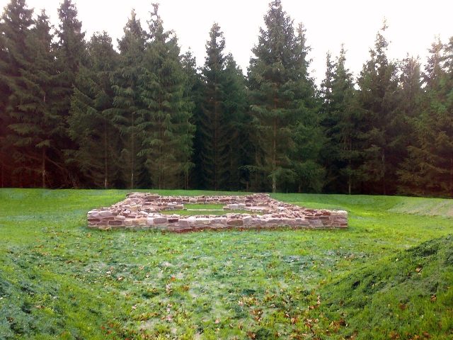
The remains of the roman Castle can be visited
Roman Castle Altes Jagdhaus

The small fort Altes Jagdhaus is a Roman fort on the western Taunus stretch (Section 3) of the Upper Germanic Limes, which gained UNESCO World Heritage status in 2005. The archaeological monument, still very visible above ground, is located southeast of Arnoldshain-Hegewiese, a district of the municipality of Schmitten in the Hessian Hochtaunuskreis. The current name derives from a hunting lodge built within the fort in the 16th century.
The small fort is located in the densely forested areas of the Hochtaunus ridge, almost three kilometers as the crow flies northwest of the Großer Feldberg and a good kilometer southeast of Hegewiese, a residential area of the Schmitten district of Arnoldshain, situated separately in the forest. It lies at an altitude of 678 meters, a good 300 m east of a pass (the Sandplacken), where the state road 3004, leading from Oberursel to Schmitten, crosses the Taunus ridge between the "Mittelberg" (715 m above sea level) of the Feldberg massif and the Kolbenberg (683.9 m above sea level), and where the so-called "Hochtaunusstraße" – state road 3024 – and the "Siegfriedstraße" – state road 3276 – meet state road 3004.
The small fort, which had already been documented by Carl Rossel and Karl August von Cohausen, was archaeologically excavated in the summer of 1893 by Louis Jacobi, the responsible section commissioner of the Imperial Limes Commission (RLK).
In 2009, the entire ensemble was conserved.
Findings+
The small fort Altes Jagdhaus was a stone fort with a slightly trapezoidal ground plan. The defensive wall had rounded corners; its thickness was 1.7 m on the north side, and 2.2 m to 2.3 m on all other sides. It was constructed as dry masonry from only roughly worked quartzite rubble stones. A ditch does not seem to have been present. With its single gate, the fort was oriented northwards, towards the Limes. The gate consisted of a simple wall passage – without recessed cheeks or superstructures – 3.3 m wide, which was shifted about one meter east of the camp's central axis. The fort, whose front was not parallel but oblique to the Limes, was 9 m from the crest of the border wall at its northwest corner and 14 m at its northeast corner.
The interior of the Roman fortification was disturbed by the foundations of a modern building measuring 7 m in width and 10.7 m in length. The walls of the structure were entirely built of mortared brick, and the floor of the main room was also laid with quartzite slabs. This 16th-century building was probably a hunting lodge of the "Waldbote" (forest messenger) of the Hessian princes.
Nothing is known about the garrison of the small fort, presumably a vexillatio of a neighboring larger auxiliary unit or legion. It may have been subordinate to Saalburg fort. The fortification was probably built only around the middle of the second century AD.
Altes Jagdhaus+
Probably in the 16th century, a hunting lodge of the Hohe Mark common land association was built within the remains of the small fort. It was primarily used by the Waldbote, an office inherited by the Landgraves of Hessen-Homburg. This office secured several privileges, such as presiding over the assembly of the Hohe Mark or the right to start hunting three days earlier than other commoners. The main room of the hunting lodge originally had a stone slab pavement. It had a fireplace and built-in seating in the corners. A storage cellar was built into the ground under the adjoining room.
In 2009, the complex was renovated at a cost of 60,000 €. The remains of the Roman ramparts were preserved by earth embankments. The foundations of the hunting lodge were reinforced with a concrete foundation and secured with mortar. This makes the building's floor plan recognizable to visitors.
Course of the Limes between the small forts Altes Jagdhaus and Heidenstock+
From the small fort Altes Jagdhaus to the small fort Heidenstock, the Limes runs exclusively through the densely forested area of the Taunus ridge. In doing so, it drops by almost 70 meters in altitude overall. Due to the geological-topographical conditions, it has the peculiarity in this area that in some sections, instead of the ditch, which could only be excavated with difficulty in the existing quartzite rock and whose excavated material was usually used to build the rampart, a stone wall was erected. This wall had an average thickness of two and a half meters and was constructed as dry masonry with quartzite rubble stones. The palisade ditch, however, was continuously present even in these sections of the Limes.
Traces of the Limes structures between the small fort Altes Jagdhaus and the small fort Heidenstock. KK Kleinkastell Altes Jagdhaus see above Wp 3/54 Suspected, but not archaeologically proven, tower site. Wp 3/55 "Klingenkopf" Tower site of a wooden and a stone tower, already documented by Rossel and Cohausen, which were investigated by the commission under Jacobi in 1894.
The wooden tower was circularly surrounded by a 1.2 m deep, 12 m diameter ditch and an eight-meter-wide rampart. In the center of the complex, four large post holes, 1.2 m deep into the bedrock, formed a slightly irregular quadrangle with sides measuring 4.5 m to 5.0 m. The Limes wall cut through the northern half of the wooden tower site, while the palisade curved widely around the tower.
The stone tower was located about 22 m southeast of the wooden tower. It had a square ground plan with sides measuring 5.6 m. On the east side, the rising masonry had a thickness of 90 cm to 95 cm up to a height of about 1.4 m. It then receded on both the outer and inner sides, thereby tapering to a thickness of 65 cm to 75 cm. On all other sides of the tower, however, the wall did not taper up to a maximum recorded remaining height of two meters. In places, the white plaster, painted with red false joints, could still be detected on the outside of the tower. On the north side, 25 cm above the rammed floor of the interior, there was a 75 cm wide entrance. The distance of the tower to the Limes wall was 21 m, and it was 32 m away from the palisade ditch.
The location of the tower site was optimally chosen. The view extended from there into the "Stannheimer Grund" and the upper "Erlenbachtal".
Wp 3/56 Suspected, but not archaeologically proven, tower site. KK Kleinkastell Heidenstock see main article Kleinkastell Heidenstock
Take Mobile History with you
You are reading this text for free. Premium adds what matters on the road: descriptions read aloud, sites found through your camera, whole regions taken offline.
- Every description, including the ~17,700 Premium sites
- Audio guide: have descriptions read to you on location
- AR finder: see sites through your camera, with distance and bearing
- Unlimited saved sites
14 days free, then from €2.99 a month. Cancel anytime.
Source: Wikipedia · Licence: CC BY-SA 4.0 · Image: http://commons.wikimedia.org/wiki/File:Altes_Jagdhaus_1.jpg
This description draws on the facts documented in the linked Wikipedia article; Wikipedia content is licensed under CC BY-SA 4.0. Wording and editing: Mobile History.
Location: 50.2446, 8.4929