The remains of the Castle can be visited
Roman Fort Anderitum (Pevensey Castle)
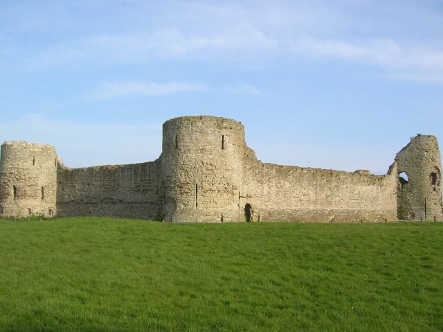
Anderitum (also Anderida, Anderidos) is a Saxon Shore Fort in the Roman province of Britannia. It is located at in eastern Pevensey in the English county of East Sussex and was later converted into a medieval castle known as Pevensey Castle.
Roman fort+
It was built by the Romans during a time when Britain was still part of the Roman Empire. Recent dendrochronological dating of wooden foundation piles have dated this to AD 290. It used to be customary to state that at this time the south and east of the province Britannia were under constant attack from marauding barbarian Jutes and Saxons, but more recent thinking focuses on the internal disputes of the Roman Empire in that period. The south and eastern seaboards of Britannia were collectively known as 'the Saxon Shore' and several large forts were built along them.
The fort was built on what was then peninsula of land rising above the coastal marshes. The sea washed over what is now Pevensey Marshes surrounding Anderida on three sides, so giving a safe and sheltered landing point. This marshy inlet of the sea, extending inland as far as Hailsham, was studded with small areas of high land which remained as islands at high tide so giving the place-names of Rickney, Horse Eye, North Eye and Pevensey. All are derived from the Old English word īeg, meaning island.
The Roman road leading west away from the fort was built much earlier than the fort itself. There was probably a port already in existence in the area when the fort was built, though this has yet to be found.
The fort was repaired, possibly on the instructions of the great Roman General Stilicho, about AD 400. The massive Roman enceinte still stands but little damaged.
Saxon fort+
The sub-Roman Brythons apparently occupied the fort in 491, though whether this was part of a long term residency or a temporary one necessitated by Saxon raids is unclear. The Anglo-Saxon Chronicle records that they were massacred there, at Andredesceaster, by King Ælle of Sussex and his son Cissa in that year, leaving none alive.
Evidence for some form of permanent occupancy next appears in 1042, when the Anglo-Saxon Earl of Wessex, Harold Godwinson (later King Harold II) established a strong point there, improving fortifications by digging ditches within the walls of the Roman fort. The English army remained at the fort during the summer of 1066 before abandoning it to invade further south. When the Duke William the Conqueror of Normandy invaded Sussex, landing at Pevensey Bay in September 1066, there were no defences at Pevensey or anywhere else on the south coast. Upon landing, the invading Normans created a dry ditch around the west gate. This is because they did not have time before the battle to modernise the castle. The ditch would make it harder to get in to the castle if William was attacked whilst inside. In 1066 at the ensuing Battle of Hastings on Senlac Hill, Duke William defeated the combined English armies led by King Harold II.
Medieval castle+
Robert, Count of Mortain (half-brother to William the Conqueror) was granted Pevensey shortly after the Norman Conquest. Mortain used the existing fort as the basis for building a castle around 1100, carrying out only minor repairs to the walls to form an outer bailey, and building a new wooden palisaded irregular rectangular-shaped inner bailey against the Roman wall. Shortly afterwards, a rectangular stone keep was erected, incorporating part of the east curtain wall and a Roman bastion. The original main entrance to the south-west and the east gateway were both repaired.
The castle was besieged by William Rufus in the Rebellion of 1088 and during a period of civil war by the forces loyal to King Stephen (1135–1141). Around 1190-1220 the present twin-towered gateway was constructed, making it one of the earliest known examples of this type. A stone circuit wall was erected around the inner bailey by Peter of Savoy around 1250, with three D-shaped towers. A third siege occurred in 1264, when Henry III's supporters took refuge at the castle following the Battle of Lewes and were besieged by Simon de Montfort.
The castle remained in use throughout the Late Middle Ages. In 1415, king Henry V sent his hostage king James I of Scotland to the castle.
Post medieval times+
During later times the ancient castle nearly did not survive. Queen Elizabeth I ordered the castle to be demolished but this was ignored. In fact the castle boasts Elizabethan 'gun emplacements', earthworks and an Elizabethan cannon mounted on a replica carriage. During the period of interregnum under Oliver Cromwell efforts were again made to destroy it but luckily only a few stones were removed.
Second World War+
During the World War II the castle was used by the home guard and as a military camp for anti-aircraft troops. It also housed American and Canadian troops who were officially responsible for this section of coast in case of an invasion. As late as 1942 small additions were made to fortify the castle in case of German invasion across the Channel. This was far from fanciful as post-war exposure of German plans in Operation Sea Lion showed that this would have been the route of the invasion from the beaches to seize London.
A number of pillbox defences were built into the fabric of the castle. As shown in the picture on the left these were cunningly disguised by using local stone on the front and even today are hard to distinguish without the benefit of a guidebook. Unlike the picture, many are built low into the walls so have no distinguishing feature except the gun slits. A conscious decision was made to leave these pillboxes in place after the war as they portray the unique direct role Pevensey has played in the defence of Britain from Roman times to the 20th century.
Take Mobile History with you
You are reading this text for free. Premium adds what matters on the road: descriptions read aloud, sites found through your camera, whole regions taken offline.
- Every description, including the ~17,700 Premium sites
- Audio guide: have descriptions read to you on location
- AR finder: see sites through your camera, with distance and bearing
- Unlimited saved sites
14 days free, then from €2.99 a month. Cancel anytime.
Source: Wikipedia · Licence: CC BY-SA 4.0
This description draws on the facts documented in the linked Wikipedia article; Wikipedia content is licensed under CC BY-SA 4.0. Wording and editing: Mobile History.
Location: 50.8192, 0.3341