Ancient BuildingLich

Roman Castle Arnsburg (Lich)
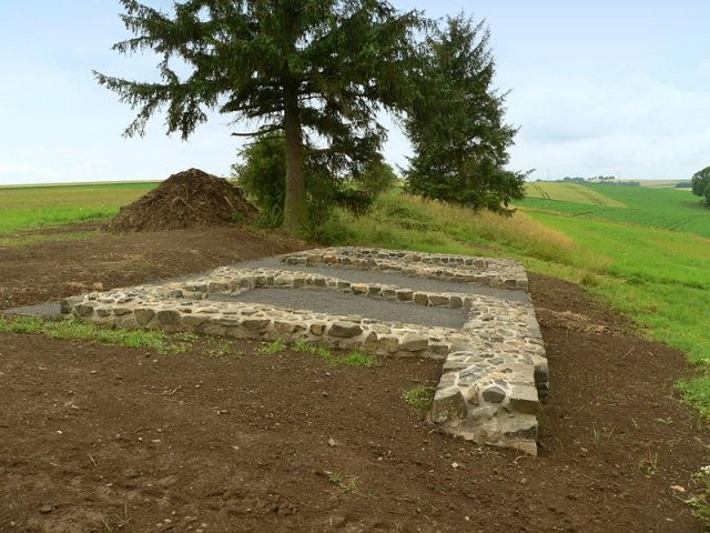
Roman Castle Arnsburg (Lich)

The Roman Castle can be visited

Arnsburg Fort, also known as Arnsburg-Alteburg Fort when including the terrain name, existed as a Roman cohort fort in the northernmost Limes bend west of the city of Lich in the Wetterau region of Hesse from before 90 to 260 AD. It was built under Emperor Domitian and, during its function as an exposed military outpost, was occupied by various cohorts.

Almost 1000 years after the Romans abandoned the fort, Benedictine monks attempted to establish a monastery on the site. However, construction work on the monastery church, begun with materials from the abandoned fort, was halted after only 22 years, and the Benedictines were replaced by Cistercians, whose buildings were erected less than 1000 meters from the fort on the grounds of what is now Arnsburg Monastery.

As the northernmost cohort fort on the Limes, the archaeological monument, with its few visible, reconstructed foundation walls, lies on a plateau 15 meters above the confluence of the Welsbach into the Wetter river, at the intersection of several Roman roads. The strategically favorable location of the fort is evident in the arrangement of the watchtowers on the ramparts, from which the Limes frontier wall, running approximately 1.5 kilometers northeast of here, could be viewed unobstructed over a long distance.

From the B 488 towards Lich, a few kilometers after exit 39 of the A 45, the road branches off towards Muschenheim. After about 500 meters, the road crosses the Welsbach. Behind the bridge, there is a small parking lot on the roadside, from which a footpath leads up to the fort plateau. The small cemetery, which is reached first, belongs to Hof Güll and is already on the grounds of the former fort. To the right of the cemetery gate are the visible excavations of the north gate of Arnsburg Fort.

On July 15, 2005, the Upper Germanic-Raetian Limes was added to the UNESCO World Heritage List. The work for the application included reviewing the aerial photograph archive at the State Office for Monument Preservation in Wiesbaden to document the Limes sections in Hesse as completely as possible.

In addition to known earlier findings by Solms-Laubach rent official Fabricius, who in 1842 already noticed differences in vegetation and color in the then clover field, measured them, and thus proved the existence and exact location of the cohort fort on the Alteburg, which originated before 90 AD, several new findings were discovered and registered on photographs taken by Otto Braasch around the fort in the summers of 1986 and 1990. Northwest of the fort, the outlines of two large, unconnected Roman camps were recognized, one of them with a ground area of 5.6 hectares, almost twice as large as the later fort of 2.9 hectares. However, traces of gates or other internal structures were not visible in these images.

Subsequently, a geophysical survey was carried out over a total area of ten thousand square meters to learn more about the extent of the camps. This succeeded in locating the northern ditch and two camp corners of the larger camp, making it possible to create a hypothetical camp plan. Even this investigation could not prove any internal buildings.

Although the historical classification remains problematic in such a finding due to a lack of chronological criteria, it is assumed that the two camps were chronologically successive and were built only for short-term occupation with tents. The size of the second camp suggests an occupation of up to 1000 soldiers, who were probably involved in military operations in the Wetterau during the Germanic Wars under Emperors Augustus and Tiberius between 12 BC and 16 AD. However, the intensity and spatial extent of the hostilities remain unclear.

Archaeological research in the area of the fortified fort brought to light artifacts that also indicate a military camp from the time of the Germanic Wars, so the fort site must also be considered as a pre-Limes camp site, i.e., existing before the year 90.

The renewed viewing of the aerial photographs also provided evidence of a bathhouse on the grounds of the extensive camp village (vicus), built as accommodation for the soldiers' family members, on the Roman long-distance road leading south directly in front of the fort's south gate. The recognizable contours clearly indicated the outlines of a Roman fort bath. Similar structures within the foundations of a manor house located east of the ramparts had already been localized on photographs, so there must have been two bathhouses in the area of Arnsburg Fort, but not necessarily at the same time. Proof that the building on the road was a bath was provided by the discovery of an 875-gram brick fragment, the surface of which was covered with calcareous sinter due to constant contact with water. Slightly further from the south gate, still within the camp village, there was an amphitheater.

The Imperial Limes Commission (RLK) conducted archaeological investigations on the north side of the fort in 1893 and unearthed the foundations of both towers of the north gate, which were partially rebuilt and thus made visible a few years later, probably by the Upper Hessian Historical Society in Giessen. Over the next 100 years, drifting sand increasingly covered the excavations. At the end of 2006, the buried foundations of the gate were restored again, and the western corner of the enclosure was rebuilt close to the ground. The reconstructions were erected on concrete slabs sunk into the earth so as not to mislead researchers of subsequent generations into believing that the masonry was Roman originals.

In the summer of 2008, the fort area was again archaeologically investigated on behalf of the Archaeological Society in Hesse with the aim of gaining a more precise picture of the overall complex, which was only insignificantly built over. Non-destructive prospecting methods were used to investigate the entire fort area, the fort bath, the vicus, the amphitheater, and a cemetery, using a combination of various geophysical methods such as geomagnetics, geoelectrics, and ground-penetrating radar. The measure was related to the already implemented decommissioning of the total area of 7 hectares. In addition to the fort, the camp village was also investigated. A large part of the internal structure could be documented. A ditch was also discovered that completely enclosed the vicus located south of the fort. The finding of a fortified camp village is rare on the Limes so far, although similar observations could be made at the nearby Ober-Florstadt Fort.

Fort+

Initially built as a wood-and-earth camp in the second half of the 1st century, Arnsburg-Alteburg Fort was already secured by enclosing walls at the beginning of the 2nd century, following the Roman rectangular scheme with four gates, each secured by two towers. The main gate, designed as a double gate with two additional towers, was located on the eastward-facing narrow side. In addition, the complex was protected by 14 further towers on the ramparts.

The area, with side lengths of approximately 185 and 160 meters and a circumference of 699 meters, was only slightly smaller than Saalburg with 737 meters and Butzbach Fort with 732 meters. This area provided space for a Roman cohort, i.e., for a troop of about 600 men, and all necessary internal stone buildings such as the headquarters (Principia), the commander's residence (Praetorium), and the granary (Horreum). Near the main gate, remains of a large building were found, probably a manor house or an inn (Mansio).

In the Principia, the remains of an armor clasp were found; garment fragments were found in the fort area. All these remains belonged to one or two large bronzes dating to the first half of the 3rd century.

Fort and Limes

The history of Arnsburg-Alteburg Fort begins in the second half of the 1st century during the time of the Roman Emperor Domitian, a period when the Chatti advanced southward from northern Hesse and established a strong position against the Rhine frontier of the Roman Empire. Domitian, still intent on expanding the Roman Empire, then launched a campaign against the Chatti in 83 AD with great military effort, with the result that, although they were not overcome, they could be pushed back. The now unprotected Wetterau again offered the Romans the opportunity to advance far north and northeast from their base in Mainz, thus keeping the Chatti out of their area. For this purpose, they used a multitude of simple military camps along the newly created frontier line, including at the confluence of the Welsbach with the Wetter river, which gave the landscape its name. In the following more peaceful decades, numerous manor houses were built in the fertile Wetterau to also use the area agriculturally. The military camp on the Wetter was initially greatly enlarged and finally moved to a neighboring high plateau called Alteburg and provided with ramparts.

In the course of the final border demarcation carried out around the year 90, the Romans fortified the military camps located at strategically favorable places and expanded them into forts, according to the requirements of the Limes, including the Alteburg camp. The Limes, whose course in the Wetterau is still well discernible over longer stretches, projected wedge-shaped to the north from the Taunus, via Saalburg and Butzbach to Grüningen, where it reached its northernmost point right of the Rhine. From here, it ran southeast past Alteburg Fort to Inheiden Fort and further to the Main to Großkrotzenburg Fort.

The Limes was subject to constant expansion. Near Alteburg Fort, there were extensions of the ditches and reinforcements of the ramparts over longer stretches even in the 3rd century. In the years 250 to 260, the Romans abandoned the Limes and its associated facilities (Limesfall). Alteburg Fort was abandoned and left to slow decay. The area disappeared from historical view during the Migration Period and reappeared only in 1151, but then under the name Arnsburg.

Subsequent Use

After the abandonment of the Limes, Franks settled the Wetterau. The Roman fiscal land was systematically recorded, and numerous new settlements emerged along the old Roman roads by 800. This resulted in a concentration of royal property in the former Limes area.

In the immediate vicinity of the abandoned Alteburg Fort, two castles were built successively: a smaller one northeast of the fort, dated to around 800, and a second one, 600 meters southeast of the fort remains on the Hainfeld, whose origin is estimated to be around 1000. The latter was abandoned in favor of Münzenberg Castle, and the castle and the surrounding land, including the fort ruins, were handed over to the Benedictine order for a monastery foundation, which they undertook on the fort grounds but abandoned as early as 1174. In the same year, Kuno I von Münzenberg transferred Arnsburg Castle, the fort with the commenced monastery church, and all lands in the Wetter valley to Eberbach Monastery, which sent monks who immediately began the new construction of a monastery church, this time, however, in the Wetter valley bottom, below Arnsburg Castle. Arnsburg Monastery was built here.

All users of the site following the Romans used the Roman fort as a quarry. In 1904, the Butzbach-Licher railway – now abandoned – was laid at the edge of the fort area. The route largely bypassed the central findings.

Troop+

The fort's garrison consisted of partially mounted units. The first known troop in Arnsburg was the Cohors II Aquitanorum equitata (2nd partially mounted cohort of Aquitanians), originating from Aquitaine. The oldest proof of its existence is secured by two military diplomas, which attest to its presence in the province of Germania superior (Upper Germany), to which Arnsburg belonged, on September 19, 82, and October 27, 90. Between 107 and 116, the unit was transferred to the province of Raetia (Raetia) and quartered in the Regensburg fort of Kumpfmühl until the Marcomannic Wars (166–180). It was followed in Arnsburg at the beginning of the 2nd century by the Cohors I Aquitanorum veterana equitata (1st partially mounted veteran cohort of Aquitanians). When this veteran cohort was transferred to Stockstadt Fort after the middle of the 2nd century, the Cohors V Dalmatarum (5th cohort of Dalmatians), also known from Heilbronn-Böckingen Fort, took its place in Arnsburg. A soldier of the 5th Dalmatian cohort stated his hometown as Municipium Doclea, located in present-day Montenegro. This city then belonged to the province of Dalmatia.

The auxiliary troops mentioned, as their names explain, were assembled in Aquitaine and Dalmatia and had to serve far from their homeland. Later, these units also recruited soldiers from among the male population of the provinces where they were stationed. The cohorts were subordinate to Legio XXII Primigenia in Mainz.

Monument Protection and Perspectives+

Arnsburg Fort has been part of the UNESCO World Heritage since 2005 as a section of the Upper Germanic-Raetian Limes. It is also an archaeological monument within the meaning of the Hessian Monument Protection Act. Research and targeted collection of finds require permission, and accidental finds must be reported to the monument authorities.

In 2005, the Archaeological Society in Hesse succeeded in purchasing the entire fort area, including the Vicus, for 120,000 Euros as part of a land consolidation, removing it from agricultural use, and thus permanently securing the cultural monument. Several information boards have since explained the archaeological monument.

Until 2015, technical methods such as ground-penetrating radar are to be used to search for further hidden remains of the fort's buildings. There will be no excavation activities on the site before the completion of this prospecting. It is also conceivable to leave the archaeological monument as such after its complete recording.

Take Mobile History with you

You are reading this text for free. Premium adds what matters on the road: descriptions read aloud, sites found through your camera, whole regions taken offline.

  • Every description, including the ~17,700 Premium sites
  • Audio guide: have descriptions read to you on location
  • AR finder: see sites through your camera, with distance and bearing
  • Unlimited saved sites

14 days free, then from €2.99 a month. Cancel anytime.

Source: Wikipedia · Licence: CC BY-SA 4.0

This description draws on the facts documented in the linked Wikipedia article; Wikipedia content is licensed under CC BY-SA 4.0. Wording and editing: Mobile History.

Location: 50.4874, 8.7843