Ancient BuildingPassau

Roman Castle BOIODVRVM (Boiotro)
Roman Castle BOIODVRVM (Boiotro)

The Roman Castle can be visited

The Boiotro fort was a late Roman military camp whose garrison was responsible for security and surveillance tasks on the Noric Danube Limes. The river here formed the Roman imperial border. The fortification is now located in the Innstadt district of the Bavarian city of Passau, Federal Republic of Germany.

The camp was one of numerous fortifications built under Emperor Valentinian I, but only briefly occupied, in the late phase of Roman rule over the provinces on the upper Danube. Severin of Noricum probably had a small monastery established in the fort ruins in the late 5th century. In the immediate vicinity, a basilica for relics of John the Baptist was built at the same time – presumably also on the initiative of the saint.

Name, Location and Function+

The ancient name Boiotro, a corruption of Boiodurum, is handed down in the Notitia Dignitatum and in the biography (Vita Sancti Severini) of St. Severin. It probably lives on in the place names Beuder, or today Beiderbach and Beiderwies, which emerged in the Middle Ages.

The fort was located at the confluence of the Inn (Aenus) and Danube (Danuvius), about 1000 m upstream from the Oppidum Batavis. The area slopes gently towards the riverbank due to its hillside location and is traversed by the Beiderbach, which flows into the Inn here. It probably served as a replacement for the Middle Imperial fort of Boiodurum, located upstream on the Inn, which was destroyed during the Alamannic invasions of the 3rd century (260), and stood on the site of its former vicus. The tasks of the fort garrison included securing the river border (ripa) and the Inn crossing from Raetia to Noricum, protecting the city of Batavis, transmitting messages along the Limes, and monitoring and controlling the surrounding roads and ship traffic on both rivers.

Research History+

Based on the saint's history of Severin of Noricum (Vita Severini), written in the early 6th century, the archaeologist and prehistorian Rainer Christlein (1940–1983), who worked for the Bavarian State Office for Monument Preservation, had already made some considerations about its activity in the Passau area before the discovery of the fort. When the massive wall remains of the late antique fortification came to light in 1974 during excavation work for a kindergarten – not far from St. Severin's Church – further excavations were carried out until 1976 under Christlein's direction, during which the information in the vita largely seemed to be confirmed. In 1982, the Roman Museum was opened and the excavation site was made accessible to the public after the conservation of the wall remains. Subsequent follow-up investigations, carried out in the same year by Walter Sage (Bavarian State Office for Monument Preservation) in St. Severin's Church, located not far from the fort, brought to light the remains of its late antique predecessor building from the 5th century. The excavation results, which had already been processed as a dissertation by archaeologist Michael Altjohann in the 1990s, were only published in 2012.

Development+

Contrary to earlier considerations that attributed the construction to the Tetrarchy or the Constantinian era, archaeologist Thomas Fischer assumes a much later construction, during the reign of Emperor Valentinian I (364–375). Based on the finds made on site, experts assume that it was already cleared and abandoned by its garrison before the year 400. From then on, border protection on the Noric side was probably taken over by the garrison of the burgus in Passau-Haibach. The sudden break in the coin series and other related observations made during the excavations also suggest that Boiotro had lost its military function at the latest before the middle of the 5th century AD. The excavation findings from the 1970s further suggest that the installations from the last construction phase of the fort could belong to a monastery founded by Severin here around 470 AD, mentioned in Eugippius' Vita Severini. Presumably, the late antique predecessor building of St. Severin's Church, located about 150 m from the fort, is also identical to the Basilica of John mentioned in the vita. However, new – but as yet unpublished – investigations by J. Ristow reject this assumption.

At the time of Severin's arrival in Noricum, the fort was already in an advanced state of decay, but was still inhabited and now probably a suburb of the civitas Batavis. In its final phase, its inhabitants only used the southern and western interior buildings, which were probably still better preserved at the time; the barracks on the north and east sides were probably already completely uninhabitable. As more and more Alamannic and Thuringian tribes pushed into the Danube region from the west, Severin evacuated the Romans from Quintanis, Batavis, Boiotro and Iovaco to Lauriacum around 476/477 and somewhat later to Favianis, where he had established his main monastery, which was under the protection of the Rugians. The fort apparently fell victim to a fire catastrophe in the course of the 5th century.

However, the site continued to be used beyond late antiquity, as clear traces of early medieval settlement activity were found inside the fort. The fact that some former Roman settlements west of the Enns had retained their ancient place names – albeit in a greatly altered form – over the centuries also speaks for the continued presence of groups of the Roman residual population in Noricum and Raetia beyond the year 488. In the 12th or 13th century, large parts of the fort ruins were demolished, possibly to obtain building material for the construction of the late Carolingian-Ottonian St. Severin's Church. In the early 15th century, the last remaining wall fragments of the fort were also demolished for the construction of the defensive wall around the Innstadt. Only on the open-air grounds and in the basement of today's Roman Museum have larger Roman wall remains been preserved.

Fort+

The multi-phase complex has an irregular, strongly distorted to the south-east, 47 m (N-S side) × 65 m (W-E side) trapezoidal ground plan. At the southern corners, the fort was reinforced by widely projecting, polygonal fan towers. In the north, there were most likely two identical examples, but pentagonal constructions would also be conceivable. No intermediate towers could be identified. Access to the interior of the camp was only possible through the north gate (a single passage), centrally located on the Inn bank. The foundations of the rubble stone walls, built on pile foundations, were 2.4 m to 3.6 m thick. The 15 m long south wall on the side facing a slope had been particularly reinforced; the foundation here was almost 4 m wide. It is also noteworthy that the east wall has a slight bend to the northeast in the direction of the Inn bank. In the west, south, and east of the fortification, an 8 m wide ditch had also been laid out as an obstacle to approach.

Upon entering through the gate, one reached the trapezoidal inner courtyard, which was undeveloped in the center and sloped slightly to the south, where it narrowed again. The interior buildings consisted of a surrounding row of tile-roofed barracks for soldier accommodation, administration, and storage rooms. They were attached directly to the defensive wall at their rear (cf. also Altrip fort). On the courtyard side, they were provided with arcades on massive, square pillars of tuff stone, whose foundations extended up to 4 m into the ground. It is very likely that these buildings also had an upper floor. The entrances were presumably in the towers. In the SE corner, remains of two rows of wooden support posts and masonry between the pillars were found. These were the remains of a subsequently added, rectangular installation, the west side made of wood and the east side of stone material. Christlein suspected that it was a building for storing grain (horreum). The entrance was in the west and was protected from weather influences by a wooden porch that occupied the entire south side of the inner courtyard. According to the dating of the small finds, it must have been built in the middle of the 5th century. In the interior, an 8 m deep well shaft for the drinking water supply of the garrison was excavated between the pillars of the southwest corner, which still carried water after more than 2000 years.

Although the Boiotro fort resembles other Raetian fortifications in some details, comparable constructions are only found further east, at the Iron Gate, in the Romanian section of the Danube. It is the westernmost border fortification of the Danube Limes that still exhibits the distinctive elements of late Roman Noric-Pannonian fortress construction. These include, above all, the widely projecting fan-shaped corner towers with a rounded front on the south side. Towers of this type are typical of late antiquity in this region; they have been observed at many garrison sites along the Danube Limes and can be attributed to a more or less long, coherently organized construction campaign. A coin found at Baracspuszta fort (Annamatia) in the province of Pannonia Valeria, minted during the reign of Emperor Constantine II (337–340), is considered evidence for the earliest time this tower form emerged. However, the basic construction concept could be somewhat older, as at Baracspuszta – as at many other Pannonian fort sites – the facilities were merely retrofitted with fan towers.

Finds+

The finds from the excavations starting in 1974 can be dated to the 4th century and, with an interruption, to the 5th century. The analysis of the recovered coins showed that the flow of money ceased around 375 AD. The find spectrum was dominated by rough-walled pottery decorated with irregular comb strokes, known as "Horreumware," utilitarian vessels produced in Noric tradition, which surprisingly do not occur in neighboring Batavis. Due to the lack of corresponding pottery, its inhabitants probably also had no trade contacts with the neighboring Germanic tribes. In a hut loam layer of the horreum, charred plant remains were found in 1975 and 1977, which could be identified as grains of wheat, rye, barley, and millet. Through the discovery of their tombstone inscriptions, two inhabitants of the Middle Imperial civilian settlement also became known: the customs officer Faustinianus and a wine merchant named Publius Tenatius Essimnus (dating: 2nd century AD, find spot: Passau in the riverbed of the Inn), who found their final resting place here.

Garrison+

According to the Noric troop list in the Notitia Dignitatum, an unspecified cohors, presumably members of the ripenses, and a tribun as camp commander were stationed in Boiodoro. They belonged to the army of the Dux Pannoniae Primae et Norici Ripensis, who was responsible for border protection in the provinces of Noricum ripense and Pannonia I.

Basilica of John+

The fort also included a small basilica, built in the 5th century AD and dedicated to John the Baptist, which was located outside the defensive walls (extra muros). It essentially consisted of a single-nave longhouse, measuring 11 m × 9 m, which was terminated on the east side by a semicircular apse. This was separated from the longhouse by two short, bilateral tongue walls. In the center of the apse was an altar table, in whose floor a limestone reliquary container was walled in. To the west was a less deeply founded narthex with a clear construction joint and the same width as the longhouse. Some graves without grave goods were also found here. It probably served as a coemetrial basilica for the inhabitants of the surrounding area and the monks of the Severin monastery.

Notes+

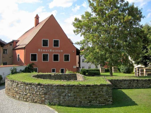
A late medieval house, standing directly over the southwestern wall sections of the fort, has been adapted as a branch museum of the Archaeological State Collection in Munich. It offers detailed insights into the history of Passau between Roman times and the early Middle Ages, as well as a general overview of the prehistoric and early historical epochs of Southeast Bavaria. The collection includes archaeological finds from East Bavaria (material from the forts of Moos and Künzing as well as from civilian settlements on the East Raetian Danube Limes), with the pieces from Passau forming the focus of the exhibition. Two rooms are designed as a lapidarium, where inscribed stones from Passau and the surrounding area are presented in original or as copies. In the basement, Roman foundations and wall remains have been uncovered, on which the museum building partly rests. The excavated parts of the foundations and the SW fan tower have been preserved and can be viewed on the museum's outdoor grounds. The archaeologically secured remains of the fort wall and the north gate under today's Lederergasse are marked by darker street paving.

Take Mobile History with you

You are reading this text for free. Premium adds what matters on the road: descriptions read aloud, sites found through your camera, whole regions taken offline.

  • Every description, including the ~17,700 Premium sites
  • Audio guide: have descriptions read to you on location
  • AR finder: see sites through your camera, with distance and bearing
  • Unlimited saved sites

14 days free, then from €2.99 a month. Cancel anytime.

Source: Wikipedia · Licence: CC BY-SA 4.0

This description draws on the facts documented in the linked Wikipedia article; Wikipedia content is licensed under CC BY-SA 4.0. Wording and editing: Mobile History.

Location: 48.5698, 13.4624