Ancient BuildingKempten

Roman Castle CAMBODVNVM (Camboduno)
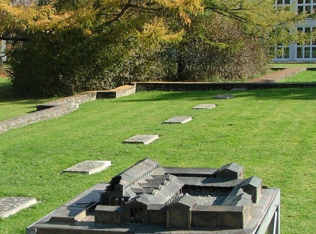
Roman Castle CAMBODVNVM (Camboduno)

The Roman Castle can be visited

Cambodunum is the name of the Roman settlement in the area of today's city of Kempten in the Allgäu. In the early and high imperial period, Cambodunum was one of the most important Roman cities in the province of Raetia and probably the first capital of the province before Augsburg (Augusta Vindelicorum). Kempten can therefore be counted among the oldest cities in Germany, alongside cities such as Trier (Augusta Treverorum) and Cologne (Colonia Claudia Ara Agrippinensium). The excavated and restored remains of the Roman city are presented on site as the Archaeological Park Cambodunum (APC). Finds from the city area are mostly located in the Roman Museum Kempten.

The core of the early and middle imperial settlement was located on the Lindenberg, an ice-age gravel terrace on the eastern high bank of the Iller (Hilaria). At this point, an Iller island (Burghalde) and a ford facilitated the crossing of the Iller (road connection to Brigantium/Bregenz). The demonstrable extent of the settlement is about 500 by 700 m.

It is unclear whether the current terrain edge corresponds to the ancient western city limit. It could have eroded away.

As an explanation for the incomplete city layout on the western edge of the Lindenberg, a terrain collapse due to an extraordinary flood in Flavian times is discussed. This is supported by layers with building rubble and Roman finds from the 1st and 2nd centuries at a depth of 1.5 to 3 m in Kempten's old town.

In late antiquity, the remaining settlement was moved to the more easily defensible Burghalde, then still a river island, under the protection of a military camp.

As documented by archaeologists of the city of Kempten, the Iller in antiquity flowed in several branches around the Iller island Burghalde, with the main arm being the left one, running approximately over today's town hall. During excavations in the area of the town hall square, twelve preserved oak trunks were found, originating from the Roman-era bridge. Dendrochronology dated them to the reign of Emperor Tiberius (14-37 AD). Around 1300, the main arm of the Iller was moved to its present bed, the area was filled in, and the city fortifications around the imperial city were gradually built. This served in particular to shield against the Kempten Abbey.

Etymology

Cambodunum is probably also the former name of Champéon (Cambdonno, Cambidonno – 9th century) and Chambezon (Chambedon – 11th century) in France, as well as an unidentified place in Great Britain. This archetype is of Celtic origin Cambo-dunum with the components cambo "curve", "loop", "meander" (e.g. Old Irish camb, camm "curve", "crooked", Breton kamm "bent", "askew") and dunon (*dūnon) "fortress", "castle", "mountain" (e.g. Old Irish dún "fortress", "fortification", Welsh dinas "city", Breton din). This word is closely related to the Germanic *tūna (English -ton, town, German Zaun).

Cambodounon therefore means approximately "city in a river bend" in Celtic. This Celtic name was adopted as the name of the Roman settlement in the spelling Cambodunum. The name of today's city of Kempten is derived from the medieval form Campidonum.

The Celtic Predecessor City

According to the geographer Strabo, the Celtic polis Cambodounon was the main settlement of the Estiones, a tribe of the Vindelici.

The Celtic city of Cambodounon mentioned by Strabo is considered archaeologically unprovable. Finds from the Late La Tène period, which immediately preceded the Roman occupation, are missing.

Other Roman city foundations with reference to Celtic predecessor cities took place at a relative distance and did not adopt their names (Augusta Vindelicorum/Augsburg 70 km away from Oppidum Manching and Castra Regina/Regensburg 21 km from Kelheim/Alkmoenis).

The Roman fort in Passau, however, adopted the location and name of its Celtic predecessor Boiodurum.

Early and Middle Imperial Period

In 15 BC, the pre-Alpine region came under Roman rule through Drusus and Tiberius (the later emperor). Shortly thereafter, the Roman Cambodunum was founded.

The city's boom in the 1st century was favored by its location on long-distance roads, especially by the connection via Chur and the Alpine passes there to Italy, as well as to Lake Constance and Roman Brigantium (Bregenz); see Allgäustraße. Along the Iller via Caelius Mons, today's Kellmünz, the Danube was reached in the north near Günzburg (Guntia). To the east, a Roman road ran to the Lech, which it reached near Epfach (Abodiacum) (connection to the Via Claudia Augusta).

The first wooden buildings in Cambodunum are traceable since the reign of Tiberius, stone buildings at the earliest from Claudian times. After the reign of Antoninus Pius, hardly any new constructions or alterations can be proven, and building activity probably gradually ceased.

Since 1885, the walls of a forum complex with a basilica and sacred district have been uncovered on the Lindenberg. The complex testifies to a high degree of municipal self-government, if it was not even the seat of the provincial diet, which has not yet been reliably localized in Raetia. This thesis is supported by the discovery of a Gallo-Roman temple district in the western part of the plateau, which could have served as a central sanctuary. Furthermore, two thermal bath complexes were excavated in the northeast, whereas a large part of the civil settlement remains unexplored. Thus, especially the peripheral areas of the city, its suburban areas, and the cemeteries of the 2nd and 3rd centuries are unknown. Therefore, considerations about the size and population of Cambodunum are difficult.

Late Antiquity

Under the sustained pressure of invading Germanic tribes, the urban settlement on the Lindenberg was abandoned at the latest by the end of the 3rd century. The population sought refuge on a flood-free terrace west of the Iller below the so-called Burghalde, a ridge rising about 25 m from the Iller valley. The greatly reduced settlement (1 ha) was now protected by a side arm of the Iller. In addition, a wall about 1.8 m wide was erected, whose course is only secured in the west due to medieval and modern superstructures. Another wall, whose dating is disputed, protected the higher Burghalde plateau.

Finds from these areas are rare. The most important late antique sites in Kempten are the inhumation cemeteries north of the late antique settlement and on the western bank of the Iller ("auf der Keckwiese"). Of these, the latter is more likely to be considered civil due to the strong predominance of female burials.

With the loss of the Decumates Agri, Kempten had become a border town. From Kempten to the mouth of the Iller, the imperial border ran along the river. Most likely, the detachment of Legio III Italica mentioned in the Notitia Dignitatum was stationed in the higher area of the Burghalde (0.7 ha). The fortification was integrated into the late Roman border defense on the so-called Danube-Iller-Rhine Limes. In contrast to the Limes of the middle imperial period, the border fortresses were significantly smaller, but adapted to the environment in terms of fortification. Illustrative examples of such fortifications could be archaeologically investigated in the two neighboring forts of Isny (Vemania) and Kellmünz (Caelius Mons).

The beginning of the stationing on the Kempten Burghalde should be placed in the time of Diocletian's reforms around 300. A military find from a small residential house proves the presence of soldiers at the beginning of the 5th century. The military garrison was probably abandoned by the middle of the century at the latest.

Research History+

The first archaeological excavations in Kempten took place in 1885 by the merchant August Ullrich. Further excavations were carried out until 1911 by the Kempten Antiquities Association, founded the year before. They were continued from 1912 to 1935 by the Bavarian State Office for Monument Preservation under Paul Reinecke. Against the protest of monument preservation, a large part of the archaeological monuments of the Roman city on the Lindenberg fell victim to the construction measures of this period under Mayor Otto Merkt. The excavations made it possible for the first time to obtain a picture of the structure of the settlement on the Lindenberg.

The cemetery "Auf der Keckwiese" was excavated from 1952 to 1967. Since 1961, the Roman-era finds have been presented in the Roman Museum Kempten in the Zumsteinhaus. The city of Kempten promoted the research of the Roman city since 1982 by establishing an office for urban archaeology. Several follow-up investigations, including those at the Gallo-Roman temple district in 1983/86, served to establish the Archaeological Park Cambodunum (APC). This was opened in October 1987 with a first section (Gallo-Roman temple district).

Roman Buildings+

The city's street system was laid out along a central Decumanus, which originated from the altar in the sacred district of the forum. A Cardo, perpendicular to the Decumanus, is evidenced by the so-called Thermenstraße (Bath Street). Of the city's residential buildings, several of the younger stone construction phases have been identified, especially in the center. Nine complexes can be described as insulae, which were 20–45 m wide and up to 80 m long. West of the forum, there was a small suburb consisting of so-called strip houses. Craft businesses, especially potteries, settled in the peripheral areas of the city.

Forum and Basilica

The forum, which dominated the cityscape, was not built in one go. The "older forum" as the first stone construction phase was preceded by one or two wooden construction phases, which were identified by subsequent excavations in 1985 in the area of the basilica. The older forum was essentially excavated in 1885/86. The complex included the freestanding basilica (initially 49.5 x 25 m) and a building with a larger suite of rooms, probably to be regarded as an administrative and assembly room. A sacred district adjoined to the southeast. It was surrounded by a wall enclosing an area of 600 x 800 Roman feet. Centrally located within it is an altar building measuring 8.4 x 12 m. The buildings had ornamented marble cladding and paintings. Parts of these were discovered as "forum rubble" in other city districts.

The construction of the younger forum is likely to have begun in the Flavian period. These alterations to the forum were probably completed by the middle of the 2nd century. A representative facade with access in the form of a propylon replaced the old forum buildings facing the forum street. The forum square was now built up on all sides, while the large square with the altar and the basilica remained. A striking feature is a building on the south side with an apse, which may have served as an assembly room (curia) for the city council (ordo decurionum), as well as the forum temple on the northwestern narrow side.

To the northeast, a larger building, interpreted as a lodging house (praetorium), was added from the early 2nd century. It initially had several larger suites of rooms of up to 140 m², which were divided into numerous smaller chambers between 12 and 20 m² after a renovation in the early 2nd century.

Gallo-Roman Temple District

In the northwest of the city, near the steep slope by the Iller, a temple district has been uncovered since 1937/38. It was located in the vicinity of the so-called bathhouse. Simultaneously with the conversion of this building into a tavern around the middle of the 2nd century, stone buildings replaced earlier wooden structures in the temple area. A U-shaped double hall enclosed the area, which was open to the north towards the steep slope, from the city. Within it were twelve buildings, though not all must have existed simultaneously. Building 4, a Gallo-Roman ambulatory temple, and a larger building with a later added apse, are important for understanding the complex. The numerous smaller buildings could have served as treasuries for votive offerings.

Baths

In addition to the bathhouse, which functioned as a small bathing facility since the reign of Caligula, the city possessed larger thermal bath complexes northeast of the forum. These bathing facilities are among the earliest structures of their kind north of the Alps. The bathhouse is considered the earliest stone building in Kempten and was uncovered by Paul Reinecke in 1913. The proximity of such a building to a cultically used facility is not a contradiction, as numerous examples of coexistence in other Roman settlements show.

The "small baths" connect to the lodging house at the forum with the palaestra. Three wooden construction phases are known for the building, whose beginning is dated to the late Claudian or early Neronian period. It was originally a "row-type" bath, with rooms for the three stages caldarium, tepidarium, and frigidarium arranged linearly one behind the other. Later, additional stoking rooms, a sweat bath, and a latrine were added to the bath. Access was initially only possible via the praetorium, suggesting an affiliation with the governor's residence.

The "large baths" were built towards the end of the 1st century at the northeastern end of the "Thermenstraße" (Bath Street). With an area of 4200 m², they are among the largest thermal bath buildings north of the Alps. Their size was only surpassed by the large thermal bath complexes of the 2nd century and late antiquity, including the baths of Colonia Ulpia Traiana (Xanten), the Barbarathermen, or the Kaiserthermen in Trier. At this time, the large baths in Kempten already underwent a conversion or reconstruction, which reduced the covered area by about one fifth.

Cemeteries

Of the cemeteries from the early and middle imperial period, the one located north of the city "auf der Keckwiese" near the Keckkapelle is particularly well researched. The majority of the over 400 burials date from the 1st century, with some extending to the end of the 2nd century. In some cases, above-ground tomb structures and grave enclosures are demonstrable.

Around the middle of the 4th century, the area was again used for burials. In the northern part, 38 largely grave-good-free inhumations were found, which overlay some older cremation burials, and showed fire debris from destroyed early and middle imperial graves in their backfill. Both the lack of military equipment among the finds and the gender ratio (male : female = 5 : 12) suggest a civilian character of the cemetery.

Further cemeteries are presumed east and south of the city. Individual graves were discovered in 1862 during the construction of Kempten's Ostbahnhof. South of the city, such finds are currently unknown.

A smaller inhumation cemetery under today's Rathausplatz belongs to the late antique settlement on the Burghalde.

Late Antique Buildings

At the foot west and north of the Burghalde, a 1.8 m thick wall and a single associated tower were identified. The fortification enclosed an inner area of just under 1 ha and probably belonged to the late antique civil settlement. The only building that could be definitively identified was a presumed residential house measuring 5 x 9.5 m. On the plateau of the Burghalde, with a length of 130 m and a width between 20 and 95 m, two wall sections are attributed to the late antique fortification, when the city was a stationing site for a detachment of Legio III Italica.

Whether there was still a settlement on the Lindenberg, located east of the Iller, in late Roman times is not certain due to a lack of clear settlement finds. Late antique glass and coin finds and little pottery only indicate a slight continued settlement. The late antique reuse of the cemetery "auf der Keckwiese" would also support this.

Take Mobile History with you

You are reading this text for free. Premium adds what matters on the road: descriptions read aloud, sites found through your camera, whole regions taken offline.

  • Every description, including the ~17,700 Premium sites
  • Audio guide: have descriptions read to you on location
  • AR finder: see sites through your camera, with distance and bearing
  • Unlimited saved sites

14 days free, then from €2.99 a month. Cancel anytime.

Source: Wikipedia · Licence: CC BY-SA 4.0

This description draws on the facts documented in the linked Wikipedia article; Wikipedia content is licensed under CC BY-SA 4.0. Wording and editing: Mobile History.

Location: 47.7267, 10.3265