The Roman Castle can be visited
Roman Castle Holzheimer Unterwald (Pohlheim)
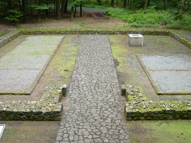
The small fort of Holzheimer Unterwald is a former Roman border fort on the Wetterau line of the Upper Germanic Limes, which has held UNESCO World Heritage status since 2005. The former auxiliary fort is now a preserved and partially reconstructed archaeological monument in a forest area of the Großen-Lindener Hügelland, northwest of the Wetterau towards the Lahn Valley of the Gießen Basin. It is located in the municipality of Pohlheim in the Hessian district of Gießen, between the Pohlheim districts of Holzheim and Grüningen and the Langgöns district of Lang-Göns.
Historical Background+
Even at the beginning of the Roman attempts to occupy the Germanic territories beyond the Rhine, the Wetterau was in an exposed position. During Drusus' campaigns (12 to 9 BC), it was the staging area for the advance against the Chatti, which began in 10 BC from the legionary camp of Mogontiacum. In Tiberian times, however, with the recall of Germanicus in 16 AD, expansion efforts were initially halted and military installations abandoned. For the next few decades, the Rhine once again formed the border between the Roman Empire and the Germanic tribal territories.
Only under Vespasian (69–79) was the region re-occupied by the Romans and covered with a network of forts and road connections, to secure the fertile Wetterau itself as well as the Main Valley. After the conclusion of Domitian's Chatti Wars (83–85), the expansion of the Limes finally began, of which the small fort "Holzheimer Unterwald" was a part. Initially consisting only of simple clearings cut into the forest, it was increasingly expanded and reinforced from the Trajanic period onwards.
In the second half of the second century AD, Germanic pressure on the borders of the Empire increased. This was also noticeable in the Wetterau, both in the form of smaller raids and serious military advances, during which the Limes was repeatedly overrun. Following the last major Germanic attacks in 259/260, the Romans finally evacuated the area east of the Rhine and with it the Limes forts.
Location+
The small fortification is located directly on the Limes, in the small forest "Holzheimer Unterwald", a few meters west of the district road (K 162) from Grüningen, which 200 m south flows into the state road (L 3133) connecting Langgöns with Holzheim. It is a point of interest on the tourist German Limes Road. In front of the Limes wall, in the former Limes ditch, there is now a forest path that marks the boundary between Pohlheim and Langgöns.
In ancient times, the small fort was part of an 8.5 km long, straight section of the Upper Germanic Limes running from southwest to northeast, between watchtowers Wp 4/33 (near Butzbach) and Wp 4/49 (not far from the small fort of Hainhaus). Although the straight course of the Limes itself did not take topographical conditions into account, the location of the fort seems to have been chosen with care. The garrison was probably responsible for monitoring border traffic, which can be assumed to have existed in the area of the pass, now used by the L 3133, in ancient times and possibly led directly through the fort in its early period. towards the northwest in the direction of the Lahn, enabling effective forward surveillance and security of the sensitive, northward-projecting Limes arc on its northwestern flank.
Research History+
The fort "Holzheimer Unterwald" was first mentioned in writing in 1843 in the prehistory of the Wetterau, written by Johann Philipp Dieffenbach (rector of the Friedberg Augustinian School and one of the most important regional antiquarians of his time). From 1879, the first excavations were carried out by Gießen Professor Carl Gareis, a lawyer, which were not sufficiently professional and therefore poorly documented and incorrectly interpreted. Various ambiguities led to subsequent investigations, which were carried out in 1894 by the Imperial Limes Commission under the local direction of district commissioner Friedrich Kofler.
Intensive looting, which took place in the remote and therefore difficult to control area since the early 1970s and seriously threatened the existence of the archaeological monument, prompted the Archaeological Heritage Conservation in the Hessian State Office for Historic Preservation to carry out archaeological rescue excavations between 1988 and 1991, led by Gabriele Seitz. Finally, in 1995, the site was carefully partially reconstructed and preserved by the Archaeological Society in Hesse e.V.
Findings and Interpretation+
The small fort "Holzheimer Unterwald" is a stone fortification with an approximately rectangular ground plan. With side lengths of about 18.60 m by 19.40 m, it occupies an area of approximately 360 m², with an effective internal usable area of just under 290 m². At the time of its construction, the total area required, including the ditch in front, was slightly over 600 m², which corresponded to half an actus quadratus. With this area, it is one of the smallest installations of its kind on the Upper Germanic Limes. Through the investigations from 1988 to 1991, a total of two construction phases could be differentiated, but not precisely dated.
The fort was fortified with a roughly 100 cm thick, double-shell wall made of basalt stones of regional provenance. In contrast to most Limes forts, the corners of the defensive wall were not rounded, but sharply angled. Immediately in front of the wall, separated from it only by a narrow berm, ran a two-meter-wide and one-meter-deep pointed ditch. The fortification was oriented with its front to the northwest, towards the Limes. Here was a passage 2.50 m wide with 1.80 m long, recessed gate cheeks. Above the gate passage rose the fort's only watchtower. On the rear, southeastern side, there was another access in the form of a postern gate only 1.20 m wide.
The interior of the fort was divided into two halves by a fortified camp street, in each of which stood a timber-framed barracks. Facing the camp street, each barracks had an approximately 1.50 m wide portico. In each of these troop quarters, 13.80 m long and 3.60 m wide, there were four single-room contubernia (mess groups). Each mess group thus had an area of just over 12 m², within which sleeping, cooking, and eating took place. It is assumed that a maximum of four soldiers were accommodated per contubernium and that the total occupancy of the small fort was between 20 and 30 soldiers. Whether all rooms were actually used for accommodating the troops or whether some part might have housed riding animals must remain open, as the condition of the findings during the most recent excavations no longer allowed clarification of the question of whether all rooms had a hearth.
In a later phase, the fort was redesigned. The rear postern gate was walled up, and the southwestern barracks was reduced by two rooms in its southern part. In the resulting undeveloped area, a well 9.50 m deep was dug. A square well shaft with a side length of 1.10 m was placed in the circular excavation pit of 2.0 m diameter. The reconstruction measures suggest a reduced troop strength, but possibly also a changed self-perception and self-confidence of the Limes troops. The need for security seems to have increased significantly, as indicated by both the closing of the fort's rear and the securing of the drinking water supply.
Find Material and Dating+
The most spectacular find from the fort is certainly the hoard of a small coin treasure, consisting of a total of 35 coins, of which 34 are silver denarii and one sestertius made of a copper alloy. The coin series begins with a coinage of Vitellius from 69 AD and ends with a coin of Marcus Aurelius for his wife Faustina, which must have been minted no later than 176 AD. Further, a total of 14 individual coin finds consist of denarii, sestertii, and asses of the emperors Vespasian, Trajan, Hadrian, and Antoninus Pius. The oldest coin here also dates from 69 AD, the latest was minted in 161 AD.
The abundance of pottery finds was unusually high. South Gaulish Terra Sigillata, in conjunction with the construction features of the fort, makes an erection in the Trajanic period probable. Central and finally East Gaulish Terra Sigillata from the pottery centers of Augusta Treverorum (Trier) and Tabernae (Rheinzabern) prove its continuous existence until the first third of the third century. Isolated shards of rough-walled Urmitz ware finally prove its existence even in the second third of the century. The time of the reconstruction can only be approximately estimated based on the historical context. It probably falls into the period of increasing threat from the Germanic tribes and the last phase of the Limes expansion. Thus, it would be dated to the second half of the second century.
Among the finds, a Germanic shield boss is also noteworthy, which, together with the finds of Germanic pottery, documents the increasing presence of Germanic peoples in the Roman-occupied border area from the second half of the second century onwards.
Nothing is known about the name and origin of the troops stationed in "Holzheimer Unterwald". Due to the distances, the auxiliary troops of Fort Arnsburg as well as Fort Butzbach are fundamentally considered as the parent units that detached this vexillatio (detachment). Through so-called graffiti (name markings scratched into the glossy coating of Terra Sigillata vessels), with which the auxiliaries marked their personal eating utensils, the names of four soldiers are fragmentarily preserved: MAT[ternus?], a VICT[or] or VICT[orinus], a [----]IVS and a [----]VPI.
Trivia+
The name of the large municipality formed in 1971 and today's city of Pohlheim goes back to a village named "Pfahlheim" (in dialect "Pohlheim" or "Pfuhlheim") mentioned as early as 793 in the Lorsch Codex, but which disappeared in the Middle Ages, located in the municipality's territory. This name, in turn, referred directly to the Limes (Pohl = Pfahl = palisade ditch). The reconstructed watchtower Wp 4/49 became part of the newly formed city coat of arms. The name of Pohl-Göns, located a few kilometers south on the Limes (1250 as "Palgunsin"), also goes back to the palisade ditch.
In the immediate vicinity of the reconstructed watchtower is the so-called "Barbarenstein" (Barbarian Stone), a memorial stone that the director of the Gießen psychiatric hospital, Robert Sommer, had erected here with his wife in 1912. The name "Barbarenstein" derives from the inscription on the stone:
MEMORIAE ROMANORVM BARBARVS ANNO MDCCCCXII
Translated: "To the memory of the Romans, a Barbarian in the year 1912."
The inscription on the back reads LIMES IMPERII ROMANI ("Border of the Roman Empire"). On the narrow sides are the details ROBERTVS SOMMER CVM VXORE ("Robert Sommer with wife") and CIVIS GISSENSIS ("a citizen of Gießen"). Sommer had acquired land on the Limes to prevent its impending destruction by continued agricultural use. This behavior and the erection of the stone provide a small insight into the historical understanding of bourgeois circles before the First World War.
The small fort is a station on the Pohlheim Limes hike, which has taken place annually since 2006.
Take Mobile History with you
You are reading this text for free. Premium adds what matters on the road: descriptions read aloud, sites found through your camera, whole regions taken offline.
- Every description, including the ~17,700 Premium sites
- Audio guide: have descriptions read to you on location
- AR finder: see sites through your camera, with distance and bearing
- Unlimited saved sites
14 days free, then from €2.99 a month. Cancel anytime.
Source: Wikipedia · Licence: CC BY-SA 4.0
This description draws on the facts documented in the linked Wikipedia article; Wikipedia content is licensed under CC BY-SA 4.0. Wording and editing: Mobile History.
Location: 50.4998, 8.6994