Ancient BuildingMarköbel

Roman Castle Marköbel
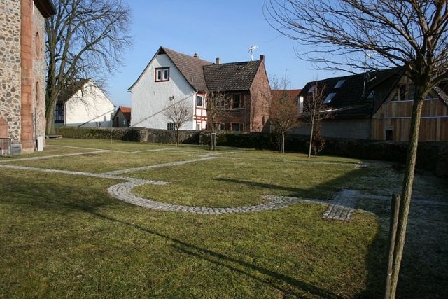
Roman Castle Marköbel

The Roman Castle can be visited

Kastell Marköbel is a former Roman fort on the Wetterau line of the Upper Germanic-Rhaetian Limes in Marköbel, municipality of Hammersbach, in the Main-Kinzig district. Today, apart from some reconstructions, nothing of the complex is visible.

Marköbel is located in the Ronneburger Hügelland, which forms the eastern edge of the Wetterau as a western spur of the Vogelsberg. The medieval village center and the fort are situated on a hill running from west to east, rising between 10 and 25 meters above the Krebsbach stream and its tributaries.

Already in pre-Roman times, a path passed through this area, leading from the Lower Main region along the southern low mountain range edge into the Fulda basin, where a larger Germanic settlement area was located during Roman times. In the Middle Ages, this so-called Hohe Straße (High Road) also had significance as part of the Via Regia.

At the crossing of the road over the Krebsbach, there was also a Limes crossing, for the control of which the fort was built at this location. Its eastern part is located under the medieval and modern village center of Marköbel and is almost completely built over.

Findings+

Due to its favorable location, a fort was sought here as early as the 19th century. Interest was aroused by the field names "große Burg" (large castle) and "kleine Burg" (small castle) outside the medieval town wall, as well as the ridge west of Marköbel, where Georg Wolff and August von Cohausen carried out field surveys in 1881. After Wolff was able to prove the existence of the fort near the village in 1884, it became clear that the remains of the fort's vicus had been investigated previously. Excavations followed under Wolff's direction by the Reichs-Limes-Kommission (RLK) in 1892 and 1893.

In the 20th century, large parts of the fort and the civilian settlement were built over without further archaeological investigations taking place. In 1951, the foundations of the bathhouse were discovered by Hugo Birkner under the Protestant church during the installation of a heating system. These were partially excavated by Karl Dielmann between 1963 and 1965.

The last undeveloped fort area in the northwest was investigated in 1983 by the State Office for Monument Preservation Hesse and the Hanauer Geschichtsverein before the construction of the new cemetery.

Fort

The stone fort, proven by Wolff, had a size of 3.3 ha and was oriented to the east, towards the Limes. Of the gates, the rear gate (porta decumana) and the left side gate (porta principalis sinistra) were uncovered by the Reichs-Limes-Kommission. The fort was surrounded on all sides by a double pointed ditch, the inner one with a width of 9 m, the outer one 11 m, both with a depth of 2 m. Evidence of one corner and several intermediate towers would, with a regular arrangement, result in four corner and ten intermediate towers. Crenellated coping stones made of Büdingen sandstone prove the control of the Limes foreland by the Roman troops. The 1.20 to 1.30 m wide wall consisted of cast masonry.

The fort's ground plan can still be traced in the townscape by the course of the main and northern streets. Today's Römerstraße passes just past the porta decumana and merges into Lindenstraße in the area of the headquarters building (principia). In the flag sanctuary of the principia, the index finger of a larger-than-life bronze statue was found during the excavations. This probably belonged to the emperor's statue once erected here. The fragment is dated to the 2nd to mid-3rd century AD.

Significant parts of the interior buildings are only available from the rear area of the headquarters building, which was uncovered in the area where Römerstraße and Lindenstraße meet. The flag sanctuary and three adjoining rooms with porticoes were investigated. Further remains of the interior buildings, which probably largely consisted of half-timbered structures, could only be investigated to a lesser extent. A piece of Roman wall stands today without explanation of its context in the New Cemetery, where there are also two information boards.

The 1983 excavations provided evidence of a predecessor building in wood-earth construction, which was congruently located under the wall of the stone fort. An corner tower and several intermediate towers of this structure were proven.

The garrison of the fort cannot be deduced from the finds, especially due to a lack of inscription finds. Due to its size (for comparison: Saalburg stone fort 3.2 ha), a partially mounted cohort or an ala with a strength of 500 men would be assumed.

Dating

In addition to the wood-earth fort, there are various indications for dating Kastell Marköbel to the early period of the Limes, i.e., to the time of Emperor Domitian. The kilometer-long straight stretches of the Limes north and south of Marköbel up to the bend at the crossing east of the fort are striking. They suggest that the complex already existed when the Limes was built and surveyed.

Finds of South Gallic Terra sigillata and brick stamps of the Legio XIIII Gemina, which was withdrawn from Mainz to the Danube around 97 AD, support an early dating. New finds of two forts near Hanau-Mittelbuchen prove that there were still minor border shifts on the Wetterau Limes in the early period.

The stone fort would then have been built under Emperor Hadrian (117–138).

Bathhouse

The location of the fort bath, partially excavated between 1963 and 1965, has been indicated with natural stones in the courtyard behind the Protestant Church and provided with information boards. Visible on the outside are primarily the heated bathing rooms; the cold bath (frigidarium) is located under the church choir. A large number of found brick stamps allowed the construction to be dated to the beginning of the 2nd century. A major renovation is evident towards the end of the 2nd century.

Civilian Settlement and Cemetery

Only a few findings from the fort's vicus have been systematically excavated. It was located along the roads leading out of the fort to the west and south. This includes a hall building on the western edge of the present-day village, which may have served as a sanctuary, as well as four stone cellars below the southern fort gate.

In 1884, a brick kiln was discovered in Römerstraße, but its bricks were not stamped.

Towards the end of the 19th and in the first half of the 20th century, a total of 45 cremation graves were recovered during construction work in Urnenstraße, proving the only known cemetery of the fort.

Take Mobile History with you

You are reading this text for free. Premium adds what matters on the road: descriptions read aloud, sites found through your camera, whole regions taken offline.

  • Every description, including the ~17,700 Premium sites
  • Audio guide: have descriptions read to you on location
  • AR finder: see sites through your camera, with distance and bearing
  • Unlimited saved sites

14 days free, then from €2.99 a month. Cancel anytime.

Source: Wikipedia · Licence: CC BY-SA 4.0

This description draws on the facts documented in the linked Wikipedia article; Wikipedia content is licensed under CC BY-SA 4.0. Wording and editing: Mobile History.

Location: 50.2227, 8.9842