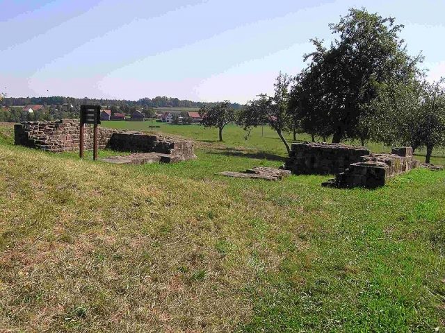
The remains of the roman Castle can be visited
Roman Castle Oberscheidental

The Oberscheidental fort is a former Roman cohort fort of the older Odenwald line of the Neckar-Odenwald Limes. The present-day archaeological monument is located on the southeastern edge of the village center of Scheidental, a district of the Baden-Württemberg municipality of Mudau in the Odenwald.
The high plateau on which the garrison was stationed forms the watershed between the Main and Neckar rivers. It is the source region of the Elz, Galmbach, and Reisenbach, which flow into the Neckar, and the Teufelsklinge, which flows into the Main. In ancient topography, the Elz and Teufelsklinge were natural connections to unconquered Germania, while the Galmbach and Reisenbach led into the interior of the Empire. While the Numerus fort in Schloßau may have been sufficient to secure the less significant Teufelsklinge, the cohort in Scheidental may have been deemed necessary to monitor the wider and easily passable Elz valley.
In the current village layout, the fort lies east of the village center, in the "Burgmauer" district, an area only partially built up on the west by a meadow between the village center and the cemetery, south of "Kastellstraße". The praetorial front (front side) borders the cemetery, the left side front lies under the road to Unterscheidental. The fort baths are located approximately 41.50 m from the southwest corner of the camp, beyond "Eberbacher Straße" (L 524).
Research History+
The fort area had been known as a site of Roman relics since the first half of the 19th century. The Buchen Antiquities Association first expressed suspicions about its military character in 1863. However, these considerations did not lead to practical excavations, as at that time, following the hypotheses of Christian Ernst Hanßelmann and Friedrich Knapp, the Limes was presumed to run on a line from Schloßau via Mudau to Osterburken. Only through the efforts of the private scholar Karl Christ (1841-1927) and the Mannheim Antiquities Association was the area south of Schloßau more thoroughly investigated by the Hessian-Baden Limes Commission starting in 1880. The cohort fort was located as early as July 1, 1880. The first excavations took place in 1883, followed by the restoration of the Porta Principalis Dextra and further investigations inside the fort in 1886. Finally, in 1895, supplementary excavations were carried out by the Imperial Limes Commission.
Findings+
Fort
The camp follows the usual chronological scheme of the entire older Odenwald line, meaning it was occupied from the Trajanic period until no later than 159. Founded as a wood-and-earth camp under Trajan, it was provided with a dry stone wall in the Hadrianic period and a mortar wall between 140 and 150. Suggestions that its origins might date back to the Domitianic period could not be archaeologically substantiated. In fact, only a single construction phase could be definitively proven through excavations. This is a stone fort built from the region's typical Bunter sandstone, covering an area of approximately 2.1 hectares.
The fort had an approximately rectangular ground plan. The length of the praetorial front is 134.5 m, that of the decuman front (rear front) is 137 m. The northern side flank is 152 m long, the southern 153 m. The corners of the fort wall were rounded with a radius of about 16 m. The foundation of the defensive wall was 1.60 m wide and consisted of mortared Bunter sandstone blocks. It rested on a mortarless rolling layer. The rising masonry receded on the inside and outside and had a thickness of 1.30 m at the bottom and 1.20 m at the top. At the corner curves, it projected outwards up to 1.40 m thick. It was constructed as a shell wall. The outer shells consisted of carefully crafted, horizontally layered ashlar blocks 40 cm to 65 cm long, 22 cm to 25 cm high, and 20 cm to 30 cm deep. In the core, not the expected Opus caementitium was found, but sandstone rubble bonded with lime mortar.
All fort corners were fortified with towers, and a ditch one and a half meters deep and six meters wide ran around the fort as an approach obstacle. Immediately behind the fort wall was an earthen rampart 5.5 m to 7.5 m wide, which supported the rampart walk. At its base, the rampart was bounded by the approximately 3.8 m wide via sagularis (camp ring road). Of the four gates, also equipped with towers, the Porta Praetoria was oriented to the east, towards the Limes, which ran only about 25 m away. The Porta principalis dextra, facing south, was the best preserved; it was excavated and conserved.
From the interior buildings, the Principia (headquarters building) with the flag sanctuary (Aedes or Sacellum), a small bath building, and, in the southern part of the Praetentura (front camp area), another large building could be localized. The Principia covered an area of 52.80 m by 41.70 m, with the flag sanctuary projecting 3.10 m from the wall line at its rear. The Sacellum was rectangular and consisted of two different rooms. A basement under the Sacellum, as was common for housing the troop treasury, could not be found in Oberscheidental. The inner courtyard of the Principia was about 21 m wide and continuously paved. The small "Bath Building B" consisted of only two rooms and contained a single water basin. The large "Building C" occupied an area of 10.80 m by 20.41/20.75 m. Due to the accumulation of cultural waste found there, it is probably a residential building, which has been identified as a Praetorium (commander's residence). However, a Horreum (granary) at this location in the camp cannot be ruled out either.
Baths, Vicus and Cemeteries
West of the camp, traces of the fort's vicus (civilian settlement) were found; the fort bath was located 41.50 m southwest of the camp's southwest corner. Its southeastern corner was completely destroyed in the first half of the 19th century during the construction of the road to Eberbach. However, the ground plan of the baths could still be fully documented during the investigations by the Imperial Limes Commission. The complex occupied an area of 20.40 m (north side) by 34.35 m (east side).
Occupation+
Two different, chronologically successive cohorts (each approximately 480 men) could be clearly assigned to the Oberscheidental auxiliary fort. Initially, the Cohors III Dalmatarum (3rd Dalmatian Cohort) was stationed here, which had been stationed in Upper Germania around 88/89 and had reached Oberscheidental via intermediate stays in Rottweil (Arae Flaviae) and Wiesbaden (Aquae Mattiacorum). When it was transferred to the Rückingen fort on the Wetterau Limes around 120, it was replaced by the Cohors I Sequanorum et Rauracorum equitata (1st partially mounted cohort of the Sequani and Rauraci). The latter was commanded to the Miltenberg-Altstadt fort around 159 with the eastward shift of the Limes.
State of Preservation+
Clear traces of the fort are still visible in the terrain, and the conserved Porta principalis dextra is exposed. However, nothing of the vicus and the fort bath is perceptible anymore. Both are likely to have been severely disturbed by modern construction, namely by the construction of the road to Eberbach.
Take Mobile History with you
You are reading this text for free. Premium adds what matters on the road: descriptions read aloud, sites found through your camera, whole regions taken offline.
- Every description, including the ~17,700 Premium sites
- Audio guide: have descriptions read to you on location
- AR finder: see sites through your camera, with distance and bearing
- Unlimited saved sites
14 days free, then from €2.99 a month. Cancel anytime.
Source: Wikipedia · Licence: CC BY-SA 4.0 · Image: http://commons.wikimedia.org/wiki/File:ORL52_Kastell_Oberscheidental_1.jpg?uselang=de
This description draws on the facts documented in the linked Wikipedia article; Wikipedia content is licensed under CC BY-SA 4.0. Wording and editing: Mobile History.
Location: 49.5064, 9.1527