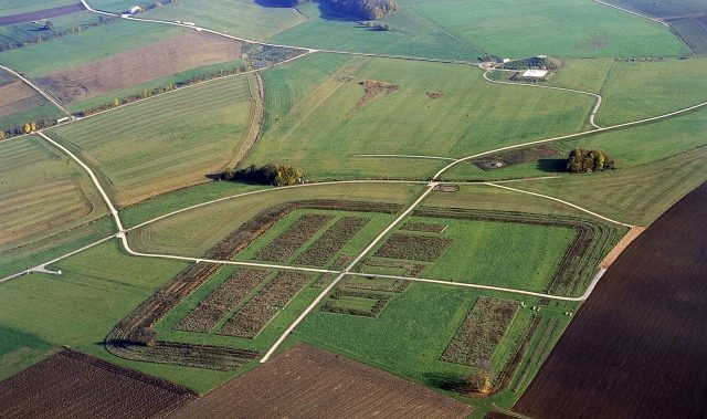
The Roman Fort can be visited
Roman Castle Ruffenhofen

Kastell Ruffenhofen is a former Roman military camp, built near the Raetian Limes, a section of the Upper Germanic-Raetian Limes, which has been designated a UNESCO World Heritage Site. Today, it lies unexcavated beneath the fields of Ruffenhofen, located about 800 m southeast, which belongs to the market town of Weiltingen in the district of Ansbach in Bavaria.
Location+
The former garrison is situated in a hilly landscape, about 30 to 35 m above the Wörnitz river, which flows northeast, on a small, northwest-oriented spur of land that gently slopes down into the river valley. Within sight, about 1.5 km north, the Wörnitz makes an almost right-angled turn sharply to the southeast. At this point, the Sulzach river, flowing down from Free Germania, also meets the Wörnitz from the northwest, and the Hesselberg, a prominent west-east oriented mountain, rises steeply on the northern bank of the Wörnitz. Behind the fortification, the long-distance view is obstructed by the hilly landscape. On the northern slope of the spur occupied by the fort, the Denzenbach stream flows into the river valley; it was important for the fort's water supply.
The complex was built at a militarily advantageous location for observing the border installations, which were about 2.2 km away. From here, an extensive section of the Limes could be kept under observation, between watchtowers Wp 13/8 in the "Weiltinger Forst" and Wp 13/25 near the present-day hamlet of Grüb. This allowed, among other things, the river crossing of the border installations in the southwest near Wp 13/12 to be seen, and the subsequent course of the Limes towards the northeast on the heights of the opposite Wörnitz bank was clearly visible. For further long-distance communication, research assumes a signal station on the Hesselberg. From there, it would have been possible to exchange messages with the Numerus fort Dambach and the Numerus fort Unterschwaningen, which was probably abandoned during the founding period of Ruffenhofen.
Research History+
The first excavations are known from 1868. In September and October 1892, extensive investigations were carried out by the Imperial Limes Commission (RLK) under section commissioner Wilhelm Kohl on the site, which was already heavily degraded by agriculture and stone quarrying. In 1917, an emergency excavation followed in the vicus (camp village). Only regular aerial surveys since 1977, magnetic field measurements from 1998, and the earth resistance measurement carried out here for the first time in 2004 could significantly supplement the RLK's excavation findings. However, a modern, comprehensive excavation-technical survey of the site has not taken place since 1892, so many questions, including those about dating, remain speculative. Therefore, Ruffenhofen, along with Kastell Oberhochstatt, is one of the least researched fortifications of the Raetian Limes, which even the smaller soundings carried out in 2005 on the fort wall – the first since 1892 – and the four ditches have not changed.
Since 2002, the Office for Rural Development Ansbach has been purchasing former agricultural land under which the fort lies. Until 2003 still under cultivation, the largest part of the fortification was declared "Römerpark Ruffenhofen" to promote tourism in the surrounding communities, as decided by the local special purpose association "Römerkastell Ruffenhofen", founded in 2001. Grass was sown on the ground above the ruins. Differently colored flowerbeds, trimmed hedges, and pathways indicate known structures and buildings of the fort in a park-like atmosphere. A newly built mound offers a clear view of the park. Nothing of the actual ancient buildings is visible at the fort; instead, a 20 m × 20 m labyrinth with granite stones, lawns, and a lime tree in the center of the labyrinth was created on the site in 2009 as a visitor attraction.
Construction History+
The almost square, 190 × 197 m (= 3.7 ha) large stone fort of Ruffenhofen stands out due to its size as the most important complex between the Ala fort Aalen and the Ala fort Weißenburg. The surveyors oriented the praetorial front, the side of a fort facing the enemy, towards the northeast, towards the Hesselberg. The approximately 1.5 m wide rampart of the complex, fronted by an earth ramp, was rounded at the four corners and had a corner tower at each.
As could be determined during the 2005 sounding, the defensive walls consisted of sandstone ashlar blocks, which came from various local quarries. The wall foundation was based on stones of various kinds. Since mortar residues were found on these stones, it is assumed that they were reused. On the northeast wall, there were two intermediate towers to the right and left of the Porta praetoria, while on the southeast defensive wall, there was only one in the area of the retentura. The findings were mirrored on the northwest rampart. Only the rear facade of the fort seems to have had no intermediate towers. Three gates of the complex had two-lane access roads, each with two gate towers. Only the rear Porta decumana was, according to the assumed standard scheme for fort construction, equipped with only one passage between the two gate towers.
As an obstacle to approach, the garrison was initially secured with a double ditch. The innermost ditch, almost 3 meters deep, was not designed as a V-shaped ditch, but at a very shallow angle, as otherwise the defensive wall, which lay directly in front of this ditch, could have slipped. Only later, possibly in the 3rd century, two further, but not as deep, ditches were laid around the fort. In the outermost ditch, excavators in 2005 found loose Roman-era horse bones, which yielded an almost complete animal. The bones were probably thrown into the ditch after a meal during an unusual situation. At least for the most part, these ditches probably ceased at the four access roads.
The Principia, the staff and administration building of the fort, also followed the known pattern. They had a large multi-purpose hall, which lay with its long side over the Via principalis, connecting the southeast and northwest gates. Behind this hall was the rectangular inner courtyard with the surrounding service rooms in a square. In the rear building block, located on the Via quintana, the shrine of the standards (Aedes) was centrally located. In total, four stone buildings have been identified in the central strip of the camp so far. The soldiers' living barracks, however, were built of wood. Four double barracks with 2 × 12 squad rooms and the associated head buildings, where the Centurion and possibly other officers/non-commissioned officers, as well as servants, lived, were located in the northeastern Praetentura. One barrack was found in the western Retentura. In front of the Porta principalis dextera, at the corner of the Via principalis and the Via sagularis encircling the fort interior, was the only building recognized by the RLK, the Horreum, the camp's granary.
Research assumes that a scientifically unproven wood-and-earth fort was already built at the beginning of the 2nd century during the reign of Emperor Trajan (98-117). The complex would thus belong to the second phase of fort expansion of the border defense system located north of the Franconian Jura, after the eastern camps of Unterschwaningen, Gnotzheim, and Weißenburg. The end of the complex is presumed to be around the middle of the 3rd century and came with a fire. This could be clearly detected by the cesium magnetometer through very strong magnetization.
Troop+
Due to a lack of excavations, important evidence for the garrison stationed here is still missing. Inscribed stones and similar artifacts could provide a link. Dietwulf Baatz previously suggested the partially mounted Cohors IX Batavorum equitata milliaria exploratorum as the main troop for Ruffenhofen, which is demonstrably known to have been temporarily stationed in Weißenburg. There, it was probably stationed in the city's East Fort, discovered only in 1976, which existed only for a short time and was evacuated by 125 AD at the latest. Another possible troop is the Cohors III Batavorum milliaria equitata, attested in Raetia from 107–116, which subsequently served as the main garrison in the Lower Pannonian Vetus Salina. After the magnetometer prospecting was completed, the Bavarian State Conservator Sebastian Sommer argued that a purely cavalry unit (Ala) is more likely to have been the garrison.
Fort Bath+
Magnetometer prospecting by the Bavarian State Office for Monument Preservation reveals various building remains in the ground. Of particular note is an elongated building with complex stone structures found in front of the Porta principalis dextera, which turns completely out of the axis of the camp road leaving the fort. With its almost exact north-south orientation along its long side, it can be identified as a row bath.
Vicus and Cremation Cemetery+
The Vicus, the camp village of the fort, is still largely unknown and extended 700 m to the south and southeast around the source of the Denzenbach stream. In spring 2000, the magnetometer recorded the cemetery road. In front of the Porta principalis dextra, a small stone building, perhaps a temple, could be identified next to the thermal bath. From the Porta decumana, the course of the village road runs to the south-southwest.
Finds+
Finds from Ruffenhofen include ceramic fragments of form Drag. 32, which generally date between 160 and 230 AD. The main focus of the discovered coins begins with Trajan.
Monument Protection and Fate of Finds+
Kastell Ruffenhofen and the mentioned complexes have been part of the UNESCO World Heritage since 2005 as a section of the Upper Germanic-Raetian Limes. Furthermore, they are protected as registered ground monuments in the sense of the Bavarian Monument Protection Act (BayDSchG). Research and targeted collection of finds require permission; accidental finds must be reported to the monument authorities.
Many finds from the fort are now in the Weiltingen Local History Museum. A museum ("Limeseum") is currently being built directly at the fort, which is intended to promote tourism in the region.
Take Mobile History with you
You are reading this text for free. Premium adds what matters on the road: descriptions read aloud, sites found through your camera, whole regions taken offline.
- Every description, including the ~17,700 Premium sites
- Audio guide: have descriptions read to you on location
- AR finder: see sites through your camera, with distance and bearing
- Unlimited saved sites
14 days free, then from €2.99 a month. Cancel anytime.
Source: Wikipedia · Licence: CC BY-SA 4.0 · Image: https://commons.wikimedia.org/wiki/File:Luftbild-Kastell-Ruffenhofen.jpg
This description draws on the facts documented in the linked Wikipedia article; Wikipedia content is licensed under CC BY-SA 4.0. Wording and editing: Mobile History.
Location: 49.0464, 10.4805