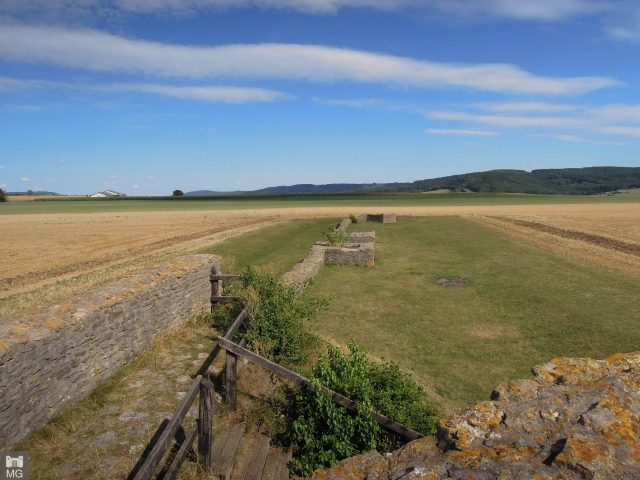
The Roman Castle can be visited
Roman Castle Sablonetum

The Ellingen fort, (Latin Sablonetum), is a former Roman fort that secured a section of the border fortifications near the Raetian Limes. The site, which is a UNESCO World Heritage Site, was built about 700 meters east of the town of Ellingen in the district of Weißenburg-Gunzenhausen in Bavaria. The site gained its particular importance through its extensive exploration using modern methods.
The Roman fortification is located on a plateau east of Ellingen, about 1.8 kilometers south of the Limes and almost four kilometers north of the next larger military base, Weißenburg-Biriciana. From the fort, it was not possible to directly view the lower-lying border fortifications in front of it. Visual contact only existed with Wp 14/33 to the northeast and with the northwestern towers at the Limes crossing on the Schwäbische Rezat. This topographically unfavorable location has not yet been explained.
Research History+
As the field name "In der Burg" (In the Castle), on which the camp stands, suggests, knowledge of an old fortified site was probably never completely lost. As early as 1895, the Ellingen fort was discovered and investigated by Wilhelm Kohl, a section commissioner of the Imperial Limes Commission (RLK). However, the excavations at that time yielded unsatisfactory results. The fort was not published separately by the RLK, but only as part of the route descriptions, so there is no ORL number.
It was not until 1980 to 1982, in the course of land consolidation, that comprehensive archaeological excavations were again carried out by the Bavarian State Office for Monument Preservation. During these excavations, almost the entire fort area and large parts of the adjacent Vicus were explored. Following the archaeological work, the fort was reconstructed in the area of the north front with gate and corner towers in such a way that the impression of a ruined Roman fortress was created.
Fort History+
The Ellingen fort was built in early Hadrianic times, probably around the year 120, as part of the final expansion of the Raetian Limes. An older construction phase, characterized by a timber-earth rampart, was followed around the year 182 under Commodus by a second expansion phase with a stone wall. Extensive reconstruction measures were also carried out inside the fort during this period. The reconstruction measures of 182, as well as the ancient name of the camp, are attested by a building inscription. Its content translates as:
:To Imperator Caesar Marcus Aurelius Commodus Antoninus Augustus, conqueror of the Germans, greatest conqueror of the Sarmatians, with tribunician power, consul for the 3rd time, father of the fatherland, the wall with the gates of Castellum Sablonetum were replaced with stones by order of Quintus Spicius Cerialis, the imperial legate with propraetorian power, under the consulate of Mamertinus and Rufus by the Singulares Pedites, under the leadership of Aurelius Argivus, centurion of the 3rd Italic Legion.
The Latin name Castellum Sablonetum can be roughly translated as "camp on the sand". The Raetian governor Quintus Spicius Cerialis, mentioned in this building inscription, had already had the previous timber-earth fort of Böhming in the Altmühltal converted into stone a year earlier, shortly after taking office, by a detachment of the 3rd Italic Legion (Legio III Italica) stationed in Regensburg.
The Ellingen fortification was probably abandoned in the Alamannic Wars no later than 233. The date 229, often mentioned in older publications, is rejected in more recent research. It was probably systematically cleared, as no fire and destruction horizons pointing in another direction could be detected.
Findings+
The two-gated fort, approximately 90 x 80 meters in size, was aligned with its main street axis (Via praetoria) in a north-south direction. In its last expansion phase, it was surrounded by a stone wall, whose rounded corners were fortified with simple towers and whose gates on the north and south fronts were fortified with double towers. A simple pointed ditch, averaging five to six meters wide and two meters deep, ran around the wall. In terms of building type and size, Castellum Sablonetum resembles the forts in Böhming and Halheim.
An earthen rampart served as a rampart walk and at the same time to stabilize the surrounding wall. Right-angled, gravel-paved roads with gravel surfacing subdivided the interior of the camp. The main road running between the north and south gates was interrupted by a structure. This is probably the remains of a staff building (Principia) of the fort, reduced to the flag sanctuary (Aedes). This truncated Principia gave rise to the consideration that the garrison of the fort might have been a Vexillatio (detachment) of a larger auxiliary troop, not operating independently, and not an independent Numerus. It is therefore quite possible that the Pedites singulares mentioned in the building inscription not only built the fort but also occupied it.
The interior buildings were largely constructed in half-timbered style. A large part of the eastern half of the camp was covered by a large building in which the troops were housed. This double barracks contained 24 Contubernia (room communities of eight men each). Two other buildings in the northwest and northeast of the camp are also referred to as possible troop barracks with ten additional Contubernia, so that the maximum occupancy of the Ellingen fort could have been over 260 men. These more recent research results have rendered older assumptions that the fort was occupied by two centuries of 80 men each obsolete. However, the assumption of an occupation with two infantry centuries reinforced by a cavalry detachment is also possible.
The buildings in the southern part probably represented Fabricae (workshops), the larger building in the southwest corner of the camp can possibly be referred to as the Praetorium (commander's residence). The massive wall foundations west of the Principia obviously belonged to a Horreum (granary). A Valetudinarium (hospital) can be assumed but could not be definitively proven. An adequate supply of drinking water was ensured by at least five or six wells.
East of the fort, as with every Roman military camp, a Vicus extended – a civilian settlement where soldiers' relatives, as well as merchants, craftsmen, and tavern and brothel operators, usually settled. A small fort bath was also located here. Furthermore, the ditch systems of other military installations in this area can be seen in aerial photographs. Among other things, the southwest corner of the double ditch system of a larger military installation is visible on Google Earth.
Take Mobile History with you
You are reading this text for free. Premium adds what matters on the road: descriptions read aloud, sites found through your camera, whole regions taken offline.
- Every description, including the ~17,700 Premium sites
- Audio guide: have descriptions read to you on location
- AR finder: see sites through your camera, with distance and bearing
- Unlimited saved sites
14 days free, then from €2.99 a month. Cancel anytime.
Source: Wikipedia · Licence: CC BY-SA 4.0 · Image: Mobile Geschichte
This description draws on the facts documented in the linked Wikipedia article; Wikipedia content is licensed under CC BY-SA 4.0. Wording and editing: Mobile History.
Location: 49.0642, 10.9880