Ancient BuildingEngelhartszell-Oberranna

Roman Castle Oberranna
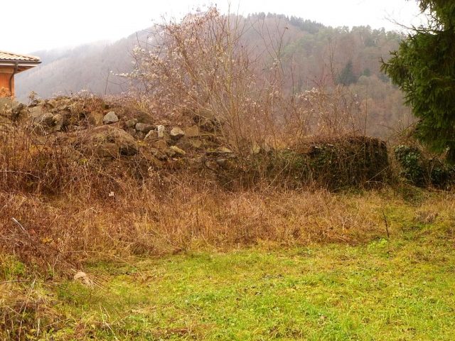
Roman Castle Oberranna

The remains of the roman Castle can be visited

The small fort of Oberranna, presumably identical with ancient Stanacum, is mostly regarded by researchers as a Roman auxiliary troop base (Burgus?) and part of the fortress chain of the Danubian Limes in the province of Noricum. It is located in the municipality of Engelhartszell, district of Oberranna, in the district of Schärding, Innviertel, federal state of Upper Austria.

The building – presumably dating from the middle Imperial period – was located directly on the Limes road. The interpretation as a fortification is doubtful; it is possible that the building remains were in fact the remains of a thermal bath complex. Nothing is known about the historical development and the garrison units of this base.

Location, Name and Function+

The site is located about eleven kilometers upstream from Schlögen, where the Danube valley widens again. The location of the small fort on the via iuxta Danuvium, which is now followed by Federal Highway 130, on the right bank of the Danube, allowed control of the opposite mouth of the Ranna and the river lowlands formed by low terraces (Hans Jüngling). Richard Trampler considered it to be the western flank protection of the small fort of Schlögen (Iovacum). An former guesthouse now stands over the northern part of the area.

The identification of this outpost as ancient Stanacum, which is only recorded in the Itinerarium Antonini (249, 4), a travel guide from the 3rd century, is not entirely certain but very probable. According to this directory, this road station was 20 miles (29.6 km) from Boiodurum (Passau) and 18 miles (26.7 km) from Iovacum (Schlögen). These distance specifications precisely match Oberranna. In the other two main ancient sources of the Danubian Limes, Notitia Dignitatum and Tabula Peutingeriana, the location is not mentioned.

Research History+

The site has been little investigated. In 1840, the wall remains were discovered by the Schlögen excavation society and uncovered between 1840 and 1842 under the direction of Josef Gaisberger (1792–1871). They were considered to be the southeast wall (with two round corner towers) of a small fort. The excavation process was not documented; only two contemporary pen-and-ink drawings of the south front with the two round structures at the corners exist. During subsequent excavations in 1842, further small finds such as "ceramic vessels, various metals, fragments of iron spurs, red earthenware, and wall cladding" were recovered. Hans Jüngling reported in 1953 on the discovery of a cellar, bricks, and ceramics (communication from Rudolf Fattinger). The finds were cataloged by Rudolf Noll in 1958.

In a hurried emergency excavation in 1960, occasioned by the widening of the federal highway, the southwestern outer wall between house Oberranna No. 5 and Federal Highway 130, running 13 m to the south, was again uncovered, corresponding to the course of the ancient Limes road. The east tower could not be investigated. During the removal of a terrain step by an excavator, a massive wall construction was encountered, which was partially destroyed or torn out in the process. The remaining parts of the approximately 1.6 m high standing masonry were examined and conserved by Lothar Eckhart (Upper Austrian State Museums), and in some places, further investigations were carried out. Ceramic vessels and bricks were secured as small finds.

The last excavation took place in 2005 on the initiative of the Federal Monuments Office (led by Andrzej Karbinski). The occasion was the construction of a new building on the neighboring property. The parcel surrounds parcel 135/1, which is a protected monument and the site of the small fort. A total of four test trenches were laid; in the western part of the property, a stone layer was found at a depth of 0.6 m, which was dated to the Middle Imperial period; furthermore, leveling layers were found at a depth of 0.4 m to 0.5 m, which contained fragments of Roman roof tiles (tegulae) and ceramics.

Findings and Dating+

The presumed multi-phase fortification here was oriented with its narrow side from NE to SW, had internal dimensions of 12.5 x 17 m, and was possibly provided with rounded defensive towers at three of its corners (NE, NW, SE), a so-called quadriburgium. The 9.75 m long SW wall was still preserved to a height of approx. 1.60 m and measured 1.50 m in the middle. It consisted of hot-mortared rubble stones. A mortar screed formed the inner floor. 0.85 m below, another layer of mortar was found, suggesting underfloor heating.

  • In the north, the area is overlaid by a modern building (former "Gasthof Wagner"), in whose cellar the remains of the tower located in the north corner have been preserved.
  • The south tower had a diameter of 4.80 m, the wall was 1.60 m wide, and the SE wall attached here was as strong as its southwestern counterpart.
  • The SW tower was considerably larger due to its use as a bathhouse and had been separated into two rooms by a 7.80 m long and 0.75 m wide wall.
  • The SE tower could not be investigated.

The corner towers suggest military use and were probably added in late antiquity. If this was indeed a fort or at least a burgus, then the defensive structure can best be compared with the – albeit considerably larger – Pannonian small fort of Visegrád–Gizellamajor, in whose NW tower a hot bath had also been installed.

According to Thomas Fischer (2002), however, these wall remains do not represent a fortress, but rather the thermal bath complex of a nearby fort. In his opinion, the tower in the southwest corner is an apse in which a small hot water basin (caldarium) with hypocaustum and hollow brick walls was installed; two wall projections of the praefurnium (heating room) attached to the south side were also partially preserved. The heating was supplied via a channel partially lined with bricks. The double floors were again 0.85 m apart. The unexamined northeast room was probably also adapted for bathing purposes. Both rooms were connected by a 1.5 m wide door. In the adjoining 1.5 m thick SW wall, a small, 1.5 m wide niche is recessed, which originally either housed an emperor or deity statue or served as a recess for laying hollow bricks (tubuli) that discharged the flue gases from the underfloor heating into a chimney. The SE corner tower, which could largely not be examined at all but was only added to the excavation plan based on assumptions, had a 1.50 m wide passage in the north, which presumably led to the main room (tepidarium?), and could also have served as an apse of a sweat bath (laconicum or sudatorium) due to the evidence of water-resistant mortar remains.

Beneath the current findings, the remains of an older, two-phase building could still be detected, whose dimensions and function, however, remained unclear. The sparse finds do not allow for a clear dating, but suggest use in the period before 300 AD. Due to the meager finds, nothing precise can be said about the time of the building's construction either. It was probably largely built or possibly modernized in late antiquity.

Milestone+

Of the numerous Roman milestones that are to be assumed for Upper Austria, only six known examples (Wels, Mösensdorf, Vöcklabruck, Weiterschwang near Gampern, Timmelkamm) have survived the centuries (Gerhard Winkler). One of them was found near the small fort, at Jochenstein. It could be dated to the reign of Emperor Caracalla and is now considered lost. Its inscription indicated Boiodurum (Passau) as the caput viae (Latin "head" = starting point). The name of the place 15 milia passum from Boiodurum was no longer identifiable (Saloato?). The phrase "...viam iuxta amnem Danuvium fieri iussit..." means that the road was not completely rebuilt at the beginning of the 3rd century, but this section was renovated in preparation for a campaign against the Alamanni (213 AD). From its starting point Boiodurum, this section of the Limes road ran via Stanacum to Ioviacum, Ad Mauros to Ovilavis (Wels). The inscription reads as follows, according to Gerhard Winkler:

Imp(erator) Caesar M(arcus) Aureliu/s Antoni- nus Pius Fe- lix Aug(ustus) Par- t(hicus) maximus Brit(annicus) maxim- us tr(ibunicia) p(otestate) X[V imp(erator) III co(n)s(ul) design(atus) IIII] viam iuxta amnem Da- nuvium fi- eri iussit a Boiioduru(!) in SALOATO m(ilia) p(assuum) XV

Translation: "Emperor Caesar Marcus Aurelius Antoninus, the pious and fortunate Augustus, greatest victor over the Parthians, greatest victor over the Britons, holding tribunician power for the 15th time, proclaimed Imperator three times, designated Consul for the fourth time, ordered a road to be built along the Danube, from Boiodurum to [...] 15 Roman miles."

Note+

Access is via Federal Highway 130 (Nibelungenstraße), the site is located at the eastern end of the village between the Danube bank and the federal highway. The preserved masonry still protrudes about 1.6 m from the ground.

Take Mobile History with you

You are reading this text for free. Premium adds what matters on the road: descriptions read aloud, sites found through your camera, whole regions taken offline.

  • Every description, including the ~17,700 Premium sites
  • Audio guide: have descriptions read to you on location
  • AR finder: see sites through your camera, with distance and bearing
  • Unlimited saved sites

14 days free, then from €2.99 a month. Cancel anytime.

Source: Wikipedia · Licence: CC BY-SA 4.0 · Image: http://commons.wikimedia.org/wiki/File:Oberranna_%28Burgus-3%29.JPG

This description draws on the facts documented in the linked Wikipedia article; Wikipedia content is licensed under CC BY-SA 4.0. Wording and editing: Mobile History.

Location: 48.4712, 13.7743