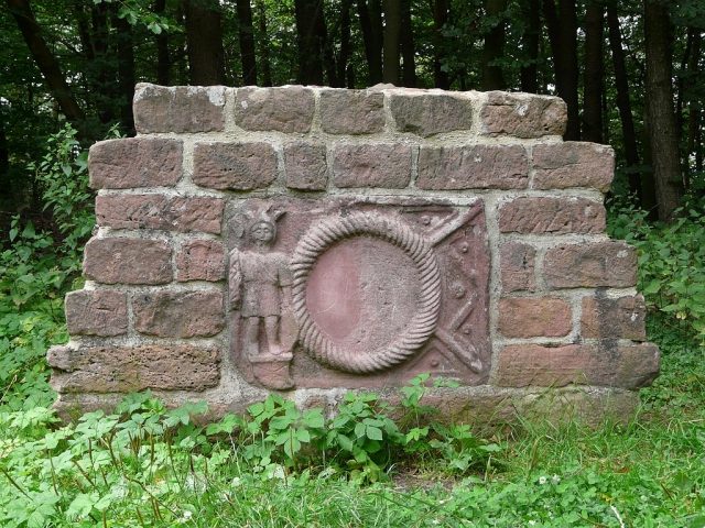
The remains of the roman Castle can be visited
Roman Castle Zwing

The small fort Zwing – also known as the small fort Jägerwiese – was a Roman border fort on the older Odenwald line of the Neckar-Odenwald Limes. The present-day archaeological monument is located on a mountain saddle almost two kilometers south of Hesselbach, a district of the municipality of Hesseneck in the Odenwaldkreis, directly on the district road from Hesselbach to Schloßau, a district of the municipality of Mudau in the Neckar-Odenwald-Kreis in Baden-Württemberg.
The small fort Zwing is situated on a mountain saddle (491.4 m above sea level) between the Hohe Langhälde (548.3 m above sea level) in the north and the Hohwald (552.8 m above sea level) in the south, where several forest clearings and paths meet the district roads K40 and K3919 leading from Hesselbach to Schloßau. In ancient times, its task at this location was probably to monitor a pass leading from the Eutergrund via the Höllenklinge into the Waldleininger Valley.
Due to stone robbery and the inadequate excavation methods of the antiquity-enthusiastic Count Franz I zu Erbach-Erbach (1754–1823), who had already had excavations carried out there by Johann Friedrich Knapp at the beginning of the 19th century, much had already been destroyed when the Imperial Limes Commission, under the local direction of Eduard Anthes, investigated the area in 1895.
Small Fort+
A stone fort with a maximum size of 20 × 20 m was identified, which may have had a single gate, possibly facing the Limes, on the northeast side. The corners of the fort were rounded with a radius of three meters. The wall thickness was 75 cm. No ditches could be found during the investigations of the Imperial Limes Commission; the ditches observed during earlier research were probably created by the removal of the defensive walls.
Today, nothing of the fort is visible except for a Roman relief, of which a copy has been embedded in a modern wall. The original is located in the Badisches Landesmuseum in Karlsruhe. The 78 cm by 61 cm slab is dominated in its center by a 36.5 cm diameter circular area, which presumably originally contained a painted inscription. To the left is the figure of a warrior. Further finds from the small fort, including two smaller relief plates, each depicting a vexillum, are exhibited in the Heimatmuseum Amorbach.
Course of the Limes between the Small Forts Zwing and Seitzenbuche+
Starting at the small fort Zwing, the Limes leaves its previous north-south course and takes an east-southeast direction in a wide arc extending to Wp 10/35, which it maintains almost linearly until the small fort Seitzenbuche. The course of the Limes leads exclusively through densely wooded areas, which explains the good state of preservation of the Roman relics. From the small fort Zwing, with its approximately 491 meters of altitude, the Limes initially rises again by over 60 meters to Wp 10/34 (553 m above sea level), only to then continuously drop to 462 meters of altitude at the small fort Seitzenbuche.
Limes Wall
Approximately 150 m south of the small fort Zwing are the remains of a rather unusual section of the Odenwald Limes. For a length of 112 m, the Limes was not constructed as a palisade, but as a wall of Bunter sandstone. The reason was probably the difficulty of digging the palisade ditch in rocky ground, while stones were abundant there, at the highest point of the Odenwald Limes. The wall has a width of 0.9 m and was topped with rounded sandstone blocks. On the "Roman" side, the stones are neatly finished, while on the side facing away from the empire, they are only roughly hewn.
Take Mobile History with you
You are reading this text for free. Premium adds what matters on the road: descriptions read aloud, sites found through your camera, whole regions taken offline.
- Every description, including the ~17,700 Premium sites
- Audio guide: have descriptions read to you on location
- AR finder: see sites through your camera, with distance and bearing
- Unlimited saved sites
14 days free, then from €2.99 a month. Cancel anytime.
Source: Wikipedia · Licence: CC BY-SA 4.0 · Image: http://de.wikipedia.org/wiki/Datei:KK_Zwing.jpg
This description draws on the facts documented in the linked Wikipedia article; Wikipedia content is licensed under CC BY-SA 4.0. Wording and editing: Mobile History.
Location: 49.5610, 9.1010