RuinBockelnhagen

Allerburg Castle (Ruin) (Bockelnhagen)
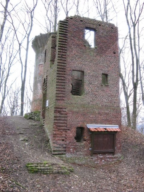
Allerburg Castle (Ruin) (Bockelnhagen)

Memorial, The remains of the Castle can be visited.

Allerburg Castle, also known as Ellerburg, is a castle ruin on the Allerberg mountain, near Bockelnhagen in the Eichsfeld district in Thuringia.

Location
The castle complex is located only about 3 km from the Thuringian-Lower Saxon state border near Bad Lauterberg and about 1200 m southwest of the village of Bockelnhagen on an isolated mountain cone south above the valley of the Weilroder Eller. The neighboring villages of Silkerode and Zwinge also lie at the foot of the castle.

History
The hilltop castle was probably built by the Lords of Allerberg as early as the 12th century. In 1266, the castle was first mentioned in a document as the ancestral seat of the Minningerode family, which belonged to the South Harz County of Lutterberg-Scharzfeld. In the 14th century, the castle was expanded and, after years of inheritance disputes, largely came into the possession of the Counts of Schwarzburg. During the Peasants' War in 1525, the castle was destroyed by rebels and was still mentioned as a ruin in 1596. In 1593, after the partial owners died out, the castle was completely taken over by the Counts of Schwarzburg and in 1612, through occupation, came into the possession of the Dukes of Brunswick, whose ownership was judicially confirmed in 1694. Through the Congress of Vienna, the castle passed to Prussia in 1816.

Carl Duval's Castle Description
On October 25, 1845, the Eichsfeld local historian and writer Carl Duval visited the castle complex; he also made the accompanying drawing for the following description.

Soon the mountain, which bears the Allerburg, lay before me, and the only masonry that still crowns the summit of the mountain, brightly illuminated by the sun, looked over the tall forest trees like a greeting from ancient times into the valley.

On a very pleasant, grassy path, where here and there seats are placed, I ascended the castle hill under green, yellow, and red colored trees and soon reached an open space, which in earlier times was built up, but is now veiled by fresh grass and frequently serves as a gathering place for cheerful companies from the surrounding area, especially from the nearby village of Bockelnhagen.

Several paths lead from this spot to the highest summit of the mountain. One first encounters a depression, which, according to the accounts of the locals, is said to originate from a buried cellar, or, according to others, from the fact that a treasure was once found here and excavations were carried out in the hope of discovering more, but these probably remained unsuccessful.

On the highest, steep peak of the mountain lies the masonry, which can be seen towering above the forest from a distance. It is not particularly distinguished by grandeur or picturesque beauty, but it is of particular interest as the last remains of a fortress that was inhabited by a family that is still cheerfully green and flourishing today.

Due to the small surface area of the mountain, the castle cannot have been of wide extent; but it can still be clearly recognized that it consisted of two parts, a lower and an upper castle, the latter, in the manner of the oldest fortresses, containing only a tower or a solid tower-like building. - Here too, on the higher points of the mountain, there are benches here and there.

Castle District
According to Duval and the deserted village inventory of Levin von Wintzingeroda-Knorr, the following localities belonged to the castle: Bockelnhagen, Silkerode, Zwinge and the Neue Hof, furthermore the deserted villages: Ankerode, Kirchdorf, Müncherode, Hochstedt, Besselhagen, Weilrode.

Observation Tower and Hermitage 
On the remains of the castle, an observation tower made of bricks with an attached hermitage was built around 1910 and 1930. This complex has also fallen into ruin; between 1945 and 1989, it was located in the 5-km restricted zone along the Inner German Border and thus could no longer be visited by the population.

Current Use
The castle site is a protected archaeological monument. The relevant area is used for forestry and is freely accessible to tourists.

Layout
The small castle complex extended over the leveled summit plateau of the mountain. The curtain wall, still recognizable in its extent and location, enclosed a castle area measuring approximately 25 by 35 meters, which was still surrounded by a circumferential rampart and moat. A stump of the former keep, with a diameter of 10 meters, is still preserved. Other wall remains are interpreted according to tradition as the ruin of the former parish church of St. Michael; it presumably served as the final resting place of the former lords of the castle.

The medieval complex, built of quarry stones, was supplemented by the construction of an observation tower made of bricks in the 1930s.

Take Mobile History with you

You are reading this text for free. Premium adds what matters on the road: descriptions read aloud, sites found through your camera, whole regions taken offline.

  • Every description, including the ~17,700 Premium sites
  • Audio guide: have descriptions read to you on location
  • AR finder: see sites through your camera, with distance and bearing
  • Unlimited saved sites

14 days free, then from €2.99 a month. Cancel anytime.

Source: Wikipedia · Licence: CC BY-SA 4.0

This description draws on the facts documented in the linked Wikipedia article; Wikipedia content is licensed under CC BY-SA 4.0. Wording and editing: Mobile History.

Location: 51.5541, 10.4157