RuinBechthal

Bechthal Castle (Ruin)

Bechthal Castle (Ruin)

The remains of the Castle can be visited

The ruin of Bechthal Castle is located about 500 meters southeast of the Raitenbuch district of Bechthal on a ridge above the Anlautertal valley in the Weißenburg-Gunzenhausen district in Middle Franconia. Remains of walls and the slender keep have been preserved from the High to Late Medieval fortified complex.

The ridge above the Anlautertal valley served as a partially fortified settlement site during the Urnfield, Hallstatt, La Tène, and Migration periods.

The High Medieval spur castle is the ancestral seat of the Lords of Pechthal (Bechthal), who first appear in written sources in the mid-12th century. The family name could be related to earlier pitch production in this area. In the sparse literature, the castle lords are referred to as ministeriales of the Prince-Bishopric of Eichstätt.

Subsequently, the Pechthalers were apparently able to free themselves from dependence on the Prince-Bishopric and establish a small independent lordship in the surrounding area.

In 1353, Konrad der Pechthaler had to transfer half of his own fortress to Konrad von Heideck and received the property back as a fief. In 1414, Hermann Pechthaler sold the lordship to Rüdiger von Erlingshofen. In 1473, Sigmund and Caspar Erlingshofer are mentioned as co-owners. In 1503, the brothers Christoph and Albrecht Reicharter were co-owners of the castle. In 1544 and 1557, the Prince-Bishopric of Eichstätt acquired both halves of the castle.

After the transfer of ownership to the Prince-Bishopric, the fortress seems to have become dispensable. The place was administered by the episcopal Pflegamt (bailiwick) of Titting or Raitenbuch. The exact reasons for the abandonment of the castle are unknown. Nuremberg chroniclers report a final destruction by Swedish artillery during the Thirty Years' War (1633).

In the 19th century, the castle was referred to as "Burg Waldeck". This unhistorical name is probably due to its romantic location on a "wooded corner". In the years 1983/84, the ruin was secured by a renovation.

Description+

The High Medieval castle is located within an older section fortification. The elongated ridge is secured by a total of five transverse ditches, whose exact dating is unclear.

East of the partially preserved main castle, two spacious outer bailey plateaus extend. The end of the terrain spur is surrounded by a rubble stone wall preserved as a foundation. Approximately 55 meters in front of the deep eastern neck ditch of the core castle, a roughly three-meter-high rampart ditch is visible. The rampart goes back to a largely collapsed limestone wall. Further wall remains can be made out on the outer bailey plateau.

The eastern neck ditch is largely carved out of the rock and up to 10 meters deep. The approximately square main castle mound (approx. 30 × 35 meters) behind it is surrounded in the south and west by a shallow, angular inner ditch, which continues to the north as a terrace. The earth removed for this purpose was piled up on the slope to form two mighty slope terraces.

To the west, a narrow rock reef is situated in front of the main castle, in front of which another section ditch was laid out. After about 40 meters, the rugged foreland is again cut through by a shallow transverse ditch.

The Main Castle

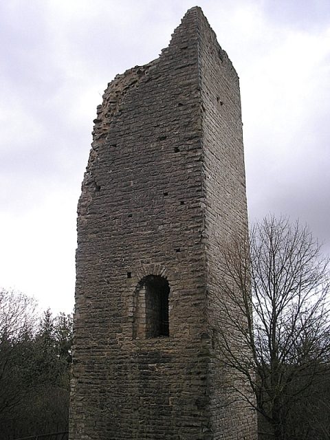
The masonry of the relatively small core castle was largely removed and reused. The best-preserved part is the square, approximately 30-meter-high keep with a side length of 5.5 meters and a wall thickness of 1.5 meters. The tower consists of smaller, ashlar-like dressed limestone rubble stones of local origin. On the west side, the obligatory high entrance leads into the interior with its vaulted second upper floor.

Only foundation remains and rubble walls on the castle plateau bear witness to the other interior buildings. The residential building was probably located in the northwest in front of the keep. Above the southwest corner rises the striking ruin of a narrow rectangular tower with some light openings.

On the south side of the castle, large parts of the infill of the former outer wall are still visible. In some places, the outer shell of rubble stones is preserved here.

The Bavarian State Office for Monument Preservation lists the castle site as a settlement of the Urnfield, Hallstatt, La Tène, and Migration periods, as well as a medieval castle site with subterranean components of the castle ruin "Waldeck" under monument number D-5-6933-0316.

Take Mobile History with you

You are reading this text for free. Premium adds what matters on the road: descriptions read aloud, sites found through your camera, whole regions taken offline.

  • Every description, including the ~17,700 Premium sites
  • Audio guide: have descriptions read to you on location
  • AR finder: see sites through your camera, with distance and bearing
  • Unlimited saved sites

14 days free, then from €2.99 a month. Cancel anytime.

Source: Wikipedia · Licence: CC BY-SA 4.0

This description draws on the facts documented in the linked Wikipedia article; Wikipedia content is licensed under CC BY-SA 4.0. Wording and editing: Mobile History.

Location: 49.0205, 11.1782