RuinBocksberg

Bocksberg Castle (Ruin)

Bocksberg Castle (Ruin)

The remains of the Castle can be visited

The ruin of Bocksberg Castle is located south on a hill above the Laugna district of Bocksberg in the Dillingen an der Donau district (Swabia). From the high to late medieval castle complex, moats and earthworks and a remnant of the keep have been preserved.

The hilltop castle probably originated in the early 13th century as the seat of the Lords of Bocksberg, who are documented here from 1231 to 1322. The probably noble family is likely to have died out in the 14th century.

Subsequently, the Marschalken von Bocksberg appear as vassals of the Prince-Bishopric of Augsburg at the fortress. In 1378, the castle was damaged during a warlike conflict. The following year (1379), the Augsburg patrician family Rehm acquired the lordship.

In 1462, Andreas Rieter von Kornburg (also: Rieder) from Nuremberg married into the family. In this year, the castle was destroyed again in the "Second City War". In 1542, the entire property went to the Lords of Stetten. In 1613, a Schertlin von Burtenbach bought the lordship and sold it in the same year, together with Emersacker and Laugna, to the Fuggers of Augsburg. During the Thirty Years' War, the complex was so severely damaged that reconstruction was abandoned. From 1660, the Fugger family foundation administered the properties. Bocksberg was now administered from Laugna.

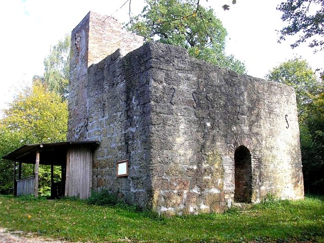
After the Second World War, the castle area was converted into a festival ground and electrified. The high medieval keep was renovated, but is surrounded by wooden extensions for festival operations.

Description+

The castle is located above the village on a wooded ridge of the Laugna valley. The stepped conical peak of the main castle is cut off from the hinterland by a deep, arched neck ditch. To the north, the natural steep slope secures the fortress.

North and east of the main castle cone, a spacious lower terrace held the former outer bailey. The area has long served as a festival ground and is now leveled and occupied by numerous wooden stalls and a stage. Some stalls were also erected in the neck ditch, the access is marked by a high wooden palisade.

On the plateau of the main castle, the stump of the former residential tower or keep is still preserved. The square masonry of smooth Nagelfluh ashlar has an edge length of approx. 9.25 meters. The wall thicknesses are about 1.75 meters. At the northeast corner, the tower is still approximately eight meters high, the upper parts consist of renovated brickwork.

A small view on a map from the second half of the 16th century shows two castle houses with gabled roofs. The mighty keep has a pointed helmet with small defensive oriels.

Only about 200 meters south of the castle ruin lies a large high medieval motte (Buschelberg) on the slope, which either marks an older predecessor castle or may have served as the seat of one of the vassals of the first castle lords. The castle site already appears on the aforementioned map with the view of the castle.

Take Mobile History with you

You are reading this text for free. Premium adds what matters on the road: descriptions read aloud, sites found through your camera, whole regions taken offline.

  • Every description, including the ~17,700 Premium sites
  • Audio guide: have descriptions read to you on location
  • AR finder: see sites through your camera, with distance and bearing
  • Unlimited saved sites

14 days free, then from €2.99 a month. Cancel anytime.

Source: Wikipedia · Licence: CC BY-SA 4.0

This description draws on the facts documented in the linked Wikipedia article; Wikipedia content is licensed under CC BY-SA 4.0. Wording and editing: Mobile History.

Location: 48.5089, 10.6840