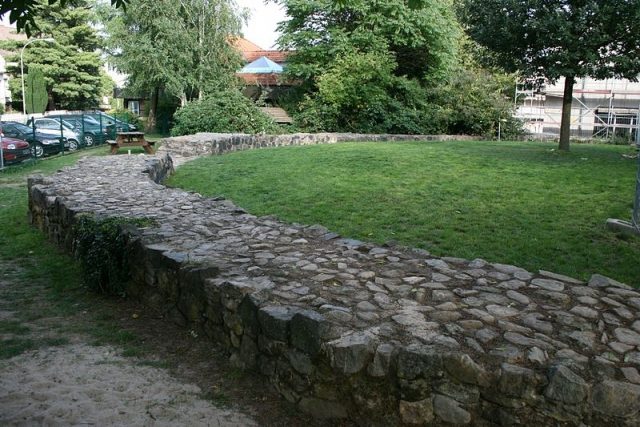
The remains of the Castle can be visited
Bommersheim Castle (Ruin)

Bommersheim Castle is a former castle complex in the Bommersheim district of the city of Oberursel in the Hochtaunuskreis in Hesse, whose foundation remains have been partially uncovered since 1988.
The former castle was located behind the current church of St. Aureus and Justina on Im Himmrich street, between Lange Straße and Burgstraße, on the eastern edge of Bommersheim. It lay on the edge of the Kalbach depression, near where the Saalburgstraße intersected with the Weinstraße, a pre-Roman trade route that may have continued to be used in the Middle Ages.
The origins of the castle date back to a so-called motte, which, according to the findings, was probably built in the 11th or 12th century by the Lords of Bommersheim. The village of Bommersheim seems to have already existed at this time; its first mention in the Lorsch Codex dates back to 792.
By the 13th century, the motte-and-bailey castle had become too small, and a lowland castle with a stone ring wall was built in its place. The reason for the reconstruction was probably a change of ownership, as the castle subsequently appears as a Ganerbenburg (jointly inherited castle) and no longer as the noble seat of a single family.
Towards the end of the 14th century, the Imperial City of Frankfurt increasingly came into conflict with the surrounding nobles, some of whom formed the Löwenbund (Lion's League), while Frankfurt joined the Rhenish League of Cities. The background was the increasing impoverishment of the lower nobility, whose members were tempted to raid merchants and traders on their way to Frankfurt (so-called robber knighthood). The brothers Ruprecht and Wolf von Bommersheim, as well as the other co-heir Udo von Vilmar, had also participated in this. On January 29, 1382, Frankfurt declared a feud against the inhabitants of the castle and apparently acted quickly: already on March 9, complaints from the Bommersheim knights about the destruction of the castle arrived in Frankfurt, narrowing the time of the hostilities to February of that year. Efforts by the Lords of Cronberg to organize a relief of the castle by the Archbishop of Mainz were unsuccessful.
In the course of this punitive action, other castles in the area were also attacked by the Rhenish League of Cities. Previously, the Schelmenburg in Bergen-Enkheim had been taken without a fight, and Eppstein Castle in Schotten, jointly owned by Johann von Rodenstein and some Schenken zu Schweinsberg, had been destroyed. Bommersheim Castle was not rebuilt. The co-heirs involved unsuccessfully disputed compensation before the Imperial Court well into the 15th century, until the process was finally dropped.
Towards the end of the 19th century, part of the area was leveled to create a fairground, causing its exact location to be forgotten. When a fire pond was excavated in 1941, its walls were cut into and examined by Ferdinand Kutsch. Subsequently, during sewer work, wall remains were repeatedly encountered, including in 1988, when the discovery, thanks to the increased historical awareness of some citizens and the city council, led to an archaeological investigation lasting several years. Today, part of the ring wall foundations, built up to a height of 0.50 – 0.70 m, is integrated into the outdoor area of a children's day care center.
Layout+
All information about the layout and construction history comes from archaeological excavations of the last two decades. Due to modern disturbances and later overbuilding, these findings were quite fragmentary, but they provide a vivid picture of the history of the small noble residence.
Motte-and-Bailey Castle
According to the excavation findings, the oldest parts of the castle consist of the motte of a so-called motte-and-bailey castle, which had a diameter of 20 to 25 meters at its base. This would leave a space of about 10 meters in diameter on the hill plateau, where a wooden residential tower was located. The height is estimated to be between 2.5 and 4 meters. The motte was secured externally by a wooden palisade or a wattle fence. Finds of sharpened wooden stakes, driven into the ground at a distance of 15 – 20 cm, allow both interpretations. In addition, a ditch 1.8 m deep and 4 m wide was found. Probably there was another ditch in front of it, but its findings are less certain.
The rough dating of the complex to the 11th/12th century was mainly based on the find of a painted Pingsdorf-style pottery shard with a handle.
Lowland Castle
With the conversion to a ring wall castle, a 1.70 m thick ring wall was erected in place of the outer rampart, and the interior was filled up. The masonry was executed in two-shell technique. The castle buildings were leaned against this wall on the inside in the form of a perimeter development, probably with the eaves facing outwards, which is supported by the numerous finds from the castle moat. The polygonal wall course with obtuse-angled corners had a diameter of 35 m and enclosed an area of about 1000 m². Outside the current reconstruction, it extends southwest into the cemetery of the Church of St. Aureus and Justina. The interior was filled with modern rubble, and no visible masonry of the walls remained. The walking level of the castle courtyard has thus eroded, and statements about the interior development were not possible from the archaeological findings.
Around the ring wall ran a ditch more than 9 m wide and about 2 m deep. The earliest ceramic finds from this ditch date to the first half of the 13th century. The building type of the lowland castle strongly resembles the nearby Bonames Castle, which was built at the same time.
Finds+
Due to the preservation in wet soil, abundant find material could be recovered, especially in the castle moat. Because of the destruction of the castle, the later finds are particularly numerous and represent the inventory of the castle at this precisely determinable time. Thus, in the wet soil, an almost complete castle house inventory with medieval ceramics (primarily utilitarian pottery such as pots, jugs, and tiles, but also glass knobbed beakers are attested) from the 13th to 14th centuries, as well as carefully carved door and window cornices made of red Main sandstone, have been found. The eating habits of the castle inhabitants can be reconstructed by examining the found plant remains and animal bones.
Metal objects are present in the form of knives and spoons, keys, iron fittings, jaw harps, and arrowheads. The showpiece of this group of finds is an iron jousting lance tip in the shape of a crown. From the clothing of the castle inhabitants, mainly leather parts have been preserved (parts of doublets, remains of jackets and belts, and shoes). Also frequently associated with clothing are fittings, buckles and clasps, needles, gold wires, and pearl necklaces made of amber and rock crystal.
Cast pilgrim badges and scallop shells, which probably indicate journeys to Santiago de Compostela, bear witness to the inhabitants' pilgrimages.
The destruction of the castle is evidenced by crossbow bolts and basalt cannonballs.
Numerous finds from the excavations are exhibited in the Vortaunusmuseum Oberursel.
Take Mobile History with you
You are reading this text for free. Premium adds what matters on the road: descriptions read aloud, sites found through your camera, whole regions taken offline.
- Every description, including the ~17,700 Premium sites
- Audio guide: have descriptions read to you on location
- AR finder: see sites through your camera, with distance and bearing
- Unlimited saved sites
14 days free, then from €2.99 a month. Cancel anytime.
Source: Wikipedia · Licence: CC BY-SA 4.0
This description draws on the facts documented in the linked Wikipedia article; Wikipedia content is licensed under CC BY-SA 4.0. Wording and editing: Mobile History.
Location: 50.1991, 8.6022