CastleSils im Domleschg

Campell Castle (Ruin) (Sils im Domleschg)
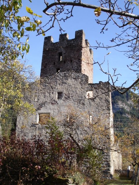
Campell Castle (Ruin) (Sils im Domleschg)

The remains of the Castle can be visited

The ruin of Campell, also called Campì, is a ruin in the municipality of Sils im Domleschg in the Swiss canton of Graubünden. The name camp bel means beautiful field.

Location+

The ruin is located southeast of the village on a rocky outcrop above the Albula at the end of the Schin Gorge, on the edge of a small terrain terrace where the castle estates used to be.

Construction History+

The current appearance of the complex is shaped by the last extensive renovations from the 16th and 17th centuries. The original building fabric has been preserved mainly in the tower and the east wing. A building history investigation carried out by the cantonal monument preservation revealed an exemplary building sequence in five phases – from the fortified tower of the 13th century to the castle complex of 1635.

1st Construction Phase (13th Century)

The beginnings of the castle are to be found in a fortified residential tower with four floors. Access was via a high entrance on the east side on the third floor. On the north wall were two latrine oriels. At the eastern end of the castle plateau stood a second building, which had been built of stone. However, only a small part of its wall remains, which was built over in the second phase.

2nd Construction Phase (13th or early 14th Century)

The entire plateau was built over to its outermost edge, thus significantly enlarging the complex. It received a curtain wall with a gate, a deepened moat with a drawbridge on the western attack side, and an outer bailey with a battlement and merlons with swallowtail battlements. On the east side was a courtyard with access to the two floors of the residential wing. On the ground floor of this building was a large kitchen with a fireplace and two sinks.

3rd Construction Phase (15th Century)

The tower was raised by two floors and provided with an internal lean-to roof. On the fifth floor, to the west, was a covered loggia. In the northern part of the outer bailey, a tower-like two-story building was erected. A new cistern was built on the north slope to collect rainwater from the roof.

4th Construction Phase (16th Century)

The complex developed from a castle to a palace. In place of the outer bailey, a three-story palas was built, with swallowtail battlements, an internal gable roof, and loggias on the third floor to the south. Access to the complex was moved further south and was accessible via a ramp. The opening of the former castle gate was walled up. A newly erected traverse wall at the northeast corner of the complex henceforth formed an additional obstacle for potential attackers. At the beginning of the 17th century, the complex was destroyed by fire, presumably in connection with the Bündner Wirren during the Thirty Years' War.

5th Construction Phase (1635)

The palas was rebuilt. The ridge of the roof was oriented to the west, and the battlements of the 4th phase were walled up. On the 2nd floor, a paneled room was installed and a latrine oriel next to the bedroom. The two lower floors of the tower were converted as access to the palas, and the high entrance was moved to the 2nd floor. The east wing remained a ruin and was used as a stable.

Written information about the builders is missing, but it is likely to have been the Lords of Campell, who established the center of a small clearing lordship here. In 1289, an income register of the Diocese of Chur mentions an Egeno de Campell, who had to pay fifteen shillings annually to the church of Hohenrätien. The family was initially free but then fell into dependence on the Bishop of Chur and became his ministerials.

The Knights of Campell probably died out in the 14th century. There is no evidence for the assumption that the family was driven out in a feud with the Barons of Rhäzüns, just as there is no evidence for the conjecture that the Engadine family Campell is directly descended from the noble knightly family.

A note in the property register of the Diocese of Chur from 1389 indicates that Bishop Hartmann had granted estates to Hans and Gottfried von Ehrenfels, which had previously been fiefs of the Lords of Campell. However, the castle itself was probably not yet in episcopal hands at that time, as it is not mentioned in the "Buoch der Vestinen" of 1410. This must have changed shortly thereafter, however, because in 1418 the Bishop granted Campell to Hermann von Schauenstein-Ehrenfels.

In the second half of the 15th century, a branch of the Rink (or Ringg) family resided in the castle. In 1457, a Junker Taniell Ring von Gampell is mentioned for the first time; he probably came into possession of the episcopal fief through his mother Adelheid von Schauenstein. The Rinks resided in the castle at least until 1493, then it reverted to the Schauenstein-Ehrenfels. In 1562, Rudolf von Ehrenfels sold Campell Castle with its estates and tithes to his cousin Gilly von Ehrenfels.

In 1567, the Grisons Landeshauptmann Hercules von Salis zu Rietberg acquired it. Through inheritance, Campell passed in equal halves to the sons Andreas and Anton von Salis-Rietberg. Captain Andreas von Salis (1563-1635) of and to Neuensins and Aspermont and his wife Margaretha Carlin von Hohenbalken gifted their half of the castle, the western part, to their son Andreas von Salis-Rietberg in 1634. Andreas married Maria Magdalena von Salis-Soglio, the daughter of Nikolaus von Salis-Soglio, in 1635. His initials NVS were carved into the still wet plaster along with the year after the last reconstruction.

Around 1700, the castle was already uninhabited but was still in good condition. In the following decades, the slow decay began, and around 1900, the Albula line of the Rhaetian Railway was built through the outer moat. In 1932, the Engadine family Campell acquired the castle and bequeathed it to the Ruine Campell/Campi Foundation in 1987. Since then, the foundation has been committed to the research and preservation of this remarkable complex. From 1991 to 1998, the ruin was investigated in terms of its building history, and the masonry was conserved.

The complex is under the protection of the Swiss Confederation and has been publicly accessible again since 2001.

Take Mobile History with you

You are reading this text for free. Premium adds what matters on the road: descriptions read aloud, sites found through your camera, whole regions taken offline.

  • Every description, including the ~17,700 Premium sites
  • Audio guide: have descriptions read to you on location
  • AR finder: see sites through your camera, with distance and bearing
  • Unlimited saved sites

14 days free, then from €2.99 a month. Cancel anytime.

Source: Wikipedia · Licence: CC BY-SA 4.0

This description draws on the facts documented in the linked Wikipedia article; Wikipedia content is licensed under CC BY-SA 4.0. Wording and editing: Mobile History.

Location: 46.7006, 9.4714