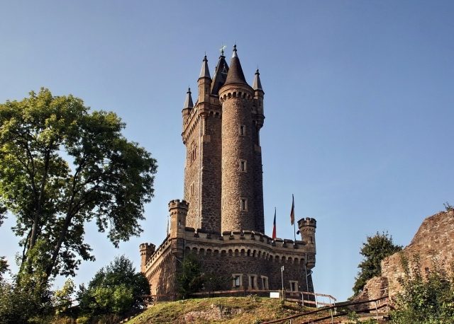
The remains of the Castle can be visited
Dillenburg Castle (Ruin)

Dillenburg Castle, which was expanded into a modern fortress (Fixed Castle) from the 1520s onwards, was the main residence of the Counts of Nassau-Dillenburg. The residential and economic buildings in particular were destroyed in 1760 during the Seven Years' War, and in 1768 the fortifications above ground were razed. Parts of the 16th-century casemates are preserved. From 1872–1875, the Wilhelmsturm was built on the former upper castle courtyard according to plans by master builder Friedrich Albert Cremer.
The predecessor of Dillenburg Castle was a castle complex of the Counts of Nassau from the 12th century. According to excavations, especially in the 1950s, it had an approximately circular curtain wall of about 30 meters in diameter, inside which stood a free-standing tower with sides measuring 8x7.30 meters. It was probably a residential tower with half-timbered floors on a stone base, as remains of wattle and daub and stove tiles were found in its fire debris. This first castle was destroyed in the Dernbach Feud around 1325/27.
Around the middle of the 15th century, the old castle was rebuilt and expanded. Above all, it was now to be defensible against increasingly effective firearms. In the years 1458–1462, a roundel with a semicircular plan was under construction on the south side, which was initially intended as an advanced, independent work to secure the moat on both sides with smaller firearms. Until the 17th century, a half-timbered superstructure rose above a brick floor with loopholes, sunk into the moat. The Dillenburg artillery roundel is a very early example of this type of construction.
In 1463/69, a zwinger was mentioned, i.e., a strip of land in front of the main wall, secured by a lower outer wall; it would have extended on the south and southeast sides and was later replaced by the large moat and the casemates. In 1463/64, a first Büchsenhaus (armory) was also mentioned.
Since the second half of the 15th century, Dillenburg became the constantly inhabited main residence of the Counts of Nassau from the Ottonian line. Presumably, the residential buildings and the castle chapel were also renewed at that time, but precise information is lacking. The complex was certainly already divided into an upper courtyard on the hilltop and the lower courtyard located to the south and southeast, where later the stables, forge, and the new armory were located.
In the decades after 1500, the political situation, especially with the neighboring Landgraviate of Hesse, was tense. Count Wilhelm the Rich of Nassau (reigned 1519 to 1559), in view of these threats, began to expand his residence with great effort into a modern fortress. In larger territories, such tasks were to be taken over by specialized state fortresses, such as Ziegenhain and Giessen in Hesse; in the small county, the transitional form of the Fixed Castle was chosen, which also had to continue to serve as the residence of the ruling family.
First, around 1524, the "gros thurn zu Dillenbergk vor der kuchen" was demolished, as it could have damaged the buildings if it collapsed under artillery fire. Under the master builder Ulrich (Utz) von Ansbach, who was also active in the metropolis of Nuremberg, the so-called Hohe Mauer (High Wall) on the city side was erected from 1523 to 1536, costing almost 200,000 guilders. On the main attack side in the south, high retaining walls with earth infill, capable of withstanding cannon fire, were also built on both sides of the older roundel. Here, the structure had (still preserved) casemate passages with loopholes for small arms for moat defense at its base, while the heavy guns stood on an (later removed) upper platform. Thanks to the main moat in front, only the upper part of the wall could be fired upon by the enemy, while the casemates with the loopholes were in a dead angle. In connection with the new walls and ramparts, two further strongholds were built, now presumably based on the new Italian invention of the bastion with a polygonal plan: the so-called Jägergemach in the west and the Junkerngemach in the east, both of which had extensive casemates. All these facilities were described in a poem in 1559 by the Dillenburg official Gottfried Hatzfeld.
Inside the castle, a new Buchsenhaus (armory) was built in 1547 on the west side of the lower courtyard. Since 1553, the New Building, which contained a large hall, supplemented the older buildings in the inner castle courtyard.
On a view of the Fixed Castle Dillenburg drawn around 1575, later published by Braun and Hogenberg in 1617, the complex can be seen in its completed state. A drawing by Wilhelm Dilich from 1605 also gives a good impression.
During the Thirty Years' War, the castle was able to withstand a siege due to its strong defenses.
The end of the fortress came in the Seven Years' War; after a 14-day siege by the French, it was shelled in July 1760, and most of the residential buildings burned down. In 1768, the fortifications were also razed by demolishing most of the above-ground structures and filling the casemates. Significant parts of the casemates were excavated in 1930–1934 and 1967/68 and are now partially accessible again.
Former Furnishings+
Although almost all of the castle's furnishings were destroyed in the fire of 1760, many details are preserved in older sources. An inventory of the castle from 1613 provides the most detailed report on the individual rooms and their furnishings at that time. These included numerous valuable tapestries, among them the famous eight wall hangings depicting the lineage of the House of Nassau, woven in Brussels in 1531. The lineage was a gift from Count Heinrich of Nassau-Breda to his brother Count Wilhelm the Rich of Nassau-Dillenburg. While the carpets themselves have been lost since the late 17th century, the original cartoons by the Dutch painter Bernard van Orley are still preserved.
Take Mobile History with you
You are reading this text for free. Premium adds what matters on the road: descriptions read aloud, sites found through your camera, whole regions taken offline.
- Every description, including the ~17,700 Premium sites
- Audio guide: have descriptions read to you on location
- AR finder: see sites through your camera, with distance and bearing
- Unlimited saved sites
14 days free, then from €2.99 a month. Cancel anytime.
Source: Wikipedia · Licence: CC BY-SA 4.0
This description draws on the facts documented in the linked Wikipedia article; Wikipedia content is licensed under CC BY-SA 4.0. Wording and editing: Mobile History.
Location: 50.7382, 8.2854