RuinGerolstein

Geroldstein Castle (Ruin)

Geroldstein Castle (Ruin)

The remains of the Castle can be visited

Geroldstein Castle is a castle ruin near Geroldstein, a district of Heidenrod, in the Rheingau-Taunus-Kreis.

The hilltop castle is located on a rock outcrop south of the village, close to the Wisper river. Originally, it was located north of the small river, but due to the construction of an ironworks, the river was straightened in 1589, so that it is now located south. To the west, uphill, is Haneck Castle.

There is almost no information available about the origins of Geroldstein Castle. Of the two Geroldstein castles, it is the older one, and its name probably derives from a nobleman named Gerhart, as it was first mentioned around 1215 as Gerhartstein. The Geroldstein family acted as vassals of the Counts of Katzenelnbogen and were able to establish a small lordship around the town of Geroldstein. In 1353, the castle was unsuccessfully besieged by troops of the Elector of Trier. In 1479, it fell to the Landgraviate of Hesse along with the County of Katzenelnbogen.

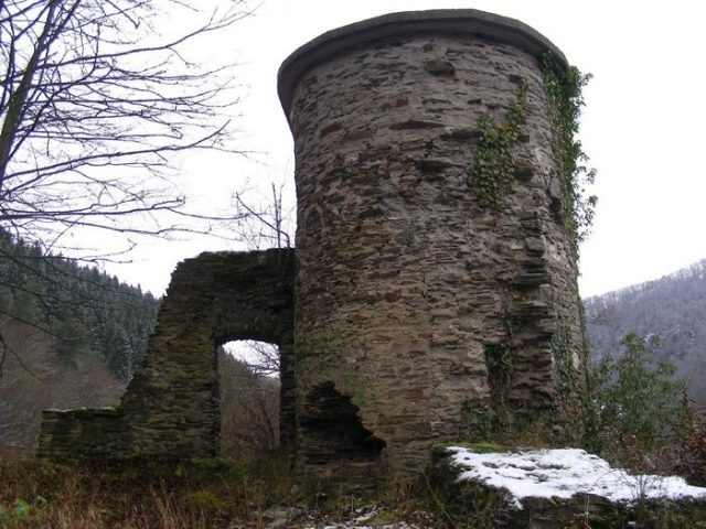
In 1551, a branch of the family still lived in the ancestral castle; in 1569, with the extinction of the line, it reverted to Hesse as an escheated fief. Subsequently, the complex fell into disrepair and was already referred to as a ruin in 1585. Around 1840, the name Junkerburg is documented, also later, but much less frequently Schwarzenberg. In recent times, there have been confusions of the names of the two Geroldstein castles, so that until recently, some maps also show the name Haneck Castle for the older castle, actually called Geroldstein. Of the former castle complex, only a round tower, remains of a gate system, and some wall remnants are preserved.

Take Mobile History with you

You are reading this text for free. Premium adds what matters on the road: descriptions read aloud, sites found through your camera, whole regions taken offline.

  • Every description, including the ~17,700 Premium sites
  • Audio guide: have descriptions read to you on location
  • AR finder: see sites through your camera, with distance and bearing
  • Unlimited saved sites

14 days free, then from €2.99 a month. Cancel anytime.

Source: Wikipedia · Licence: CC BY-SA 4.0

This description draws on the facts documented in the linked Wikipedia article; Wikipedia content is licensed under CC BY-SA 4.0. Wording and editing: Mobile History.

Location: 50.1065, 7.9410