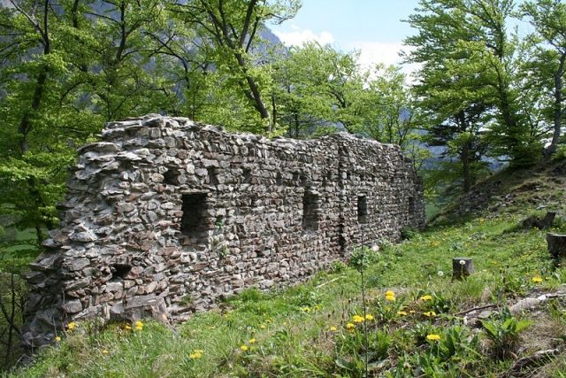
The remains of the Castle can be visited
Grafenberg Castle (Ruin) (Maienfeld)

The ruins of the former Grafenberg Castle, popularly known as Mörderburg (Murder Castle), are located west above the road from Maienfeld to Balzers in the Swiss canton of Graubünden.
Location+
The ruins are situated on an elongated rocky outcrop not far from the national border with the Principality of Liechtenstein. They belong to the municipality of Fläsch, but the castle hill itself belongs to the Liechtenstein municipality of Balzers. The site is easily accessible from the road via a forest path (no vehicles allowed) in about a quarter of an hour.
Name+
Among chroniclers, Ulrich Campell mentions the name as Grafenberg around 1579, Fortunat Sprecher as Castrum Graffenberg in 1617, and Nicolin Sererhard as Schloß Grafenberg in 1742. The castle is not mentioned in contemporary documents and cannot have been the seat of a comital family.
An explanation for the name can perhaps be found in a derivation from Grawinberg; Middle High German grâ, grâwes for grey. The name could refer to the rocky surroundings or the castle itself. Thus, Grawinberg became Grafenberg, as for the locals, the connection of the castle with a count seemed more plausible than with the color grey.
The name Mordtburg, documented as early as 1498, is to be seen in connection with a legend according to which the robber knights residing in the castle were said to have thrown the robbed merchants down the cliffs. In reality, however, the name Mörderburg could express the hostile relationship of the residents to the castle lords.
Structure+
The castle hill is separated from the mountain slope by a presumably artificially created neck ditch. Of the complex, a 25-meter-long and 6.5-meter-high wall of at least a two-story palas has been preserved on the northeastern slope. In addition to beam holes, four embrasure windows are visible, which open inwards into window niches.
Further wall remains along the southeastern and southwestern plateau edge suggest that the building had a floor area of approx. 41 x 11 m and thus covered the entire summit of the hill.
From the foot of the castle hill to the opposite Guschnerberg, a Letzi (defensive wall) extended, of which some remains are still preserved in the forest strip in the valley floor. It was stormed by imperial troops on January 5, 1499, during the Swabian War, and after a few days of occupation, it was recaptured by the Bündner.
Written records about the origin and history of the castle are missing. In a border description between Fläsch and Balzers, the Mordtburg appears in 1498. Masonry in opus spicatum as well as fragments of cup-shaped stove tiles indicate an origin in the 13th century. Burned debris inside the building suggests a fire.
Take Mobile History with you
You are reading this text for free. Premium adds what matters on the road: descriptions read aloud, sites found through your camera, whole regions taken offline.
- Every description, including the ~17,700 Premium sites
- Audio guide: have descriptions read to you on location
- AR finder: see sites through your camera, with distance and bearing
- Unlimited saved sites
14 days free, then from €2.99 a month. Cancel anytime.
Source: Wikipedia · Licence: CC BY-SA 4.0
This description draws on the facts documented in the linked Wikipedia article; Wikipedia content is licensed under CC BY-SA 4.0. Wording and editing: Mobile History.
Location: 47.0461, 9.5130