RuinWaldstetten

Granegg Castel (Ruin)

Granegg Castel (Ruin)

The remains of the Castle can be visited

Granegg Castle was a hilltop castle in the Wißgoldingen district of the municipality of Waldstetten in the Ostalbkreis. The castle site is located on the 200 m long, west-facing mountain spur of the Kalten Feld, known as Graneggle, at an altitude of [missing altitude in original]. South of the castle ruins runs the border between the Göppingen district and the Ostalbkreis.

Due to its location, the castle dominated the pass height of the Christental, barely 100 m away, near today's Reiterleskapelle.

Based on the bossed ashlar masonry, the construction period of the castle is placed in the 13th century; precise construction dates are unknown. The builders and owners of the castle are also unknown. Due to documentary mentions, the Lords of Stoffeln from the nearby Weilerstoffel, as well as the Lords of Holtz, are occasionally named as possible lords of Granegg. The von Holtz were ministeriales of the Rechberg family and owned estates in Tannweiler, Wißgoldingen, Winzingen, and in the Christental. However, their existence as lords is unproven for both families.

Whether the castle was destroyed or abandoned is unknown due to a lack of documents. It is generally assumed that Granegg did not exist for very long and was abandoned by the 14th century at the latest. It is no longer recorded on the hunting map drawn by Balthasar Riecker in 1572. The ruins were first mentioned in 1674 by the chronicler Friedrich Vogt from Schwäbisch Gmünd.

Description+

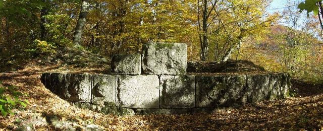
Contemporary views of Granegg Castle are not known. The 60 x 22 m castle complex was separated from the Kalten Feld by a 4 m deep neck ditch; an outer bailey is not detectable. Individual wall remnants are still located on the now forested area. Particularly visible are the foundation remnants of the round keep with an outer diameter of 8.62 m and an inner diameter of 3.62 m, with a wall thickness of 2.50 m. The White Jura stones of the keep are said to have served as building material in neighboring villages in the past.

Around 1885, remnants of a cellar vault with a cellar staircase were reportedly still visible.

Take Mobile History with you

You are reading this text for free. Premium adds what matters on the road: descriptions read aloud, sites found through your camera, whole regions taken offline.

  • Every description, including the ~17,700 Premium sites
  • Audio guide: have descriptions read to you on location
  • AR finder: see sites through your camera, with distance and bearing
  • Unlimited saved sites

14 days free, then from €2.99 a month. Cancel anytime.

Source: Wikipedia · Licence: CC BY-SA 4.0

This description draws on the facts documented in the linked Wikipedia article; Wikipedia content is licensed under CC BY-SA 4.0. Wording and editing: Mobile History.

Location: 48.7299, 9.8406