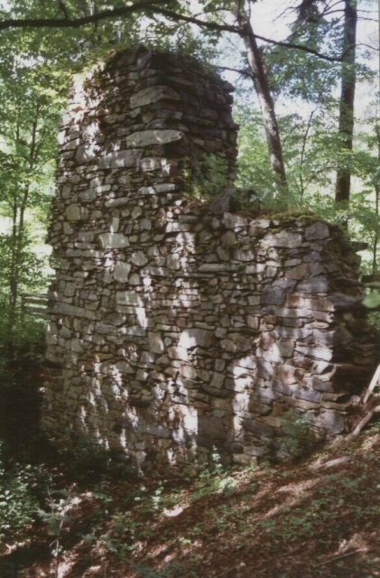
The remains of the Castle can be visited
Grünstein Castle (Ruin)
Grünstein is a castle ruin in the Grünstein district of Gefrees in the Bayreuth district of Upper Franconia. Similar to the neighboring Stein Castle, Grünstein Castle presumably dates back to the Walpoten. In the Henneberg enfeoffment register, it is listed as Butzengerute in 1332. The vanished village of Putzenreuth was in the immediate vicinity, and Putzenberg and Putzenbach also derive from it. The castle was mentioned on May 11, 1361, when the Nuremberg Burgrave Friedrich V allowed the brothers Hans and Arnold von Hirschberg to build a castle and reserved rights of access. The castle was already referred to as a castle site at this time and was rebuilt afterwards.
In the Field of Tension Between the Bamberg Bishops and the Nuremberg Burgraves
The reconstruction of Grünstein corresponded to the expansionist policy of the Burgraves in the region and formed a counterpoint to the efforts of the Bamberg bishops. The influence of the bishops and the burgraves in the region was long considered controversial and was only regulated in 1538 in the Treaty of Forchheim. Despite the right of access, the Bamberg bishops exerted influence over Grünstein during the 14th century. The former Henneberg fief passed to the bishops.
Enfeoffments to the Lords of Hirschberg by the Bamberg bishops are documented from 1447 to 1557. In 1447, there was talk of Hans von Hirschberg zu der Weißenstadt. In addition to the destruction before 1361, combat operations during the German Peasants' War are verifiable. In 1580, the property passed to the von Wallenrode family. The first owner was Hans Ernst von Wallenrode, bailiff of Streitberg. In the mid-17th century, the enfeoffments to the Wallenroder family ended, and the property reverted to the Bamberg bishops. The decay of the castle must also have begun during this period.
Appearance and Location+
The relatively small castle area rises on a hill in the form of a low mountain spur, which is flowed around in parallel by Kornbach and Mühlbach. On the access side, remains of trench systems can be found. In the time of Johann Christoph Stierlein, who carried out a first topographical survey in 1795 and illustrated it with a watercolor, a square two-story main building was preserved at the tip of the spur. A hill, "consisting entirely of rubble" to the right of the access, indicates another larger building or a tower. Traces of trenches and outer walls are also still visible. Maps from the original survey of 1852 document the further decay, especially of the main building, of which only two outer walls remained. Today, only a wall remnant and an adjacent cellar are present.
Take Mobile History with you
You are reading this text for free. Premium adds what matters on the road: descriptions read aloud, sites found through your camera, whole regions taken offline.
- Every description, including the ~17,700 Premium sites
- Audio guide: have descriptions read to you on location
- AR finder: see sites through your camera, with distance and bearing
- Unlimited saved sites
14 days free, then from €2.99 a month. Cancel anytime.
Source: Wikipedia · Licence: CC BY-SA 4.0
This description draws on the facts documented in the linked Wikipedia article; Wikipedia content is licensed under CC BY-SA 4.0. Wording and editing: Mobile History.
Location: 50.0889, 11.7268