RuinLaufenburg-Hauenstein

Hauenstein Castle (Ruin)
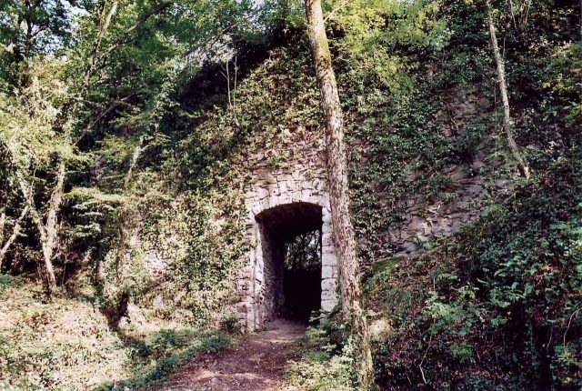
Hauenstein Castle (Ruin)

The remains of the Castle can be visited

Hauenstein Castle is a ruined castle in Hauenstein, a district of the municipality of Laufenburg am Hochrhein, in the Waldshut district of Baden-Württemberg.

Hauenstein Castle is located on a rocky ridge of very hard porphyry, rising from the Rhine, steeply above the small town of Hauenstein. The castle complex runs diagonally from north-east to south-west. The elevated position and a bend in the Rhine allow for a wide view up and down the river. An important trade route followed the Rhine bank as early as Roman times. Together with the surrounding river valleys of the Alb, Schlucht, and Wehra, it forms an enclosure. Thus, even with natural means, it was possible to control both land and river traffic on the Rhine. It should be noted that the current road (towards Hochsal) was only broken through the rock massif much later.

Purpose of the Complex+

The complex was probably built to secure the Säckingen Monastery. In various old documents, Hauenstein is also associated with the snowmelt border of the Black Forest, which thus also represented a natural border. There were certainly enough reasons to secure this strategically important border point at precisely this location to justify the construction of a castle as early as the Early Middle Ages, if not even at the end of antiquity.

Due to the natural narrowing of the trade route running below the castle, the connecting road in east-west direction, and shipping on the Rhine, the routes could be excellently monitored from this point, and tolls could be collected without major difficulties, as bypassing it on the right bank of the Rhine by land was only possible with considerable effort at that time due to another natural barrier, the Alb gorge, especially since the only river crossing there was additionally blocked by Tiefenstein Castle.

Hauenstein Castle, an imperial fief, was the seat of the Waldvogtei (forest bailiwick) of the County of Hauenstein until 1500 and served as a customs building and regional administration.

Overall Complex+

Outlying Defensive Work

Access to the castle grounds was from the southwest. To the left of the access path ran a deep pointed ditch. In front of the castle were two more ditches, partly bordered by a rampart. The complex itself was protected from the southwest by a ditch and a rampart. Another ditch ran in front of the northeast wall. From the northwest, the castle was provided with an artificially created pond, which was fed by an artificially created weir, hidden with wood and earth. The water for this came from Hochsal, about two kilometers away. Remains of this weir are still present today. The excess water flowed through a specially constructed ditch that ran along the southwestern part, below the castle, and from there along the southwestern city walls of the outer bailey, towards the Rhine.

The Castle Complex

The complex was altered and extended several times. Some extensions can still be clearly recognized, even from the largely dilapidated state of the building today. The oldest part of the castle is probably the southwest part. There, a building adjoins the complex, which, due to its octagonal ground plan, still partially recognizable today, suggests a medieval construction probably in the 10th or 11th century. It is possible that this part was already fortified during the Carolingian period and thus was already the seat of the Gau counts of the Albgau in the early phase. Further investigations are necessary for an exact dating of the complex.

The approximately 3-meter-thick shield or curtain wall, facing northwest, with a wooden battlement running above it, was added in a later construction phase to the diagonally running masonry of the old palas, which may originally have been merely a fortified house. This addition can still be clearly seen today (see image of wall junction), because the added shield wall is narrower than the leg length of the octagonal palas, creating a niche on the inside of the shield wall. The later addition of the shield wall to the old palas thus preserved, in a way, the octagonal ground plan of the palas in the northwest, which is important for dating. This is all the more important as the opposite palas walls in the southwest are heavily damaged or no longer exist. The course of the wall inside the castle has been greatly altered or disfigured. The seemingly continuous wall section that presents itself to the visitor today behind the visitor information board probably only partially belongs to the castle complex and was largely erected in a much later construction phase (presumably late 19th century). Only the left (southwestern) part of this wall, which impresses today with its large and heavy ashlar stones, is likely to be part of the old complex. This wall section is, in all appearances, the inside of the old keep and not the outside of another building (tower), as the accumulated rubble behind it suggests today. The right part of this wall, often referred to as the southeast wall of a residential building (palas), probably does not belong to the original construction. The course of the old palas wall in the southeast is much more likely to be a rather inconspicuous, diagonally running wall section today, which, from today's perspective, appears illogical and meaningless in its detached position from the palas. However, with regard to an octagonal palas, this wall makes perfect sense again. It is now highly probable that the southeast wall of the palas (possibly during the fire in 1503 or already during the earthquake in 1356) collapsed and that during the partial reconstruction (probably 1644 or 1892, possibly also 1370), the south wall was set back by about three meters, added to the inner, diagonal end of the octagon, and thus the palas was significantly reduced in size. Measurements of the leg lengths and angles of the respective walls could provide information on this. The old main castle probably consisted of a residential tower (donjon), an octagonal palas, and a smaller utility building or stable. Whether a residential tower first and then the octagonal palas, or vice versa, or possibly even both buildings stood side by side at the same time, cannot be definitively stated.

Dimensions and Condition of the Castle Complex

Arthur Hauptmann states the length of the shield wall as around 70 meters. This does not seem to take into account the north wall of the palas. The total length of the wall of the old palas running in a northwesterly direction, together with the later added fortress wall, should be about 95 meters. Latest findings suggest that the complex originally even extended over the plateau at the northern end. This would have made the entire complex about 140 meters long, making it one of the largest castle complexes on the Upper Rhine. The length of the diagonally running southwest wall, adapted to the terrain, is about 17 meters; the southeast wall of the main castle up to the former gate of the main castle measures about 35 meters. After that, the wall runs at an angle of about 90° outwards to the rock edge. A horseshoe-shaped round tower adjoins this approximately 10-meter-long wall, turning into the inner courtyard of the castle and having a diameter of about 10 to 15 meters. Following the rock edge in a northeasterly direction ran the largely collapsed southeast wall today, which is attached to the upper third of the round tower and was about 50 meters long. In a rounded edge, it merges into the northeast wall, which measures about 30 meters at the outer end of the two rounded wall ends. The northwest and northeast walls are, thanks to renovation work around 1892, still relatively well preserved, with the exception of the palas north wall, and impress with their thickness of more than three and a height of up to about seven meters in places. The eastern part of the southeast wall has largely collapsed or was used as a quarry in the 18th century and removed in the 19th century due to the risk of rockfall. Stones from the castle ruins were probably also used for the construction of the nearby railway viaduct. In the southern part of the southeast wall, in the area of the main castle, the remains of a round tower and wall fragments are preserved. This round tower, if at all, probably only protruded slightly above the upper ground level.

Large parts of the complex are overgrown with plants today. Inside the complex, there are also numerous shrubs and bushes, which make proper access and a clear view of the complex very difficult. The masonry of the palas urgently needs renovation work, as the mortar is brittle in many places and thus the masonry loses its hold.

Characteristics

The current access to the castle is in the northwest wall and leads through a 3.6-meter-high and 2.1-meter-wide, arched gate into the interior of the castle. Whether this is the historical access is doubted in various circles. A possible access from the northeast is also discussed. Possibly, a gate led through a tower that may have stood there, which could span the ditch there with the help of a drawbridge. A 19th-century sketch shows accesses at both locations. The castle path in the northwest wall, which leads through the diagonally arranged gate in the north wall, ascends in a slight right curve to the old palas or the core or main castle, which was secured with another gate. Deeply embedded in a hollow lane, the access was well defensible. Old descriptions indicate that the palas stood here in the west on the outermost rock tip. From Luttingen, a suburb of Hauenstein, the palas resembled a keep, which, according to Metz, probably did not exist in this form at this location. Old reports speak of two castles, each located on a rock "a stone's throw" from each other. This probably referred to the old palas building in the south and another castle in the north of the complex.

The Old Main Castle

The terrain of the old main castle runs slightly V-shaped and has a length of about thirty-five meters from the northeast to the southwest wall. At the south end, it measures a width of about sixteen meters, and at the north end, about twenty meters. The current access and the round tower are not taken into account, as these were probably built later. The appearance of the old castle's buildings is unclear. Some experts assume a residential tower at the outermost southern tip. However, it is also possible that the still existing north wall was part of a palas. Assuming this, it would have had a width of about ten meters and a length of about thirty meters, provided it actually reached the outermost end of the rock edge, as is handed down in old descriptions. However, it is more likely that the palas was only about twenty meters long and reached up to a projecting wall remnant that still exists today. This possibility would allow for the construction of other necessary utility buildings that would otherwise not have had space in the remaining palas forecourt (see model). This small forecourt was sealed off from the rest of the complex by another gate. In a further expansion phase, a round tower was added to the old main castle in the northeast, which probably formed a self-contained unit with another ring wall leading to the current castle access. A large keep at this point of the complex can probably be ruled out due to the relatively small wall thickness of about 1.8 meters.

The New Castle

Later, the northwest wall was significantly extended, so that it was now ninety-five to one hundred meters long. In the northeastern part of the complex, there was probably a tower about thirteen by ten meters in size, to which a solidly built "knight's house" about sixteen by ten meters long was attached. It is likely that only the rear (fortress) wall and side walls (fortress wall and tower) of this house, as well as the first floor of the front, were solidly built. The second and possibly third floors, however, were probably added in timber construction.

The Castle Courtyard

Between the two "castles" was an inner courtyard about forty-five meters long and about twenty-nine meters wide, in which, judging by the existing rubble heaps, there were other buildings. Numerous rafter holes on the northwest wall, presumably equipped with a wooden battlement, can still be seen today. These were probably predominantly wooden houses. The "knight's house" and the tower in the northeast of the complex are most likely to fall into the same construction phase as the attached northeast wall. Here, in contrast to the southwestern residential tower, no wall junction can be seen. The wall thickness here is also consistent with the fortress wall. The walls in the southwestern, old palas, however, are significantly thinner.

Historical Descriptions of the Castle+

Year 1471

Wernet describes the castle complex in his book "Der Hauensteiner Landfahnen" as follows: "We owe the most detailed description of the condition of Hauenstein Castle to a report by two commissioners of Charles the Bold, Duke of Burgundy, from the year 1471. They describe the place Hauenstein as a market town with a few houses, fortified with a miserable wall, through which an upper and a lower gate led. Two castles, each on a rock above the Rhine, completed the defense. Wilhelm von Griessen held one as a fief from the Duke of Burgundy. The other the Duke had reserved for himself. It consisted of a large, but very dilapidated tower, with a small wooden dwelling enclosing an oven, a room, and a stable for two to three horses. Above the house were a barn, a garden, and a meadow."

Year 1580

In 1580, Christian Wurstisen describes Hauenstein as follows: "Not far from Waldshut, on the Rhine, lies the walled town of Hauenstein, with an old castle, which once had its own lordship. In the year 1108, Hauenstein was bought and exchanged for St. Blasien, as a register there indicates, but with whom this exchange took place is not mentioned. It remained with the monastery until the last Duke of Zähringen, after whom it came to the Counts of Freyburg, and finally to the House of Austria. Martin Freyherr von Stauffen wrote himself as the Vogt (bailiff) of the Lordship of Austria in Lauffenberg, Waldshut, and Seckingen, Vogt of Hauenstein Castle, and the four places of the Black Forest, belonging to the County of Hauenstein, in the year 1476. The castle was burned down seventy years ago by a fire that started in hemp that the women had there, so that only a poor house and tower remained for the forest bailiff as a prison. The Alb flows from the Black Forest closest to it into the Rhine." Wurstisen thus confirms the purchase by St. Blasien in 1108, but unfortunately does not provide a source for it.

Year 1663

In 1663, Matthäus Merian wrote about Hauenstein: "Below Waldshut / and about an hour's walk above Lauffenberg / lies the small town of Hauenstein / or Howenstein / on the Rhine / which is only / like a poor little place: also Austrian. In former times there stood an old elegant castle on the rock there / of which a tower still remains / in which the forest bailiff has his prison."

Year 1833

Karl Heinrich Ludwig Pölitz writes in "Jahrbücher der Geschichte und Staatskunst" (Yearbooks of History and Political Science) 1833: "...such remained a considerable castle, until it too, in the Peasants' War, shared the fate of destruction with so many other castles, after having already suffered much from fire earlier."

Castle Chapel+

The chapel belonging to the castle, dedicated to Saint Joseph, is located below the rock edge between the main castle and the outer bailey (the small town of Hauenstein). The construction of the chapel is said to date back to 1215. In 1503, the chapel burned down along with the castle. In 1641, it was decided to rebuild the chapel. A sandstone above the entrance bears the year 1685. In 1797, the chapel was plundered by the French. The citizens were able to prevent a demolition in 1826. In 1949, the chapel was fundamentally renovated. It is the only completely preserved building belonging to the castle.

The Outer Bailey+

The outer bailey mentioned in some reports refers to the small town of Hauenstein, located below the castle, facing the Rhine bank. Joseph Merk of Freiburg also recognizes this in his description "Geschichte des Ursprunges, der Entwicklung und Einrichtung der hauensteinischen Einung im Mittelalter" (History of the Origin, Development, and Establishment of the Hauenstein Union in the Middle Ages). Whether there was access from the outer bailey, i.e., the town of Hauenstein, to the main castle steeply above it, is not known. Possibly there was a connecting passage in the round tower. For a long time, it was doubted whether the outer bailey, i.e., the town of Hauenstein, even had fortifications. It is certain that there was a city wall to the west. This still exists in large parts, but cannot be easily identified, as it has been converted into the gable wall of an attached house. The thickness of about one meter reveals that these are remnants of the city wall and not a house wall. The course with overlying wall remnants, which could probably never have belonged to a house, further confirms the existence of a city wall in the west. If, consequently, a west wall was present, the outer bailey was protected to the north by the main castle and from the south by the natural barrier of the Rhine, why then should the only remaining access from the east not have been fortified, especially since it is only about 20 meters wide? This is rather unlikely, so it can be assumed that the small town of Hauenstein was also fortified all around. A report on the town of Hauenstein from the end of the 18th century confirms this assumption. It states: "This town consists of 18 houses, which are very small and poorly built, and can be closed with two gates..."

Take Mobile History with you

You are reading this text for free. Premium adds what matters on the road: descriptions read aloud, sites found through your camera, whole regions taken offline.

  • Every description, including the ~17,700 Premium sites
  • Audio guide: have descriptions read to you on location
  • AR finder: see sites through your camera, with distance and bearing
  • Unlimited saved sites

14 days free, then from €2.99 a month. Cancel anytime.

Source: Wikipedia · Licence: CC BY-SA 4.0

This description draws on the facts documented in the linked Wikipedia article; Wikipedia content is licensed under CC BY-SA 4.0. Wording and editing: Mobile History.

Location: 47.5820, 8.1065